

Short- and long-term hydrologic controls on smouldering fire in wetland soils
Morgan L. Schulte A , Daniel L. McLaughlin B H , Frederic C. Wurster C , J. Morgan Varner D , Ryan D. Stewart E , W. Mike Aust B , C. Nathan Jones F and Bridget Gile GA North Carolina State University, Department of Forestry and Environmental Resources, 2800 Faucette Driver, Raleigh, NC 27695, USA.
B Virginia Tech, Department of Forest Resources and Environmental Conservation, Cheatham Hall, Blacksburg, VA 24061, USA.
C Great Dismal Swamp National Wildlife Refuge, US Fish and Wildlife Service, 3100 Desert Road, Suffolk, VA 23434, USA.
D Pacific Wildland Fire Sciences Laboratory, US Forest Service Pacific Northwest Research Station, 400 N. 34th Street, Seattle, WA 98103, USA.
E Virginia Tech, Department of Crop and Soil Environmental Sciences, Smyth Hall, Blacksburg, VA 24061, USA.
F National Socio-Environmental Synthesis Center, 1 Park Place, Annapolis, MD 21401, USA.
G Villanova University, Department of Civil and Environmental Engineering, 800 E. Lancaster Avenue, Villanova, PA 19085, USA.
H Corresponding author. Email: mclaugd@vt.edu
International Journal of Wildland Fire 28(3) 177-186 https://doi.org/10.1071/WF18086
Submitted: 11 June 2018 Accepted: 17 December 2018 Published: 21 February 2019
Journal compilation © IAWF 2019 Open Access CC BY-NC-ND
Abstract
Smouldering fire vulnerability in organic-rich, wetland soils is regulated by hydrologic regimes over short (by antecedent wetness) and long (through influences on soil properties) timescales. An integrative understanding of these controls is needed to inform fire predictions and hydrologic management to reduce fire vulnerability. The Great Dismal Swamp, a drained peatland (Virginia and North Carolina, USA), recently experienced large wildfires, motivating hydrologic restoration efforts. To inform those efforts, we combined continuous water levels, soil properties, moisture holding capacity and smouldering probability at four sites along a hydrologic gradient. For each site, we estimated gravimetric soil moisture content associated with a 50% smouldering probability (soil moisture smoulder threshold) and the water tension required to create this moisture threshold (tension smoulder threshold). Soil properties influenced both thresholds. Soils with lower bulk density smouldered at higher moisture content but also had higher moisture holding capacity, indicating that higher tensions (e.g. deeper water tables) are required to reach smouldering thresholds. By combining thresholds with water level data, we assessed smouldering vulnerability over time, providing a framework to guide fire prediction and hydrologic restoration. This work is among the first to integrate soil moisture thresholds, moisture holding capacities and water level dynamics to explore spatiotemporal variation in smouldering fire vulnerability.
Additional keywords: Great Dismal Swamp, ignition thresholds, moisture holding capacity, organic soil, soil properties.
Introduction
Globally, hydrologically altered peatlands have been severely affected by smouldering fires, resulting in large carbon emissions (Page et al. 2002; Turetsky et al. 2015). Peatlands cover only ~3% of the Earth’s land surface, but store almost one-third of the Earth’s terrestrial carbon (Turetsky et al. 2015). Pervasive wetland drainage and hydrologic alteration threaten these carbon stores by lowering water tables and increasing the severity and frequency of smouldering fires (Page et al. 2002; Atkinson et al. 2003). In contrast to flaming fires that primarily burn aboveground fuels, smouldering fires start on the surface, then spread vertically and laterally consuming organic-rich soils (Huang and Rein 2018). Smouldering fires can last for days to months (Page et al. 2002), consume as much as 1–2 m of soil depth over extensive areas (Watts and Kobziar 2013; Reddy et al. 2015), and emit enormous amounts of carbon to the atmosphere (Usup et al. 2004). For example, smouldering fires in 1997 burned 0.73 Mha of forested peatland in Central Kalimantan, Indonesia, releasing an estimated 190–230 Tg of carbon (Page et al. 2002). The 2008 Evans Road Fire burned 16 800 ha at Pocosin Lakes National Wildlife Refuge in the southeastern USA and released an estimated 0.31 Tg C by belowground consumption alone (Mickler et al. 2017).
Smouldering ground fires can also have direct effects on ecosystems and human health. In some ecosystems, such as Taxodium spp. swamps, low to moderate severity fires can regulate species composition, leaving cypress trees alive while killing potential competitors (Watts and Kobziar 2013). Severe fires, however, can cause total tree mortality and induce dramatic species shifts from forested swamp to herbaceous marsh species (Casey and Ewel 2006). Moreover, smouldering fire fronts are difficult to locate and costly to extinguish (Rein 2016) and generate thick smoke that can cause local health problems and traffic hazards (Poulter et al. 2006; Rappold et al. 2011; Parthum et al. 2017).
Increasingly, land managers are working to mitigate and better predict smouldering fires in peatland ecosystems. One of the most common mitigation strategies is to block drainage ditches with earthen plugs or engineered structures to raise peatland water levels (Chimner et al. 2017). Numerous researchers have evaluated the success of such strategies in restoring historical peatland hydrology (see Chimner et al. 2017), but their success in reducing smouldering fire risk has not been investigated. Additionally, although strategies for predicting aboveground fire risk are common and have existed in the United States since 1916 (Andrews et al. 2007), there are comparatively few fire prediction strategies for smouldering ground fires (Reardon et al. 2007). Beginning in the late 1990s, fire management programs in peatlands have been working to develop fire prediction protocols largely using climate data to predict soil moisture regimes and associated fire risk (Lawson et al. 1997; de Groot et al. 2007; Fire Environment Working Group 2009). Our research proposes an integrative approach that links in situ hydrologic data, soil properties and resultant smouldering fire risk to further advance fire prediction strategies and assess water level management efforts. With this approach, we address the integrated influences of hydrologic regime that determine the vulnerability of a soil to ignition and subsequent and sustained smouldering.
Hydrologic controls on smouldering fire
Hydrologic controls on smouldering fire vulnerability are two-fold, occurring over both short (days) and long (~decades) timescales. First, soil moisture is the primary driver of organic soil smouldering (Frandsen 1997; Reardon et al. 2007; Rein et al. 2008). As such, short-term variation in soil moisture and thus in antecedent precipitation, evapotranspiration and water table levels largely control fire vulnerability over time in a given location. However, the soil moisture threshold below which smouldering is possible depends on soil properties, which can spatially vary and change as a function of long-term hydrologic regime. For instance, soils with increased long-term wetness typically have lower mineral content and bulk density due to higher organic matter accumulation (Verry et al. 2011). Such low mineral content and low bulk density soils have been correlated with higher soil moisture thresholds (i.e. they smoulder at higher soil moistures; Hartford 1993; Frandsen 1997; Reardon et al. 2007). However, moisture holding capacity – which represents the relationship between water tension (e.g. depth to water table) and resulting gravimetric soil moisture content (Verry et al. 2011) – is also typically higher in low mineral content, low bulk density soils (Boelter 1968; Verry et al. 2011). Greater water-holding capacity means that soils can maintain elevated soil moistures even at high water tensions (e.g. deeper water tables), possibly decreasing fire vulnerability. These two contrasting properties associated with low mineral content soils (i.e. they smoulder at high soil moistures but also have high water-holding capacities) highlight an additional, but largely understudied, long-term hydrologic influence on soil properties that in turn regulate fire vulnerability.
Fire history at the Great Dismal Swamp
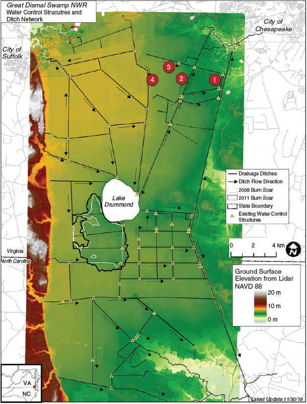
Understanding hydrologic controls on fire vulnerability is particularly important in hydrologically altered peatlands such as the Great Dismal Swamp (GDS; Fig. 1), where pervasive ditching and recent large-scale fires have occurred. GDS once extended across ~500000 ha with up to 5 m deep organic soils (Osborn 1919) but was extensively ditched and drained for timber harvesting (Levy 1991). This drainage resulted in lowered water levels, likely increasing both fire vulnerability and attendant soil carbon loss. Two notable and recent catastrophic smouldering fires have occurred at GDS. In June 2008, the South One Fire occurred when logging equipment caught fire and ignited timber slash and underlying organic soils, ultimately burning 1980 ha in over 4 months (white boundary in Fig. 1). The South One Fire resulted in average soil loss of 0.17 m and complete overstorey tree mortality (Hawbaker et al. 2016). Subsequently in August 2011, the Lateral West Fire was ignited by lightning and spread through the previous 2008 fire scar. After 4 months, the Lateral West Fire burned 2500 ha, released 1.10 Tg C and consumed an average of 0.5 m of soil with localised consumption up to 1 m deep (Reddy et al. 2015; black boundary in Fig. 1). Combined fire-suppression costs for these two fires approached US$25 million. Parthum et al. (2017) estimated that avoiding the 2008 fire alone would have saved ~US$3.69 million in regional cost of illness from smoke exposure. Such costs and consequences have motivated the GDS National Wildlife Refuge to reduce the risk of severe smouldering fires by re-establishing historical hydrology. To do so, engineered water-control structures have been installed in ditches to manage water levels and slow drainage (Wurster et al. 2016). This study seeks to inform water level management at GDS by linking hydrologic regime and fire risk, thereby improving current fire prediction protocols. More broadly, our research develops an approach for guiding fire prediction and hydrologic restoration across peatlands affected by drainage and susceptible to smouldering ground fires.
|
To address both short- and long-term hydrologic controls on fire vulnerability, we integrated continuous water level data, soil property characterisation and laboratory smouldering tests using sites spanning a hydrologic gradient. We expected that soils with higher long-term water levels would have lower bulk density and mineral content and thus higher soil moisture smoulder thresholds (i.e. smoulder at higher gravimetric soil moistures; H1). However, we also expected that moisture holding capacities would be higher in low bulk density soils (and thus with increased long-term wetness), thereby potentially reducing the frequency at which smoulder thresholds will be reached (H2). Lastly, we predicted that wetter sites would have lower fire vulnerabilities through the integrated effects of site-specific soil moisture thresholds, moisture holding capacities and short-term water level dynamics (H3). To test these hypotheses, we determined site-specific gravimetric soil moisture thresholds for smouldering and the required water tension threshold to reach these soil moisture thresholds (by moisture holding capacities). We then combined identified thresholds with continuous water level data to explore temporal trends in burn probabilities across our sampled sites.
Materials and methods
Site description, data collection and soil sampling
We monitored water level dynamics and sampled soils at four sites in the north-eastern corner of the GDS National Wildlife Refuge (Fig. 1). GDS is a freshwater, forested peatland covering 45 000 ha in the coastal plain of south-eastern Virginia and north-eastern North Carolina, USA (36°42′28″N, 76°23′46″W). The climate is temperate with long humid summers and mild winters, and mean annual precipitation of 1180 mm (1981–2010; National Oceanic and Atmospheric Administration, https://www.ncdc.noaa.gov/cdo-web/datasets, accessed 29 January 2019). Maple (Acer spp.)–gum (Nyssa spp.) is the dominant forest cover type (Levy 1991). Soils on the refuge are predominantly hydric and organic rich, but can range from sandy loam to fibric peat (Natural Resources Conservation Service 2017).
We selected our four sites to capture variation in water level regimes largely driven by ditch drainage and road impoundments, with sites numbered from 1 to 4 by increasing wetness (Fig. 1). Monitoring wells were previously installed at each site by GDS and US Geological Survey staff. Vented submersible pressure transducers (Campbell Scientific CS 450, Campbell Scientific, Logan, UT, USA; In-Situ Level Troll 500, In-Situ Inc., Fort Collins, CO, USA; and KPSI 500; Pressure Systems Inc., Newport News, VA, USA) in each well provided continuous 15-min water level data for 16 months (April 2015–July 2016).
In summer 2016, we collected soil samples near each site’s monitoring well (25 total samples per site). Samples were used to characterise each site’s soil properties (3 samples per site), to conduct smouldering testing (18 samples per site) and to construct moisture release curves (4 samples per site). To characterise surface soils at each site, we collected surface samples (i.e. excluding overlying root mass) within a 3 × 3-m area surrounding each well. Here, we focussed on surface soils because they are the likely source of ignition and initiation of a smouldering front (Benscoter et al. 2011), and we removed overlying root mat to limit variation from overlying vegetation cover. To maintain field bulk density, we first cut the root mat (varied in depth from ~5 to 10 cm) with hand tools and removed it to expose underlying soil. A flat edge, large diameter corer (diameter = 15.4 cm) was used to cut a 5 cm deep circle vertically down into the soil, yielding a sample volume of 930 cm3. A PVC pipe with identical dimensions as the corer was fit into the vertical cut to house the sample and protect the soil structure. A hand tool was used to cut the bottom of the sample horizontally and free it from underlying soil. Samples were carefully removed, reinforced with cardboard and sealed in plastic bags. All samples were stored at 4°C until analysis to minimise decomposition. We analysed three of the soil samples for bulk density (oven-dried at 105°C) and organic matter content (loss on ignition at 500°C for 24 h).
Smouldering probabilities
To identify site-specific gravimetric soil moisture values for smoulder thresholds, we conducted laboratory smouldering experiments using 18 samples per site. Samples were initially saturated, and then moisture content was manipulated by air-drying samples on an open rack for different durations. Smouldering testing, following methods reported by Frandsen (1997), took place in 10 × 10 × 10 cm (inner dimensions) open-topped combustion frames lined with cement board. The circular soil sample was cut into a 10 × 10 × 5-cm block and placed in the combustion frame. The remaining sample was weighed, oven-dried at 65°C for 48 h, and weighed again to determine gravimetric moisture content (GMC, calculated as grams of H2O per 100 grams of dry soil and reported as a percentage). Similar to previous studies (e.g. Hartford 1993; Frandsen 1997; Reardon et al. 2007), we held a 500-W (compared with 100 W in Huang and Rein 2018) electrically powered hot coil to the sample in the combustion frame. After 5 min, the coil was removed. After an additional 5 min, if any portion of the sample was still independently smouldering, the sample was considered dry enough to maintain smouldering with sufficient heat to both remove moisture and induce ignition temperatures in adjacent, unburned soils. This approach was intended to represent field conditions where a temporary ignition source (e.g. lightning) may or may not result in a maintained and spreading smouldering front (see Frandsen 1997). For each sample, a binary response was recorded: smoulder (1), where smouldering was observed after 5 min, or no smoulder (0).
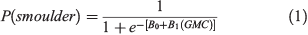
For each site, data for smouldering response and GMC were fit with a logistic regression (R Core Team 2016) to quantify smouldering probability P(smoulder) as a function of GMC:
where B0 and B1 are unitless fitted parameters. Following Frandsen (1997) and Reardon et al. (2007), we solved for gravimetric moisture content at 50% smouldering probability to indicate a smoulder soilmoisture threshold (hereafter GMCsmoulder) for each site by rearranging Eqn 1 as:

Soil moisture holding capacity
To quantify moisture holding capacity across sites, we developed moisture release curves for each sampling location using four subsamples (by soil rings with diameter = 5 cm and height = 5 cm), following the pressure-plate extraction method (Dane and Hopmans 2002). Saturated samples were weighed and placed on a porous, ceramic plate within a pressure chamber, where positive pressure was added in three steps (33, 100 and 300 kPa). At each pressure step, the samples were weighed after equilibrating. After the last pressure step, samples were oven-dried and weighed to determine dry soil mass, which was then used to calculate GMC at each pressure step. The points were fit with the Brooks and Corey (1964) model to calculate moisture release curves for GMC as a function of water tension (h; negative pressure as m H2O):
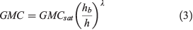
where GMCsat is defined as gravimetric moisture content at saturation, λ is a unitless variable related to pore size distribution, and hb is the air entry matric head (m H2O).
We then solved for site-specific water tension smoulder thresholds (hsmoulder) using the 50% smoulder probability (GMCsmoulder; Eqn 2):

Site comparisons of smouldering vulnerability
We compared smoulder thresholds for both soil moisture contents (GMCsmoulder) and water tensions (hsmoulder) across sites to evaluate effects of soil properties on smouldering probability. As part of this comparison, we used a Monte Carlo resampling approach to estimate the distribution of potential GMCsmoulder and hsmoulder values for each site. This entailed assuming a normal distribution of error around each model parameter in Eqn 2 and 4 (i.e. B0, B1, λ, hb), using parameter estimates and associated 90% confidence intervals (CI) to parameterise normal distributions, and then resampling each parameters distribution 1000 times to create 1000 separate models. We then solved for GMCsmoulder and hsmoulder for each of the 1000 individual models, and present means and standard deviations of the resulting distributions.
Lastly, we integrated site-specific smouldering thresholds and water level data at each sampling site to assess smouldering probabilities over the hydrologic monitoring period. Assuming hydrostatic equilibrium, hsmoulder represents the water table depth at which the soil surface reaches GMCsmoulder. As such, we used continuous water level data to calculate the proportion of time over the 16-month monitoring period that the distance from water table to ground surface exceeded hsmoulder. We used the R scripting language to conduct all analyses (R Core Team 2016).
Results
Soil properties
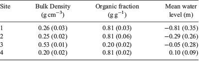
Our four sites provided a gradient of water level conditions and thus insights regarding hydrologic controls on soil properties (bulk density and organic content) that influence smouldering fire vulnerability. Over the 16-month monitoring period, mean water levels ranged from −0.81 m (i.e. 0.81 m below ground surface) at Site 1 (the driest site) to 0.10 m above ground surface at Site 4 (the wettest site; Table 1). Despite Site 3 having similar mean water level conditions (but with more temporal variation) as Site 4, it had the highest bulk density (0.53 g cm−3) and the lowest organic matter (20%), highlighting clear soil differences at Site 3. Indeed, this site is classified as an Ultisol, whereas as the other three sites are Histosols (Natural Resources Conservation Service 2017), and is located off of historical GDS peat deposits. Excluding Site 3, site mean bulk densities monotonically decreased with increasing wetness, ranging from 0.26 (at site 1) to 0.20 g cm−3 (at Site 4), but with equivalent mean organic matter content (0.81 g g−1; Table 1).
|
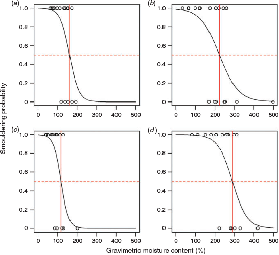
Soil moisture smoulder thresholds
We developed site-specific logistic relationships to predict smouldering probability (%) at a given GMC (Fig. 2; Table 2). A smoulder threshold was defined for each site as the estimated GMC at 50% smouldering probability (GMCsmoulder). We found increasing GMCsmoulder (Table 2) with increased mean water level and decreased bulk density at Sites 1, 2 and 4 (Table 1). Site 3 had the lowest GMCsmoulder (i.e. lowest soil moistures required for smouldering), consistent with this site’s high soil bulk density and low organic matter content compared with the other sites.
|

|
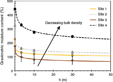
Moisture holding capacities
To explore differences in moisture holding capacities across sites and to link soil moisture smoulder thresholds with their associated water tensions (hsmoulder), we developed site-specific moisture release curves (Fig. 3; Table 3). At Sites 1, 2 and 4, we found an increase in moisture-holding capacity (i.e. higher GMC at specific tensions) with increasing mean water level and decreasing bulk density. Site 3 had the lowest moisture holding capacity and the highest bulk density. Using these curves, we calculated site-specific smoulder tensions (hsmoulder; Table 3) required to yield site-specific values of GMCsmoulder.
|

|
Site comparisons of smouldering fire vulnerability
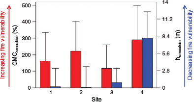
Using our developed models for smouldering probability and moisture release curves, we utilised a Monte Carlo resampling approach to estimate uncertainty around GMCsmoulder values (Table 2) and hsmoulder values (Table 3), the latter including uncertainty from both GMCsmoulder and moisture release curves. We note that this analysis assessed propagated uncertainty, but does not support statistical comparison across sites because simulation results are not true sample populations. Given these uncertainties, however, Site 4 had the highest GMCsmoulder value, suggesting that it had the highest vulnerability to smouldering based on soil moisture alone (left bars, Fig. 4). However, when also considering moisture-holding capacity, Site 4 had the highest hsmoulder value, indicating that it had higher required tension for smouldering vulnerability (right bars, Fig. 4).
|
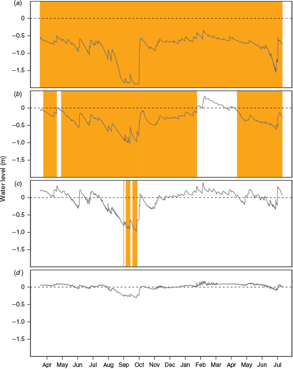
Assuming hydrostatic equilibrium, the hsmoulder threshold describes the required water table depth to reach GMCsmoulder at the soil surface. With this assumption, comparing hsmoulder values with water level data over the 16-month observation identifies periods when each site’s water levels reached site-specific smoulder-tension thresholds (Fig. 5). Water levels at Site 1 were always lower than the smoulder threshold, suggesting the site was always at risk to smoulder over the 16-month period. By contrast, Site 4 water levels were always higher than its threshold. Site 2 had extended periods reaching its smoulder threshold (79% of the 16-month monitoring period), whereas Site 3 infrequently reached thresholds (4% of the monitoring period) and only during the driest conditions. Although this analysis used mean hsmoulder values, we note that the estimated uncertainty around those values (Table 3) could be used to assess the resulting uncertainty in imputed timing of fire vulnerability.
|
Discussion
Our work addressed hydrologic controls on smouldering fire vulnerability in two key ways. First, we explored the effects of hydrologically driven soil properties on fire vulnerability (by both gravimetric soil moisture and required water tension thresholds). With these soil dependent threshold values, we then integrated both long- and short-term hydrologic controls by quantifying temporal trends of fire vulnerability using sub-daily water level time series. Our findings highlight important, in some cases opposing – and often understudied – influences of hydrologic regime on fire vulnerability. In doing so, our study presents a new approach that couples soil analyses and hydrologic monitoring to improve smouldering fire predictions and guide hydrologic restoration efforts aimed at reducing fire risk. However, our sampling sites, and thus the number of soils analysed, were limited to four, constraining our ability to statistically relate soil properties to soil moisture and tension threshold values. Further, assessed uncertainty in these thresholds for each site highlights the need for more site-level sampling. Consequently, we emphasise the importance of future sampling in GDS and elsewhere to build models that predict fire vulnerability using easily measured soil properties and water table regimes.
We predicted (H1) that wetter conditions decrease both soil bulk density and mineral content (i.e. higher organic content), which in turn affect fire vulnerability. With the exception of Site 3, sites had similar and high organic matter content (all with mean of 81%), inconsistent with our prediction of increased organic matter with wetness and suggestive of other possible influences, such as greater quantity or lability of vegetative inputs (Chambers et al. 2011). However, bulk density did decrease with wetness at Sites 1, 2 and 4 (Table 1), concordant with other studies in organic-rich soils (Chambers et al. 2011). Although our sample size limited statistical evaluation, a complimentary study at GDS from 20 locations also found significant negative associations between bulk density and mean water level and no observed trend in organic matter content (Schulte 2017). Site 3 acted as an outlier, having intermediate wetness but the lowest organic matter content and highest bulk density. Site 3 differs from the other sampling locations in that it is outside of historical peat deposits (Oaks and Coch 1973) and is classified as an Ultisol (i.e. mineral, not organic soil; Natural Resources Conservation Service 2017). Nonetheless, the variation in soil properties across all four sites (including Site 3) afforded important insights regarding soil property controls on fire vulnerability.
Smouldering-fire vulnerability is often quantified by soil moisture smoulder thresholds, which can spatially vary depending on soil properties (Hartford 1993; Frandsen 1997; Reardon et al. 2007; Benscoter et al. 2011). Gravimetric soil moisture thresholds for 50% smouldering probability (GMCsmoulder) demonstrated large variation across our sites, ranging from 289% at Site 4 to 117% at Site 3. Comparing these two sites alone, the observed trend of decreased fire vulnerability (by soil moisture thresholds) with increased mineral content and bulk density is consistent with our prediction (H1) and other studies (Hartford 1993; Frandsen 1997). Excluding Site 3, the other three sites had similar organic matter content but decreasing bulk density with wetness (Table 1); across these sites, we also observed the expected negative relationship between bulk density and GMCsmoulder (Table 2). However, we again note the limited sample size (n = 4) to assess statistically significant correlations. Nonetheless, our findings are supported by previous findings separately linking hydrologic regimes to bulk density (e.g. Verry et al. 2011) and bulk density to soil moisture smouldering thresholds (Hartford 1993). As such, our work helps to integrate linkages among hydrology, soil properties and fire vulnerability, highlighting long-term hydrologic controls on fire vulnerability.
Soil moisture smouldering thresholds vary widely across regional ecosystems (Frandsen 1997), but our findings also demonstrate marked local variation within ecosystems. Similar to our observed range within one system, Reardon et al. (2007) found GMCsmoulder values ranging between 93 to 201% along a regional gradient of south-eastern US organic soils. By contrast, Frandsen (1997) found a GMCsmoulder of 76% in hardwood swamp soils with similar mineral content as our study (~20%). Differences in reported GMCsmoulder values are likely due to variations in methods. Our developed approach was conservative by assessing smoulder or no smoulder response 5 min after the heat source was removed, neither waiting for the sample to be consumed nor measuring consumption. Nonetheless, the consistent method applied across our sites clearly documented local differences in GMCsmoulder within one study system. Indeed, our observed variation is comparable to documented variation among regional systems (Reardon et al. 2007), emphasising that local variation should be addressed both in future work and fire-prediction protocols. For example, fire prediction at GDS currently relies on soil moisture monitoring using one system-wide soil moisture threshold that identifies fire risk (180% GMC; Fire Environment Working Group 2009). Future work at GDS and other peatland systems prone to smouldering fires could develop site-specific relationships between easily measured soil parameters (e.g. bulk density) and soil moisture thresholds to better inform fire risk monitoring and prediction. We stress the need for this future work and sampling across varying soil conditions to develop such predictive models and reduce their uncertainty. We further note that our focus was on surface soils as they are likely to be where ignition and subsequent smouldering initiate. However, soil property variation with depth in organic soils (Verry et al. 2011) and associated smouldering vulnerability likely has important controls on depth and spatial extent of burn, thus highlighting an additional research need.
Our fire vulnerability assessments substantially changed when also considering soil differences in moisture holding capacity. Supporting our prediction (H2) and previous work (Verry et al. 2011), moisture holding capacity clearly varied across our sites, congruent with differences in bulk density (Fig. 3). However, we again note the sample size limited our ability to assess statistical correlations. Nonetheless, documented differences in moisture holding capacity can exert important, but not well recognised, influences on fire vulnerability. For example, Site 4 had the highest GMCsmoulder value, suggesting it will smoulder at much higher soil moistures than the other sites (Table 2; Fig. 4). However, Site 4 also had high moisture holding capacity and the highest hsmoulder value, indicating that smouldering at Site 4 requires deep water tables to reach its (albeit higher) soil moisture threshold (Fig. 4). This emphasises the importance of considering both soil moisture smoulder thresholds and moisture holding capacity when assessing smouldering fire vulnerability. Notably, long-term wetness can have opposing influences on these two properties, where soils with lower bulk densities may have higher soil moisture thresholds (Hartford 1993) but also higher moisture holding capacities (Verry et al. 2011; Fig. 3). Consequently, predictions based on GMCsmoulder alone may inaccurately indicate higher fire vulnerability in low bulk density soils.
Knowledge of both GMCsmoulder and hsmoulder allows temporal predictions of fire vulnerability from water level data, providing a new approach for fire prediction monitoring and assessment of water level management strategies. Soil moisture is the primary indicator used for smouldering-fire predictions (Reardon et al. 2007). However, soil moisture data are often limited across large spatial extents, requiring predictions of soil moisture regimes using soil properties and climate data (Lawson et al. 1997; de Groot et al. 2007). By contrast, water level data are often more available, and coupled with topographic data, can provide spatially distributed estimates of water table depths. Thus, integration of water level data, GMCsmoulder and moisture-holding capacities enables predictions of fire vulnerability over both time and space. We evaluated water level time series at each site, identifying times when water tables crossed tension thresholds (hsmoulder; Fig. 5). Supporting H3, we found that temporal smouldering probabilities decreased with wetness. Our findings suggest that Site 1 was always at risk to burn over the measurement period, whereas Site 4 never reached fire risk conditions despite its high GMCsmoulder threshold. We note, however, that this approach assumes water table depth represents water tensions at the surface and thus hydrostatic equilibrium; this assumption is likely not valid under wetting or extreme drying periods (Dingman 2015). Yet, moisture holding capacities, as derived here, are also required in available process-based soil moisture models (e.g. HYDRUS-2D) that simulate time- and depth-varying soil moistures using available climate data. Using such process-based models could offer an alternative approach for using estimated soil moisture thresholds and moisture release curves in fire prediction programs.
Conclusions
Our work highlights long-term hydrologic influences on organic soil properties that in turn influence smouldering fire vulnerability as a function of short-term water level dynamics. These findings uniquely integrate site-specific soil moisture smoulder thresholds, moisture holding capacities and water level dynamics. This integrated approach offers a potential framework to broadly inform fire prediction programs, hydrologic management efforts and, importantly, future research efforts. For example, more information is needed to spatially adjust thresholds for fire risk warning, as opposed to one soil moisture threshold applied uniformly across GDS or similarly diverse peatland systems. Future research should also address long-term hydrologic controls on soil properties that influence smouldering thresholds, particularly the role of moisture holding capacity in controlling soil tensions at which burning can occur. Ultimately, researchers should seek predictive models that couple hydrologic monitoring and measured soil parameters to predict smouldering fire vulnerability over both time and space. Such models could predict fire risk for contemporary conditions, as well as changes in fire risk under different climate and hydrologic regimes.
Conflicts of interest
The authors declare that they have no conflicts of interest.
Declaration of funding
This work was funded by the Virginia Tech Department of Forest Resources and Environmental Conservation. J. M. Varner was supported by funds from the National Fire Plan. C. N. Jones was supported by the National Socio-Environmental Synthesis Center under funding received from the National Science Foundation (grant number DBI-1052875).
Acknowledgements
Special thanks to Tal Roberts for technical support.
References
Andrews P, Finney M, Fischetti M (2007) Predicting wildfires. Scientific American 297, 46–55.| Predicting wildfires.Crossref | GoogleScholarGoogle Scholar | 17894172PubMed |
Atkinson RB, DeBerry JW, Loomis DT, Crawford ER, Belcher RT, Brown DA, Perry JE (2003) Water tables in Atlantic White Cedar swamps: Implications for restoration. In ‘Atlantic White Cedar Restoration Ecology and Management, Proceedings of a Symposium’, 31 May – 2 June 2000, Newport News, VA, USA. (RB Atkinson, RT Belcher, DA Brown, JE Perry) pp. 137–150. Christopher Newport University Proceedings. (Newport News, VA, USA)
Benscoter BW, Thompson DK, Waddington JM, Flannigan MD, Wotton BM, De Groot WJ, Turetsky MR (2011) Interactive effects of vegetation, soil moisture and bulk density on depth of burning of thick organic soils. International Journal of Wildland Fire 20, 418–429.
| Interactive effects of vegetation, soil moisture and bulk density on depth of burning of thick organic soils.Crossref | GoogleScholarGoogle Scholar |
Boelter DH (1968) Important physical properties of peat materials. In ‘Proceedings, 3rd International Peat Congress’, 18–23 August 1968, Quebec, QC, Canada. pp. 150–154. (Department of Energy, Mines, and Resources and National Research Council of Canada)
Brooks RH, Corey AT (1964) Hydraulic properties of porous media and their relation to drainage design. Transactions of the ASAE. American Society of Agricultural Engineers 7, 26–28.
| Hydraulic properties of porous media and their relation to drainage design.Crossref | GoogleScholarGoogle Scholar |
Casey WP, Ewel KC (2006) Patterns of succession in forested depressional wetlands in north Florida, USA. Wetlands 26, 147–160.
| Patterns of succession in forested depressional wetlands in north Florida, USA.Crossref | GoogleScholarGoogle Scholar |
Chambers FM, Beilman DW, Yu Z (2011) Methods for determining peat humification and for quantifying peat bulk density, organic matter and carbon content for palaeostudies of climate and peatland carbon dynamics. Mires and Peat 7, 1–10.
Chimner RA, Cooper DJ, Wurster FC, Rochefort L Chimner RA, Cooper DJ, Wurster FC, Rochefort L (2017) Restoration Ecology 25, 283–92.
Dane JH, Hopmans JW (2002) 3.3.2.4 Pressure Plate Extractor. In ‘Methods of Soil Analysis: Part 4 Physical Methods’. (Eds JH Dane, CG Topp) SSSA Book Ser. 5.4, pp. 671–973. (Soil Science Society of America: Madison, WI, USA)
de Groot WJ, Field RD, Brady MA, Roswintiarti O, Mohamad M (2007) Development of the Indonesian and Malaysian fire danger rating systems. Mitigation and Adaptation Strategies for Global Change 12, 165–180.
| Development of the Indonesian and Malaysian fire danger rating systems.Crossref | GoogleScholarGoogle Scholar |
Dingman L (2015) Physical Hydrology’, 3rd edn. (Prentice-Hall, Inc.: Upper Saddle River, NJ, USA)
Fire Environment Working Group (2009) Estimated smoldering potential. In ‘NC Fire Effects Technical Note 01’. (North Carolina Forest Service: Raleigh, NC, USA)
Frandsen WH (1997) Ignition probability of organic soils. Canadian Journal of Forest Research 27, 1471–1477.
| Ignition probability of organic soils.Crossref | GoogleScholarGoogle Scholar |
Hartford RA (1993) Smoldering combustion limits in peat as influenced by moisture mineral content and organic bulk density. MSc Thesis, University of Montana, MT, USA.
Hawbaker TJ, Reddy AD, Zhu Z, Wurster F, Duberstein J (2016) Quantifying above and belowground carbon loss following wildfire in peatlands using repeated LiDAR measurements. In ‘Proceedings of the 15th International Peat Congress 2016, 15–19 August 2016, Sarawak, Malaysia. pp. 676–680. International Peatland Society Proceedings. (Jyväskylä, Finland)
Huang X, Rein G (2018) Upward-and-downward spread of smoldering peat fire. Proceedings of the Combustion Institute
| Upward-and-downward spread of smoldering peat fire.Crossref | GoogleScholarGoogle Scholar |
Lawson BD, Frandsen WH, Hawkes BC, Dalrymple GN (1997) Probability of sustained smoldering ignition for some boreal forest duff types. Natural Resources Canada, Canadian Forest Service, Northern Forestry Centre. Forest Management Note 63. (Edmonton, AB, Canada)
Levy GF (1991) The vegetation of the Great Dismal Swamp: a review and an overview. Virginia Journal of Science 42, 411–418.
Mickler RA, Welch DP, Bailey AD (2017) Carbon emissions during wildland fire on a North American Temperate Peatland. Fire Ecology 13, 34–57.
| Carbon emissions during wildland fire on a North American Temperate Peatland.Crossref | GoogleScholarGoogle Scholar |
Natural Resources Conservation Service (2017) Web soil survey. Available at https://websoilsurvey.sc.egov.usda.gov/ [Verified 15 January 2018]
Oaks RQ, Coch NK (1973) Post-Miocene stratigraphy and morphology, Southeastern Virginia. Virginia Division of Mineral Resources, Bulletin 82. (Charlottesville, VA, USA)
Osborn CC (1919) Peat in the Dismal Swamp, Virginia and North Carolina. Contribution to Economic Geology Bull 711, 41–59.
Page SE, Siegert F, Rieley JO, Boehm HV, Jaya A, Limin S (2002) The amount of carbon released from peat and forest fires in Indonesia during 1997. Nature 420, 61–65.
| The amount of carbon released from peat and forest fires in Indonesia during 1997.Crossref | GoogleScholarGoogle Scholar | 12422213PubMed |
Parthum B, Pindilli E, Hogan D (2017) Benefits of the fire mitigation ecosystem service in the Great Dismal Swamp National Wildlife Refuge, Virginia, USA. Journal of Environmental Management 203, 375–382.
| Benefits of the fire mitigation ecosystem service in the Great Dismal Swamp National Wildlife Refuge, Virginia, USA.Crossref | GoogleScholarGoogle Scholar | 28810209PubMed |
Poulter B, Christensen NL, Halpin PN (2006) Carbon emissions from a temperate peat fire and its relevance to interannual variability of trace atmospheric greenhouse gases. Journal of Geophysical Research – D. Atmospheres 111, D06301
| Carbon emissions from a temperate peat fire and its relevance to interannual variability of trace atmospheric greenhouse gases.Crossref | GoogleScholarGoogle Scholar |
R Core Team (2016) ‘R: A language and environment for statistical computing’. (R Foundation for Statistical Computing: Vienna, Austria)
Rappold AG, Stone SL, Cascio WE, Neas LM, Kilaru VJ, Carraway MS, Szykman JJ, Ising A, Cleve WE, Meredith JT, Vaughan-Batten H (2011) Peat bog wildfire smoke exposure in rural North Carolina is associated with cardiopulmonary emergency department visits assessed through syndromic surveillance. Environmental Health Perspectives 119, 1415–1420.
| Peat bog wildfire smoke exposure in rural North Carolina is associated with cardiopulmonary emergency department visits assessed through syndromic surveillance.Crossref | GoogleScholarGoogle Scholar | 21705297PubMed |
Reardon J, Hungerford JR, Ryan K (2007) Factors affecting sustained smouldering in organic soils from pocosin and pond pine woodland wetlands. International Journal of Wildland Fire 16, 107–118.
| Factors affecting sustained smouldering in organic soils from pocosin and pond pine woodland wetlands.Crossref | GoogleScholarGoogle Scholar |
Reddy AD, Hawbaker TJ, Wurster F, Zhu Z, Ward S, Newcomb D, Murray R (2015) Quantifying soil carbon loss and uncertainty from a peatland wildfire using multi-temporal LiDAR. Remote Sensing of Environment 170, 306–316.
| Quantifying soil carbon loss and uncertainty from a peatland wildfire using multi-temporal LiDAR.Crossref | GoogleScholarGoogle Scholar |
Rein G (2016) Smoldering combustion. In ‘SFPE Handbook of Fire Protection Engineering’, 5th edn. pp. 581–603. (Springer, New York, NY)
Rein G, Cleaver N, Aston C, Pironi P, Torero JL (2008) The severity of smouldering peat fires and damage to the forest soil. Catena 74, 304–309.
Schulte M (2017) Hydrologic controls on ecosystem structure and function in the Great Dismal Swamp. MSc Thesis, Virginia Tech, Blacksburg, VA, USA.
Turetsky MR, Benscoter B, Page S, Rein G, van der Werf GR, Watts A (2015) Global vulnerability of peatlands to fire and carbon loss. Nature Geoscience 8, 11–14.
| Global vulnerability of peatlands to fire and carbon loss.Crossref | GoogleScholarGoogle Scholar |
Usup AY, Hashimoto H, Takahashi H, Hayasaka H (2004) Combustion and thermal characteristics of peat fire in tropical peatland in Central Kalimantan, Indonesia. Tropics 14, 1–19.
| Combustion and thermal characteristics of peat fire in tropical peatland in Central Kalimantan, Indonesia.Crossref | GoogleScholarGoogle Scholar |
Verry ES, Boelter DH, Päivänen J, Nichols DS, Malterer T, Gafni A (2011) Physical properties of organic soils. In ‘Peatland Biogeochemistry and Watershed Hydrology at the Marcell Experimental Forest’. (Eds RK Kolka, SD Sebestyen, ES Verry, KN Brooks) pp. 15–25. (CRC Press: Boca Raton, FL, USA)
Watts AC, Kobziar LN (2013) Smoldering combustion and ground fires: Ecological effects and multi-scale significance. Fire Ecology 9, 124–132.
| Smoldering combustion and ground fires: Ecological effects and multi-scale significance.Crossref | GoogleScholarGoogle Scholar |
Wurster FC, Ward S, Pickens C (2016) Forested peatland management in southeastern Virginia and northeast North Carolina, USA. In ‘Proceedings in the 15th International Peat Congress’, 15–19 August 2016, Sarawak, Malaysia. pp. 664–668. International Peatland Society Proceedings. (Jyväskylä, Finland)