

Contemporary Aboriginal savanna burning projects in Arnhem Land: a regional description and analysis of the fire management aspirations of Traditional Owners
Jennifer Ansell A K , Jay Evans B , Adjumarllarl Rangers C , Arafura Swamp Rangers D , Djelk Rangers E , Jawoyn Rangers F , Mimal Rangers G , Numbulwar Numburindi Rangers H , Warddeken Rangers I , Yirralka Rangers J and Yugul Mangi Rangers HA ALFA (NT) Limited, North Australia Research Unit, 23 Ellengowan Drive, Brinkin, NT 0810, Australia.
B Darwin Centre for Bushfire Research, Research Institute for Environment and Livelihoods, Charles Darwin University, Darwin, NT 0810, Australia.
C Demed Aboriginal Corporation, PMB 89, Oenpelli, NT 0822, Australia.
D Arafura Swamp Rangers Aboriginal Corporation, 8 Warrk Road, Ramingining, NT 0822, Australia.
E Bawinanga Aboriginal Corporation, PMB 102, Winnellie, NT 0822, Australia.
F Jawoyn Association Aboriginal Corporation, 89 Victoria Highway, Katherine, NT 0850, Australia.
G Mimal Land Management Aboriginal Corporation, Lot 31, Weemol Community, NT 0852, Australia.
H Northern Land Council, 45 Mitchell Street, Darwin, NT 0801, Australia.
I Warddeken Land Management Limited, PO Box 785, Nightcliff, NT 0814, Australia.
J Laynhapuy Homelands Aboriginal Corporation, 86 Galpu Road, Yirrkala, NT 0881, Australia.
K Corresponding author. Email: ceo@alfant.com.au
International Journal of Wildland Fire 29(5) 371-385 https://doi.org/10.1071/WF18152
Submitted: 11 September 2018 Accepted: 25 September 2019 Published: 26 November 2019
Journal Compilation © IAWF 2020 Open Access CC BY-NC-ND
Abstract
The growth of the carbon industry in Australia over the last decade has seen an increase in the number of eligible offsets projects utilising the savanna burning methods in northern Australia. Many of these projects are operated by Aboriginal people on Aboriginal lands utilising local Aboriginal knowledge and customary burning practice. The present paper reviews existing land management planning documents to describe the aspirations of Traditional Owners in relation to fire management at a regional scale in Arnhem Land. Available data collected in the course of savanna burning operations are then utilised to examine the extent to which the savanna burning projects are meeting these goals. There were six clear goals in relation to fire management within the planning documents across Arnhem Land. Traditional Owners want to: (1) continue the healthy fire management of their country; (2) see fewer wildfires; (3) protect biodiversity; (4) protect culturally important sites; (5) maintain and transfer knowledge; and (6) create a carbon abatement. The results from this paper suggest that although the savanna burning projects are annually variable, these goals are being met. Importantly, the present paper clearly communicates a description of contemporary fire management from the perspective of Traditional Owners at a broad regional scale.
Additional keywords: Aboriginal fire management, carbon abatement, eligible offsets project.
Introduction
Arnhem Land, in the remote tropical north of Australia, has a history of Aboriginal use and management stretching back more than 50 000 years (Clarkson et al. 2017). Over the last few decades this stewardship has evolved to include community-based Aboriginal land and sea ranger programs (Altman and Kerins 2012). Aboriginal people living on remote Aboriginal Land, while maintaining strong cultural identity and the continuation of customary practices, face significant economic development problems as well as a complex range of natural and cultural resource management issues (Altman et al. 2007). Incomes are very low, and the majority of the population in Arnhem Land remains overly dependent on welfare and detached from the labour market (Markham and Biddle 2018). As in many other parts of northern Australia, formalised Aboriginal ranger groups operate in Arnhem Land to provide a coordinated and regional approach to tackle natural and cultural resource management challenges while empowering and employing local people (Altman and Kerins 2012; Austin et al. 2018). These ranger programs integrate the interests of Traditional Owners, and incorporate Aboriginal knowledge and cultural practices as well as western science and technology (Warddeken Land Management Limited 2016). Key natural and cultural resource management challenges for these ranger programs include the loss of people from country, the loss of knowledge about country, the invasion and spread of feral animals and weed species and the loss of fire management (e.g. Warddeken Land Management Limited 2016; Mimal Land Management Aboriginal Corporation 2017).
Fire is, and has always been, the most important tool that Aboriginal people in Arnhem Land have utilised for managing their country (Yibarbuk et al. 2001). Prior to European settlement, the people of Arnhem Land would burn as they traversed their country; they would also use fire for ritual purposes (Altman 2009; Garde et al. 2009). Garde et al. (2009) vividly described in Bininj Kunwok, a language from that region, the traditional burning practices from the Arnhem Plateau, including the landscape, weather and seasonal interaction that people had with plants, animals and fire. Following European colonisation and the displacement of Aboriginal people from their clan estates in Arnhem Land (Cooke 2009), Aboriginal fire management began to break down; subsequently, fire regimes became dominated by extensive wildfires occurring mostly during the severe fire weather conditions of the late dry season (August to December), covering many thousands of square kilometres (Cooke 2009).
In the late 1990s, Aboriginal Traditional Owners from western and central Arnhem Land and non-Aboriginal scientists began talking about fire in the landscape. These discussions led to the development of a vision of people living on healthy country, and ultimately to the innovative program of fire management now known as the Western Arnhem Land Fire Abatement (WALFA) project (Russell-Smith et al. 2009). The WALFA project commenced formal operation in 2006 and was a partnership between the five Aboriginal ranger groups with responsibility for that part of Western Arnhem Land, the Northern Territory Government, the Northern Land Council, Northern Territory-based research scientists and ConocoPhillips (a global oil and natural gas company). The goal was to reinstate Aboriginal-led fire management regimes over the remote Arnhem Plateau, in part to offset greenhouse gas emissions from ConocoPhillips Liquefied Natural Gas plant in Darwin Harbour (Whitehead et al. 2009).
The five Aboriginal ranger groups involved in the WALFA project developed ways of emulating customary Aboriginal fire management using modern tools. The key elements of customary fire management incorporated into the project were: to burn early in the dry season and at times of heavy dew and little wind, so that fires go out overnight; to burn strategically, adding to natural breaks such as moist ground along creeks, cliff lines and tracks to create a mosaic of burnt and unburnt areas; to protect jungles, heaths and sacred places using early-burned breaks; and, importantly from a cultural perspective, to engage ‘the right people for country’ in planning and delivery (Yibarbuk et al. 2001; Whitehead et al. 2009).
With the advent of the Commonwealth Government’s Carbon Credits (Carbon Farming Initiative) Act 2011 (CFI Act) and subsequent Emissions Reduction Fund (ERF) legislation, the WALFA project became the landscape-scale model upon which the approved savanna burning method was based. An approved method under the CFI Act explains how to carry out a registered offsets project and measure the resulting reductions in emissions through the management of fire (Commonwealth of Australia 2017). Throughout the present paper when we refer to the savanna burning method we refer to the Carbon Credits (Carbon Farming Initiative – Emissions Abatement through Savanna Fire Management) Methodology Determination 2015, which enables registered fire projects to earn Australian Carbon Credit Units (ACCUs; Commonwealth of Australia 2017). Today, there are now over 70 registered savanna burning projects in northern Australia (Commonwealth of Australia 2018a). These registered savanna burning projects cover a broad range of land tenures, and all utilise the methods developed in western Arnhem Land to produce carbon credits (Maraseni et al. 2016; Commonwealth of Australia 2017). Currently accounting for 10% of Australian carbon credit issuance, the savanna burning projects constitute a sizeable reduction in Australia’s carbon emissions (Commonwealth of Australia 2018a).
The savanna burning projects also deliver a suite of economic, social, cultural and environmental benefits (Social Ventures Australia Consulting 2016). These co-benefits are arguably the reason why Aboriginal people are engaging with the carbon industry and also why the carbon credits they produce are highly valued by the carbon market (Jackson and Palmer 2015; Barber and Jackson 2017). Still evolving are discussions and methods focused on how to measure, value and account for the co-benefits associated with the production of carbon credits (Jackson and Palmer 2015; Sangha et al. 2017; Austin et al. 2018; McMurray et al. 2018). Often overlooked in these discussions is an examination of the savanna burning projects from the viewpoint of Traditional Owners. The aim of the present study is to address whether the savanna burning projects in Arnhem Land are meeting the fire management goals of Traditional Owners, the landowners and managers of the fire project areas.1 To this end, we present the results in two parts. First, describing the fire management goals of Traditional Owners and second, examining the savanna burning project outcomes against the described fire management goals.
In the present study, we review and summarise existing planning documents from Aboriginal ranger groups across Arnhem Land to describe the goals of Traditional Owners in relation to fire management. These plans are the written documentation of extensive consultation and planning with senior Traditional Owners, and represent their collective goals for looking after country. We then compile the strategies and indicators that have been chosen by Traditional Owners as appropriate actions and measures to monitor whether they are meeting their fire management goals. Using each strategy, we describe and assess the outcomes from the operation of savanna burning projects in Arnhem Land using the indicators described above (i.e. the indicators that have been chosen by Traditional Owners to monitor the effectiveness of current strategies in achieving their fire management goals). The available data used as indicators in this paper include: information on fire management activities (e.g. prescribed burning, employment, training); the pre- and post-fire management history of the project areas based on available satellite fire mapping; and information from the ERF project register of eligible offsets projects earning ACCUs. In the Discussion, we consider the extent to which the fire projects in Arnhem Land are meeting the fire management goals of Traditional Owners.
Methods
Regional context
In the present study, we focus on five savanna burning project areas in Arnhem Land that are registered by ALFA (NT) (Arnhem Land Fire Abatement Northern Territory) Limited as eligible offsets projects under the CFI Act 2011. ALFA (NT) Limited is an Aboriginal-owned, not-for-profit company initially created by the Aboriginal ranger groups operating the WALFA project. Since then, the company has expanded to support other fire projects throughout Arnhem Land (Fig. 1). These five projects are all located on inalienable freehold Aboriginal Land vested by the Aboriginal Land Rights Act (Northern Territory) 1976, primarily the Arnhem Land Aboriginal Land Trust, in the Northern Territory, Australia. The five fire projects encompass a range of operational experience, span a mix of fire project start dates and have different baseline periods (Table 1).

|

|
The five ALFA fire projects are located within the savannas of northern Australia that receive more than 600 mm long-term average annual rainfall. The general climate of the region is characterised by marked rainfall seasonality, with over 90% of rainfall occurring between the months of November and April and daily maximum temperatures of over 30°C for much of the year (Bureau of Meteorology 2018). Culturally, this is a diverse region of Australia, with over 30 distinct Aboriginal languages spoken (Capell 1942). The last census estimated the population in this broader region (encompassing the East Arnhem, West Arnhem and Roper Gulf Local Government areas) to be around 18 000 Aboriginal people (Commonwealth of Australia 2016). The majority of people resides in the main townships such as Maningrida, Gunbalanya, Ramningining, Bulman, Yirrkala, Katherine, Ngukurr and Numbulwar, with a smaller number of people resident on outstations (smaller family-based communities with between 10 and 50 residents).
Nine Aboriginal ranger groups, consisting of Traditional Owners and their families, operate the five fire projects (see Table 1). Collectively, these groups manage an area of over 80 000 km2, encompassing rugged sandstone escarpments, monsoon rainforest, pristine riparian ecosystems, floodplains, remote coastal regions and vast expanses of savanna. The fire project areas include four declared Indigenous Protected Areas (IPAs) – the Djelk, Warddeken, South East Arnhem Land and Laynhapuy IPAs.
Summary of fire management goals, strategies and indicators
Of the nine Aboriginal ranger groups operating the fire projects in Arnhem Land, eight groups are covered by seven detailed operational plans of management: Arafura Swamp Rangers Aboriginal Corporation 2017; Bawinanga Aboriginal Corporation 2015; Gambold 2015; Jawoyn Association Aboriginal Corporation 2018; Laynhapuy Homelands Aboriginal Corporation 2017; Mimal Land Management Aboriginal Corporation 2017; and Warddeken Land Management Limited 2016. The Yugul Mangi and Numbulwar Numburindi Rangers both operate under the South East Arnhem Land (SEAL) IPA Plan of Management (Gambold 2015). Within the last decade, many Aboriginal ranger groups in Australia have utilised the Healthy Country Planning (HCP) framework for developing their operational plans. Indeed, five of the seven management plans in Arnhem Land have been undertaken using the HCP framework. HCP is an adaptation of the Conservation Action Planning (CAP) method based upon the Open Standards for the Practice of Conservation (Conservation Measures Partnership 2018). A particular focus of HCP is the engagement of Traditional Owners to focus the work of the ranger programs throughout the planning, project implementation and monitoring process (Moorcroft et al. 2012). The planning documents define the vision for land management – the guide for the plan and the work to be achieved; the assets – the things on country that need looking after in order to achieve the vision; the threats – the things that are making the assets unhealthy; the goals and strategies for looking after the assets and minimising the threats; and the indicators – the parameters to measure to tell whether the work is meeting the goals.
The fire management goals were collated from all the planning documents and summarised into broad categories. We then summarised all of the strategies and indicators documented within the planning documents in relation to meeting the fire management goals. We use descriptive statistics in Microsoft Excel to examine the frequency of goals and strategies within the different planning documents. Where a strategy and/or indicator was described that was not regional (i.e. related specifically to the circumstances of a single ranger group), this was omitted from the regional analysis.
Savanna burning project outcomes
Aboriginal ranger groups in Arnhem Land annually undertake a coordinated program of strategic fire management. This includes early dry-season burning and late dry-season firefighting to reduce the extent and severity of destructive, late dry-season wildfires, and reduce the fire-generated emissions of greenhouse gas. These ranger groups manage and implement all operational aspects, including fire planning, consultations, early dry-season burning, late dry-season firefighting, data recording and fire monitoring.
Annually, each ranger group records data on its fire management activities. The recorded data include a written record of planning and consultations with Traditional Owners, as well as information on aerial- and ground-prescribed burning operations and firefighting. From these datasets we have compiled the location, date, kilometres travelled, a description of who was undertaking the burning (Aboriginal ranger and/or Traditional Owner) and the total number of people employed in the fire management activity. At the end of the year, each ranger group also presents a descriptive summary report outlining fire-management-related works that occurred within their area of operations, including cultural, training and education events. We use descriptive statistics in Microsoft Excel to summarise the planning and fire management data and assess the effectiveness of current activities in achieving the desired outcome.
Where remotely sensed fire regime metrics were identified as relevant indicators, these were assessed utilising a pre-existing annual burned area archive (Jacklyn 2018) derived from Moderate Resolution Imaging Spectroradiometer imagery (250 × 250-m pixels) and encompassing the baseline and operational periods (see Table 1) for each of the five projects. Layers for each metric were derived in raster format using the ArcMap software package (Environmental Systems Research Institute 2016). Comparison of the different project period means (those with n ≥ 3) was done using the R software package (R Core Team 2019), and figures were produced using Microsoft Excel. We analysed the project period means with respect to two operational periods that differentiate between the period in which groups were undertaking fire management in the period prior to the introduction of the CFI Act (retrospective) versus operating an eligible offsets project and funding fire management from the sale of carbon credits (registered), i.e. (1) the baseline and the retrospective operational period, and (2) the baseline and the registered operational period. In this case, each pair of variables was tested for differences using the Wilcoxon Rank Sum test.
For each savanna burning project the annual emissions in tonnes of CO2-e was also calculated using the online Savanna Burning Abatement Tool (Commonwealth of Australia 2019). Trends in annual emissions were assessed over the same periods as described in the previous paragraph.
The Clean Energy Regulator publishes and maintains the details of projects registered under the Emissions Reduction Fund. To describe ACCU production from the savanna burning projects in Arnhem Land we downloaded the Emissions Reduction Fund project register, which records the number of ACCUs issued (Commonwealth of Australia 2018a). One ACCU is earned for each tonne of carbon dioxide equivalent stored or avoided by a project (Commonwealth of Australia 2017).
Results
Summary of fire management goals, strategies and indicators
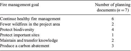
In Arnhem Land, fire is seen both as an asset to protect and utilise within the landscape, and as a threat to manage. All seven planning documents list fire as a key asset that Traditional Owners consider necessary for the health of their country. Conversely, uncontrolled wildfires are listed as a threat in all seven of the planning documents. In the five Healthy Country Plans, the threat of wildfire pertains to an average of over 75% of the other assets in the plan (range 45–100%). These include assets such as sacred sites, rock art, food and medicinal plants, animals and Anbinik (Allosyncarpia) forests, as well as the maintenance of healthy fire regimes (Warddeken Land Management Limited 2016; Arafura Swamp Rangers Aboriginal Corporation 2017; Mimal Land Management Aboriginal Corporation 2017).
Although Traditional Owners are undertaking fire management to satisfy several motivations, the compilation of fire management goals from the seven planning documents clearly demonstrates consistent themes. Indeed, six of the seven plans had the goal to continue healthy fire management and four of the plans to include protection of biodiversity (Table 2).
|
As with the fire management goals described previously, there were synergies across Arnhem Land in relation to fire management strategies and indicators, and their relationship to the broader fire management goals. The planning documents clearly illustrate that each fire management strategy relates to several fire management goals (Table 3). The single strategy that was consistent across all seven plans was that ‘Burning is directed by Traditional Owners’.

|
Savanna burning project outcomes
Using each strategy in Table 3 as a sub-heading, we describe and assess the outcomes from the operation of savanna burning projects in Arnhem Land using the indicators chosen by Traditional Owners as measures (Table 3). Where these indicators include remotely sensed fire metrics, we compare results between the baseline (pre-fire management) and during the fire operational project periods (see Table 1).
(a) Burning is directed by Traditional Owners
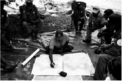
The first step in the annual fire management program is planning and consultation. Annually, each ranger program meets with Traditional Owners from the different clan groups within their operational area. This is an opportunity for Landowners and Djungkay to communicate how they would like to be involved in fire management and/or how they would like the rangers to care for their clan estates. Traditional Owners for each project area number in the thousands and, as a result, the ranger groups consult and plan with people who have the appropriate authority to approve, direct and be involved in the burning of country on their clan estates. In 2017, the average number of Traditional Owners consulted ranged between 72 and 88 per ranger program (ALFA (NT) Limited 2017, unpubl. data). Consultation and planning includes an evaluation of past fire histories using fire scar maps and the establishment of an operational plan for the upcoming burning season. This information is mapped and then forms the basis for prescribed burning routes (Fig. 2).
|
(b) Traditional Owners involved in delivery of fire management
Across Arnhem Land, Traditional Owners are involved in the delivery of fire management, both on-ground and aerial burning. During the planning process described previously, Traditional Owners can nominate who will burn their clan estates. This might include themselves, a family member or an Aboriginal ranger (who are Traditional Owners themselves). In 2017, the WALFA and Central Arnhem Land Fire Abatement (CALFA) projects recorded the formal engagement of 178 Traditional Owners (not including those formally employed as rangers through the ranger program) in the delivery of fire management. The average number of Traditional Owners engaged to undertake burning by each ranger group in the WALFA and CALFA project areas was 29.7 ± 6.8 (range 9–54). Typically, in regards to aerial-prescribed burning, a Traditional Owner will navigate at the front of the helicopter, while an Aboriginal ranger, trained as an incendiary machine operator, will manage the delivery of incendiaries (see Ansell and Koenig 2011 for further description).
(c) Continue strategic early dry season burning
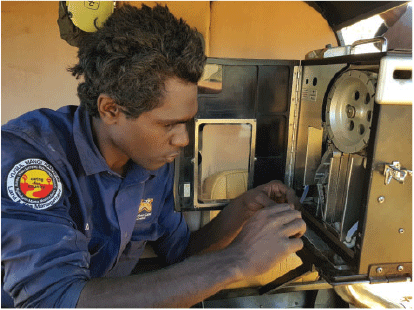
The fire projects in Arnhem Land predominantly use aerial-prescribed burning (incendiary pellets dropped from helicopters) during the early dry season to reduce fuel loads and establish a network of strategic burnt fire breaks across the landscape. This prevents the intrusion of fires from neighbouring lands and contains other fires within the project area. Given the large operational areas, these strategic breaks may be hundreds of kilometres long. Aerial burns are complemented by finer-scale ground burning from motor vehicles (4WD or quad bike), or by walkers using matches and drip torches to create more effective barriers, particularly around sensitive vegetation or cultural sites. Given the remote nature and vast fire project areas, many thousands of kilometres of aerial and ground burning are undertaken annually (Fig. 3, Table 4). The effort, in terms of kilometres travelled, is seasonally dependant and varies from year to year, enabling fire managers to respond to seasonal fire conditions (Table 4). For example, helicopters can fly at low speed and low height, allowing the Raindance machine operator to choose the delivery of capsules to suit weather conditions, vegetation types and fuel loads in order to vary the intensity of the resultant on-ground fire (Fig. 4).

|

|
|
Through fire management activities, the total area burnt has generally declined across the five projects, albeit non-significantly. However, these trends are defined by mostly significant (1) increases in area burnt during the early dry season (EDS), and (2) decreases in area burnt during the late dry season (LDS) (Fig. 5b, c). In all projects, the average EDS area in the baseline period was under 10% of the total project area and rises to an average of 11–32% during active fire management (Fig. 5b). Similarly, there is a marked change in burnt area size class distributions on commencement of active fire management in the project areas. For all project areas, relative to baseline years smaller fires have become more numerous (Fig. 5d) and longer unburnt areas appear to be increasing (Fig. 5e).

|
(d) Increase ground burning
The kilometres of ground burning using vehicles undertaken within each project area varies from year to year and between the project areas (Table 4). The total ground burning kilometres accounts for ~31% of all prescribed burning kilometres (Table 4). Over the period 2015–17, WALFA and CALFA projects demonstrate a range of ground burning effort between 1947% of total burning kilometres. Since it began in 2016, over 60% of all recorded burning kilometres in the North East Arnhem Land Fire Abatement (NEALFA) project are from ground burning. Conversely, the two South East Arnhem Land Fire Abatement (SEALFA) projects have very low recorded percentage of ground burning kilometres (<2%).
(e) Undertake late dry season fire suppression
Primarily undertaken within the WALFA and CALFA projects, wildfire suppression is becoming an increasingly applied fire management strategy. Over the last decade, rangers in Arnhem Land have adopted and refined a variety of firefighting tactics to suit the rugged and remote landscape. Back pack leaf blowers are deployed to create fire breaks and directly extinguish fires. Where access is possible, rangers can use ground-based vehicles to create fire breaks or fight fires. Where ground access is not possible, small teams of rangers are flown by helicopter and work their way around the active edge of the wildfire with the leaf blowers. These firefighting tactics rely on using existing landscape features and fire scars to support wildfire suppression.
Within 2017 alone, the WALFA and CALFA projects recorded wildfire suppression responses to 34 individual wildfires in the four-month period from 1st August – 31st November 2017. These comprised suppression of early dry season prescribed burns (8%); human induced roadside or hunting fires (67%) and lightening induced fire (23%). As a result of the combination of strategic early dry season burning and the late dry season wildfire suppression, the frequency of late dry season fires has reduced considerably across Arnhem Land (Fig. 6). The ten-year late fire frequency map from 2017 demonstrates an observed reduction in the area of red and yellow (areas with a high frequency of late fire) and an increase in the white and green areas (areas with no or little late fire in the ten-year period) compared with the previous ten-year period (Fig. 6).

|
(f) On country site protection, fire education and training events
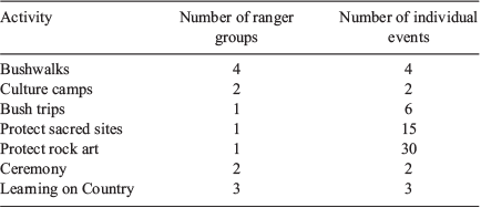
Annually, the ranger groups in Arnhem Land facilitate several other formalised fire management activities including bushwalks, culture camps and the protection of culturally important sites (e.g. rock art, sacred sites and Anbinik forests). In 2017, seven ranger groups within the fire project areas recorded 70 individual other activities related to fire, including integration with Learning on Country, the junior ranger program partnering with local schools (Table 5).
|
(g) Employment and training
The five registered ALFA fire projects in Arnhem Land are solely implemented by Aboriginal ranger groups. In 2017, the five registered fire projects recorded the employment of 316 Aboriginal people to undertake the actual burning and firefighting work.
The employment outcomes are considerably higher, when engagement in other fire activities are also taken into account such as fire planning and consultation. The WALFA project records employment and hours of engagement for the five main fire management works (see Table 6). Within the WALFA project, preseason consultation and planning as well as roadside burning and asset protection burning account for the highest number of staff employed as well as hours of employment (Table 6).

|
Even further employment is achieved with many groups investing carbon credit revenue into non-fire related land management employment (for examples see Jawoyn Association Aboriginal Corporation 2018; Warddeken Land Management Limited 2016; Mimal Land Management Aboriginal Corporation 2017).
(h) Strengthen participation in ALFA
Since the development of ALFA by the five Aboriginal ranger groups operating the WALFA project, the company has grown to register an additional four fire projects and support an additional four Aboriginal ranger groups in their engagement with the carbon market.
Annually, ALFA contracts and funds the ranger groups to undertake and report on operational activities associated with the fire projects. All of the engaged ranger groups also attend the pre, and post fire season meetings, attend producer group meetings and support logistics for the ALFA Board meetings.
(i) Operate successful carbon abatement project
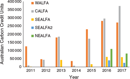
Every ALFA fire project has significantly reduced its emissions after ERF registration (Fig. 5f). However, the annual issuance of ACCUs demonstrates annual variation (Fig. 7). Prior to 2015, the fire projects demonstrated a biennial cycle of higher and lower abatement years. However, since 2015 the fire projects have achieved more consistency as well as an increase in the abatement of greenhouse gases. Of all the savanna burning projects listed on the ERF register, the five ALFA projects currently account for over 50% of the ACCU issuance under the method. The WALFA project currently accounts for the highest number of ACCUs issued to a single project across all eligible offsets projects across all methodologies (Commonwealth of Australia 2018a). Whilst actual carbon credit sales prices are confidential, using the current average ERF Auction price as a conservative value ($11.97 as at June 2018, (Commonwealth of Australia 2018a), sales of ALFA’s 2 668 848 ACCUs to date equates to well over AUD $31 million.
|
Discussion
Across 80 000 km2 in Arnhem Land, Aboriginal people are currently undertaking sophisticated fire management utilising customary fire knowledge. Fire management operations at this landscape scale is resource intensive and beyond the scope of ‘business as usual’ for Aboriginal ranger groups and Traditional Owners. It is important to acknowledge that many of the Aboriginal ranger programs in Arnhem Land are supported financially by the Australian Government through funding programs like Indigenous Protected Area (IPA) and Indigenous Advancement Strategy (IAS) as well as other sources of income, including philanthropy. However, in Arnhem Land it is the revenue derived from the sale of ACCUs that funds the savanna burning projects and enables its delivery in a way that is culturally responsive over such a vast scale. Clearly demonstrated in Fig. 5, the adoption of the savanna burning method has been the direct cause of the recent positive changes in fire management regimes in Arnhem Land. Although the WALFA project (with funded fire operations since 2006) demonstrates clear improvements during its retrospective fire operation period, fire regime metrics demonstrate further improvements with the additional funding provided through the generation and sale of ACCUs since 2015 (Fig. 5).
The results in this paper demonstrate that fire management across these landscapes is being undertaken to meet several environmental, cultural, social and economic goals. Of note is the recurring theme in the planning documents of fire management as an asset to be maintained in its own right on country. Broadly summarised into six key goals, their consistency further demonstrates how integral fire management is for Aboriginal people and their vision for country. The most frequent goal described in the planning documents was to ‘continue healthy fire management’. In itself, this goal is significant and reflects the success and progress of the fire management programs in Arnhem Land to date through the eyes of Traditional Owners. A previously intractable problem, how to reinstate Aboriginal fire management practices across a vast remote landscape, has in fact been solved. For the last decade, fire management programs, particularly in west and central Arnhem Land, have been delivering outstanding fire management results.
The goal to ‘continue healthy fire management’ also provides an opportunity to examine and describe what good fire management looks like for Aboriginal people in Arnhem Land. All of the eight planning documents detail the importance of Traditional Owners directing and undertaking fire management activities on their country. At the regional scale, the fire projects in Arnhem Land are owned and operated by Traditional Owners through the formation and operation of the ALFA Co. At the local scale, each Aboriginal ranger group is tasked to coordinate the planning and delivery of fire management with Traditional Owners. How this translates to fire management on the ground varies greatly from year to year and also from clan to clan across the landscape. As such, it is important for the savanna burning method to remain a mechanism to calculate and account for carbon given a range of management actions rather than prescribe a particular fire management regime. This is particularly relevant for Aboriginal Land under the Aboriginal Lands Rights Act because regardless of the project proponent, Traditional Owners have the right to burn their clan estates at any time.
The ALFA fire projects are clearly delivering strongly on their use of strategic fire management in the early dry season as well as their employment outcomes. The delivery of the suite of fire management activities provides a mix of employment opportunities for hundreds of Aboriginal people across Arnhem Land. As a result, in all project areas there is a significant change in the extent and seasonality of fire between the baseline and the fire project periods. In particular, project areas exhibit a significant decrease in the area of late dry season fire and a significant increase in the area of early dry season fires, which have also become smaller and more numerous (indicators of patchy fire) as a result of operating the fire projects.
Traditional Owners see on-ground burning as an important fine-scale fire tool, particularly for the management of specific food resources as well as cultural and environmental sites. Ground burning activities also maximise employment opportunities and, importantly, enable rangers to engage in the customary economic component of their individual and communal livelihoods (Buchanan and May 2012; Altman 2012). Altman (2012) described the high value placed by Aboriginal people on mobility and on accessing traditional lands given the significant lack of transport infrastructure in remote areas. It is also for this reason that ground burning is likely to be significantly underrepresented in the data, because it is often largely ad hoc.
Traditional Owners in Arnhem Land want fire management to result in fewer wildfires on their country. Indeed, this goal provided the impetus for the commencement of the WALFA project before the establishment of the savanna burning methods and Federal carbon legislation (Whitehead et al. 2009). In the fire-prone landscapes of northern Australia, large wildfires proliferate in the absence of fire management (Yibarbuk et al. 2001). The results in this paper related to wildfire ignition sources are similar to other such reports, where fires are lit mostly by people but are also ignited by lightning strikes during periods of extreme fire weather conditions before the start of the wet season (Yibarbuk et al. 2001). The joint strategies of reinstating customary fire regimes and active fire suppression across Arnhem Land through the operation of the fire projects has significantly reduced the average area burnt in the late dry season with a marked decline in both the extent and frequency of late dry season fire between the baseline and fire project periods (Figs 5, 6).
The protection and preservation of biodiversity, particularly plants and animals that are economically and culturally important to Aboriginal people (Altman 1987), is another key fire management goal in Arnhem Land. Within the planning documents, Traditional Owners identify species that are important indicators for healthy fire regimes including species such as emus, wallabies, native bees and fire sensitive plant communities like Anbinik (Allosyncarpia ternata) and the Callitris pine (Callitris intratropica) (Bawinanga Aboriginal Corporation 2015; Warddeken Land Management Limited 2016; Arafura Swamp Rangers Aboriginal Corporation 2017; Mimal Land Management Aboriginal Corporation 2017; Jawoyn Association Aboriginal Corporation 2018). Few publications have examined the response of these indicators to the changed fire regimes in Arnhem Land (Evans and Russell-Smith 2019; Woinarski et al. 2009), and some Aboriginal ranger groups in Arnhem Land have begun ambitious research and monitoring projects in order to be able to examine the biodiversity outcomes from their management regimes (e.g. Mayh Species Recovery Program; Warddeken Land Management Limited 2017).
The sandstone plateau of Arnhem Land and its surrounds supports an unusually high number of endemic plant and animal species, distinctive vegetation types and many threatened species (Woinarski et al. 2009). Ecological research in other parts of northern Australia provides some indication of the effectiveness of Arnhem Land fire regimes for the protection and preservation of this biodiversity hotspot. Werner and Peacock (2019) studied the population dynamics of open-forest savanna canopy trees (i.e. those trees that form the basic structure of the savannas and provide resources for associated fauna species) under various fire regimes. This research demonstrates that long-term persistence of savanna canopies with a non-sorghum understory are severely compromised by occasional late dry season fires. Werner and Peacock (2019) recommended that late dry season fires in these landscapes should be avoided where possible and otherwise not occur less than every five years.
Current research specifically focused on native fauna suggests that fire heterogeneity on a landscape scale is one of the most important factors, because not all animals respond the same way to fire regimes (Radford 2010; Lawes et al. 2015; Radford et al. 2015; Russell-Smith et al. 2017). Fire regimes that benefit savanna mammals are those that reduce the extent and frequency of severe wildfires and include the retention of areas of 3+ years of unburnt vegetation (Woinarski et al. 2011; Radford et al. 2015). Other important factors include the distribution of different-aged stands of vegetation, riparian areas, rainforest pockets, tree hollows and fruiting trees (Radford et al. 2015). In addition, fire also effects the interaction of native fauna with predators and this can have a marked effect on vertebrate biodiversity. Research in northern Western Australia demonstrates that feral cats are attracted to late fire scars within the landscape because their hunting is more effective in open country (Leahy et al. 2016). Although not a substitute for biodiversity monitoring, the results from research outside of Arnhem Land suggest that the contemporary fire regimes in Arnhem Land (which demonstrate a high level of patchiness, areas of unburnt vegetation and a reduction in the extent and frequency of late dry season fires) are likely to be favourable for a broad suite of existing biodiversity (e.g. Woinarski et al. 2011; Griffiths et al. 2015; Radford et al. 2015; Werner and Peacock 2019).
Within the planning documents, Traditional Owners state that they want the fire management projects to protect cultural sites as well as to maintain and transfer knowledge in relation to fire in the landscape. Although these goals are site specific to individual operational areas and outside the broad scope of this paper, it is likely that they are beginning to be met across Arnhem Land as a result of the reintroduction of people managing fire. Annual fire reports from each of the Aboriginal ranger groups in Arnhem Land describe the facilitation of specific larger fire-related events on country targeted at particular audiences (e.g. school kids and elders). These events included overnight bush walks and canoe trips on country, cultural camps in the school holidays, wildlife fire drives and ceremonies. For example, in 2016, Mimal Land Management Aboriginal Corporation and Arafura Swamp Rangers Aboriginal Corporation supported the performance of a fire ceremony that had not been performed for more than 40 years. All of these education and training events celebrate and share the knowledge of various uses of fire as directed by Traditional Owners.
The final of the six fire management goals is the production of a carbon abatement. Only three of the planning documents included this as a specific goal of their fire management. Although it is the production of a carbon abatement that provides the funding to operate the fire projects and associated cultural activities, this paper demonstrates that it does not drive decisions about how fire management is undertaken within the project areas. The ALFA projects are performing extremely well in regard to producing a carbon abatement under the savanna burning method (Fig. 7). This is likely to increase with the potential for the Arnhem Land projects to engage with new methodologies, particularly the recently released 2018 savanna burning sequestration and emissions avoidance methods (Commonwealth of Australia 2018b). Not surprisingly, it is the income generating potential of the fire projects that receives the most attention within the broader Australian community. A common misconception is that the savanna burning method pays people to burn and that, as a result, more country is burnt more often (Ray 2018). However, an abatement is only created when projects reduce the extent and severity of fire in the landscape compared with a historical baseline. As described above, the results from this paper clearly show a general decreasing trend in the total area burnt, a significant decrease in the area of late dry season fire and early dry season fires have become smaller and more numerous (indicators of patchy fire) as a result of operating the fire projects (Fig. 5).
Petty et al. (2015) asked how the fire management aspirations of Traditional Owners will continue to articulate with organisations such as ALFA (NT) Limited, which must remain responsive to the requirements and constraints of national greenhouse gas emissions frameworks and carbon abatement contracts. In Arnhem Land, successful operation focuses on local ownership of the fire management projects while utilising existing local Aboriginal ranger groups to coordinate delivery and engagement of Traditional Owners across large regional scales. Indeed, it is this structure that forms the framework for the governance of ALFA (NT) Limited. As noted by Altman (2012), Aboriginal rangers use local Indigenous ecological knowledge that they possess and mobilise from their relations with family living on outstations, who are their eyes on their country. The ranger groups have been developing their experience and expertise over many decades, supported by a diverse array of external partnerships as well as functional host organisations offering coordination, administration and financial management support. It is these complex and highly functional internal and external relationships that have enabled Traditional Owners in Arnhem Land to utilise their customary fire knowledge, navigate the administrative and methodological complexities of registering fire projects and subsequently reap the economic, cultural, social and environmental benefits of engaging with the developing carbon industry.
The compilation of ranger planning documents has proved an effective means of utilising existing and extensive information from Traditional Owners across a broad regional scale. However, we note that the views of all Traditional Owners will not be encapsulated within these plans and that this regional summary approach was not the original intention of the planning documents. Previous research highlights the importance of the need to monitor the effectiveness of large-scale fire management programs, particularly when there is a monetary incentive behind particular management actions (Fitzsimons et al. 2012). Fache and Moizo (2015) analysed the burning practice of Aboriginal rangers in south-east Arnhem Land before operation of a registered fire project. They described a transfer of the social and ritual responsibility of burning from Traditional Owners to Aboriginal rangers and other non-Aboriginal stakeholders and warn that this process risks producing fire regimes that respond to western expectations and not the dynamic relationships that Aboriginal peoples have with the environment. As such, the recent focus and investment in the development of the ranger planning documents is critical for maintaining Traditional Owner oversight of the local ranger programs. It also becomes an extremely useful tool to understand and evaluate the fire projects (as well as other aspects of land and sea management) from the viewpoint of Traditional Owners. Such an approach will also be critical to the development of other market based mechanisms in the natural and cultural resource management domain (e.g. carbon co-benefits, biodiversity credits and payment for environmental services; Jackson and Palmer 2015; Austin et al. 2018).
Conclusion
The development of savanna burning into an industry able to earn and sell carbon credits has not been met with a shift in public understanding of fire management, as summarised in a recent newspaper article (Ray 2018). Common critiques question not only the environmental outcomes of fire management (of which there is a growing body of both Aboriginal and western scientific evidence) but also the use and value of Aboriginal customary knowledge. This paper clearly communicates a description of contemporary fire management from the perspective of Traditional Owners across a broad region of fire project operation. In particular, this paper describes the aspirations of Traditional Owners and the importance of cultural responsibilities in relation to fire management. In Arnhem Land, Traditional Owners are making their own decisions about country and the use of fire as they have done for many thousands of years. In doing so, Traditional Owners are utilising the best tools available for undertaking the job and accessing cutting edge information and expertise through key partnerships (including with their local Aboriginal ranger programs), they are managing fire according to their intimate cultural and biophysical knowledge of country and continuing to share this knowledge with younger generations.
Conflicts of interest
The lead author is the CEO of ALFA (NT) Limited. ALFA is responsible for managing the savanna burning project reporting and the generation and sale of carbon credits from the Arnhem Land fire projects. ALFA was not involved in the consultation, compilation or publication of any of the ranger planning documents.
Acknowledgements
We thank the Traditional Owners throughout Arnhem Land, whose knowledge of, and vision for, country has been documented through the ranger planning documents, and for their ongoing oversight and support of the ranger programs. The Adjumarrlarl, Arafura Swamp, Djelk, Jawoyn, Mimal, Numbulwar Numburindi, Yugul Mangi, Warddeken and Yirralka ranger groups acknowledge the assistance of their many project partners who support, fund and contribute to the management of land and sea country in Arnhem Land. We thank Jon Altman, Jeremy Russell-Smith, Shaun Ansell, Ben Lewis and David Curmi, the Associate Editor and two anonymous reviewers for helpful comments on drafts of the manuscript. We also thank Alex Ernst and Jett Street for the use of their photographs. This research did not receive any specific funding.
References
Altman J (1987) ‘Hunter-gatherers today: an Aboriginal economy in northern Australia.’ (Australian Institute of Aboriginal Studies: Canberra, ACT, Australia)Altman J (2009) Manwurrk (fire drive) at Namilewohwo: a land-management, hunting and ceremonial event in western Arnhem Land. In ‘Culture, ecology and economy of fire management in North Australian savannas: rekindling the Wurrk tradition’. (Eds J Russell-Smith, P Whitehead, P Cooke) pp. 165–180. (CSIRO Publishing: Melbourne, Vic., Australia)
Altman J (2012) People on country as alternative development. In ‘People on country: vital landscapes, Indigenous futures’. (Eds J Altman, S Kerins) pp. 1–22. (The Federation Press: Sydney, NSW, Australia)
Altman J, Kerins S (2012) ‘People on country: vital landscapes, Indigenous futures.’ (The Federation Press: Sydney, NSW, Australia)
Altman JC, Buchanan GJ, Larsen L (2007) The environmental significance of the Indigenous estate: natural resource management as economic development in remote Australia. Centre for Aboriginal Economic Policy Research, Discussion Paper 286/2007. (Canberra, ACT, Australia)
Ansell S, Koenig J (2011) CyberTracker: an integral management tool used by rangers in the Djelk Indigenous Protected Area, central Arnhem Land, Australia. Ecological Management & Restoration 12, 13–25.
| CyberTracker: an integral management tool used by rangers in the Djelk Indigenous Protected Area, central Arnhem Land, Australia.Crossref | GoogleScholarGoogle Scholar |
Arafura Swamp Rangers Aboriginal Corporation (2017) ‘Arafura Swamp Rangers Healthy Country Plan 2017–2027.’ (Ramingining, NT, Australia)
Austin BJ, Robinson CJ, Fitzsimons JA, Sandford M, Ens EJ, Macdonald JM, Hockings M, Hinchley DG, McDonald FB, Corrigan C, Kennett R, Hunter-Xenie H, Garnett ST (2018) Integrated measures of Indigenous land and sea management effectiveness: challenges and opportunities for improved conservation partnerships in Australia. Conservation & Society 16, 372–384.
| Integrated measures of Indigenous land and sea management effectiveness: challenges and opportunities for improved conservation partnerships in Australia.Crossref | GoogleScholarGoogle Scholar |
Barber M, Jackson S (2017) Identifying and categorizing cobenefits in state-supported Australian indigenous environmental management programs: international research implications. Ecology and Society 22, 11
| Identifying and categorizing cobenefits in state-supported Australian indigenous environmental management programs: international research implications.Crossref | GoogleScholarGoogle Scholar |
Bawinanga Aboriginal Corporation (2015) ‘Djelk Healthy Country Plan 2015–2025.’ (Maningrida, NT, Australia)
Bureau of Meteorology (2018) West Arnhem weather. Available at http://www.bom.gov.au/places/nt/G6Z6/ [Verified 17 October 2019]
Buchanan G, May K (2012) Indigenous rangers and the customary economy. (The Federation Press: Sydney, NSW, Australia) Available at https://openresearch-repository.anu.edu.au/handle/1885/58300 [Verified 3 August 2018]
Capell A (1942) Languages of Arnhem Land, North Australia. Oceania 12, 364–392.
| Languages of Arnhem Land, North Australia.Crossref | GoogleScholarGoogle Scholar |
Clarkson C, Jacobs Z, Marwick B, Fullagar R, Wallis L, Smith M, Roberts RG, Hayes E, Lowe K, Carah X, Florin SA, McNeil1 J, Cox D, Arnold LJ, Hua Q, Huntley J, Brand HEA, Manne T, Fairbairn A, Shulmeister J, Lyle L, Salinas M, Page M, Connell K, Park G, Norman K, Murphy T, Pardoe C (2017) Human occupation of northern Australia by 65,000 years ago. Nature 547, 306–310.
| Human occupation of northern Australia by 65,000 years ago.Crossref | GoogleScholarGoogle Scholar | 28726833PubMed |
Commonwealth of Australia (2016) Australian Bureau of Statistics Census Data. Available at https://www.abs.gov.au/websitedbs/D3310114.nsf/Home/Census?OpenDocument&ref=topBar [Verified 17 October 2019]
Commonwealth of Australia (2017) Carbon Credits (Carbon Farming Initiative—Emissions Abatement through Savanna Fire Management) Methodology Determination 2015. Available at https://www.legislation.gov.au/Series/F2015L00344 [Verified 17 October 2019]
Commonwealth of Australia (2018a) Emissions Reduction Fund project register. Available at http://www.cleanenergyregulator.gov.au/ERF/project-and-contracts-registers/project-register [Verified 3 August 2018]
Commonwealth of Australia (2018b) Savanna fire management 2018 (sequestration and emissions avoidance). Available at http://www.environment.gov.au/climate-change/government/emissions-reduction-fund/methods/savanna-fire-management-2018-sequestration-emissions-avoidance [Verified 3 August 2018]
Commonwealth of Australia (2019) SavBAT, the Savanna Burning Abatement Tool. Available at https://savbat.environment.gov.au/ [Verified 3 August 2018]
Conservation Measures Partnership (2018) The open standards for the practice of conservation. Available at http://cmp-openstandards.org/ [Verified 3 August 2018]
Cooke PM (2009) Buffalo and tin, baki and Jesus: the creation of a modern wilderness. In ‘Culture, ecology and economy of savanna fire management in northern Australia: rekindling the Wurrk tradition’. (Eds J Russell-Smith, P Whitehead, P Cooke) pp. 69–84. (CSIRO Publishing: Melbourne, Vic., Australia)
Environmental Systems Research Institute (ESRI) (2016) ArcGIS Desktop: Release 10.5. (ESRI: Redlands, CA, USA)
Evans J, Russell-Smith J (2019) Delivering effective savanna fire management for defined biodiversity conservation outcomes: an Arnhem Land case study. International Journal of Wildland Fire
| Delivering effective savanna fire management for defined biodiversity conservation outcomes: an Arnhem Land case study.Crossref | GoogleScholarGoogle Scholar |
Fache E, Moizo B (2015) Do burning practices contribute to caring for Country? Contemporary uses of fire for conservation purposes in Indigenous Australia. Journal of Ethnobiology 35, 163–182.
| Do burning practices contribute to caring for Country? Contemporary uses of fire for conservation purposes in Indigenous Australia.Crossref | GoogleScholarGoogle Scholar |
Fitzsimons J, Russell-Smith J, James G, Vigilante T, Lipsett-Moore G, Morrison J, Looker M (2012) Insights into the biodiversity and social benchmarking components of the northern Australian fire management and carbon abatement programmes. Ecological Management & Restoration 13, 51–57.
| Insights into the biodiversity and social benchmarking components of the northern Australian fire management and carbon abatement programmes.Crossref | GoogleScholarGoogle Scholar |
Gambold N (2015) South East Arnhem Land Indigenous Protected Area – Plan of Management 2016–2021. (Northern Land Council: Darwin, NT, Australia) Available at https://www.nlc.org.au/uploads/pdfs/SEAL-IPA-PoM-V3.4.pdf [Verified 17 October 2019]
Garde M, Nadjamerrek LB, Kolkiwarra M, Kalarriya J, Djandjomerr J, Birriyabirriya B, Bilindja R, Kubarkku M, Biless P (2009) The language of fire: seasonality, resources and landscape burning on the Arnhem Land Plateau. In ‘Culture, ecology and economy of savanna fire management in northern Australia: rekindling the Wurrk tradition’. (Eds J Russell-Smith, PJ Whitehead, PM Cooke) pp. 85–164. (CSIRO Publishing: Melbourne, Vic., Australia)
Griffiths A, Garnett S, Brook B (2015) Fire frequency matters more than fire size: testing the pyrodiversity–biodiversity paradigm for at-risk small mammals in an Australian tropical savanna. Biological Conservation 186, 337–346.
| Fire frequency matters more than fire size: testing the pyrodiversity–biodiversity paradigm for at-risk small mammals in an Australian tropical savanna.Crossref | GoogleScholarGoogle Scholar |
Jacklyn P (2018) North Australia and rangelands fire information. Available at http://firenorth.org.au/nafi3/ [Verified 17 October 2019]
Jackson S, Palmer LR (2015) Reconceptualizing ecosystem services: possibilities for cultivating and valuing the ethics and practices of care. Progress in Human Geography 39, 122–145.
| Reconceptualizing ecosystem services: possibilities for cultivating and valuing the ethics and practices of care.Crossref | GoogleScholarGoogle Scholar |
Jawoyn Association Aboriginal Corporation (2018) ‘Jawoyn Healthy Country Plan 2018–2028.’ (Katherine, NT, Australia)
Lawes MJ, Murphy BP, Fisher A, Woinarski JCZ, Edwards AC, Russell-Smith J (2015) Small mammals decline with increasing fire extent in northern Australia: evidence from long-term monitoring in Kakadu National Park. International Journal of Wildland Fire 24, 712–722.
| Small mammals decline with increasing fire extent in northern Australia: evidence from long-term monitoring in Kakadu National Park.Crossref | GoogleScholarGoogle Scholar |
Laynhapuy Homelands Aboriginal Corporation (2017) ‘Laynhapuy Indigenous Protected Area Management Plan 2017–2022.’ (Yirrkala, NT, Australia)
Leahy L, Legge SM, Tuft K, McGregor HW, Barmuta LA, Jones ME, Johnson CN (2016) Amplified predation after fire suppresses rodent populations in Australia’s tropical savannas. Wildlife Research 42, 705–716.
| Amplified predation after fire suppresses rodent populations in Australia’s tropical savannas.Crossref | GoogleScholarGoogle Scholar |
Maraseni TN, Reardon-Smith K, Griffiths G, Apan A (2016) Savanna burning methodology for fire management and emissions reduction: a critical review of influencing factors. Carbon Balance and Management 11, 25
| Savanna burning methodology for fire management and emissions reduction: a critical review of influencing factors.Crossref | GoogleScholarGoogle Scholar | 27909461PubMed |
Markham F, Biddle N (2018) Income, poverty and inequality. Centre for Aboriginal Economic Policy Research Census Paper 2. (Canberra, ACT, Australia)
McMurray L, Foley R, O’Sullivan C (2018) An Indigenous ‘right way’ environmental, social and cultural core-benefits verification standard. Available at https://static1.squarespace.com/static/518cb4d9e4b082221e51d3b8/t/5b32ee4ef950b7530a12bd6f/1530064467248/AbCF+Edinburgh+2018+paper+public+March+2018.pdf [Verified 17 October 2019]
Mimal Land Management Aboriginal Corporation (2017) ‘Mimal Healthy Country Plan 2017–2027.’ (Weemol, NT, Australia)
Moorcroft H, Ignjic E, Cowell S, Goonack J, Mangolomara S, Oobagooma J, Karadada R, Williams D, Waina N (2012) Conservation planning in a cross-cultural context: the Wunambal Gaambera Healthy Country Project in the Kimberley, Western Australia. Ecological Management & Restoration 13, 16–25.
| Conservation planning in a cross-cultural context: the Wunambal Gaambera Healthy Country Project in the Kimberley, Western Australia.Crossref | GoogleScholarGoogle Scholar |
Petty AM, deKoninck V, Orlove B (2015) Cleaning, protecting, or abating? Making Indigenous fire management “work” in Northern Australia. Journal of Ethnobiology 35, 140–162.
| Cleaning, protecting, or abating? Making Indigenous fire management “work” in Northern Australia.Crossref | GoogleScholarGoogle Scholar |
R Core Team (2019) R: A Language and Environment for Statistical Computing. Version 3.6.1. (R Foundation for Statistical Computing: Vienna, Austria)
Radford IJ (2010) Fire regimes and regional biodiversity declines in north-west Australian tropical savannas? Review of knowledge and recommendations for future research. Conservation Science 7, 469–479.
Radford IJ, Gibson LA, Corey B, Carnes K, Fairman R (2015) Influence of fire mosaics, habitat characteristics and cattle disturbance on mammals in fire-prone savanna landscapes of the northern Kimberley. PLoS One 10, e0130721
| Influence of fire mosaics, habitat characteristics and cattle disturbance on mammals in fire-prone savanna landscapes of the northern Kimberley.Crossref | GoogleScholarGoogle Scholar | 26121581PubMed |
Ray C (2018) ‘There’ll be no park to preserve’: Australia’s fuming wildfire-control debate. The Sydney Morning Herald 12 January 2018. Available at https://www.smh.com.au/lifestyle/better-before-colonisation-north-australias-fuming-bushfirecontrol-debate-20171208-h015ys.html [Verified 23 February 2018]
Russell-Smith J, Whitehead PJ, Cooke PM (2009) ‘Culture, ecology and economy of savanna fire management in northern Australia: rekindling the Wurrk tradition.’ (CSIRO Publishing: Melbourne, Vic., Australia)
Russell-Smith J, Evans J, Edwards AC, Simms A (2017) Assessing ecological performance thresholds in fire-prone Kakadu National Park, northern Australia. Ecosphere 8, e01856
| Assessing ecological performance thresholds in fire-prone Kakadu National Park, northern Australia.Crossref | GoogleScholarGoogle Scholar |
Sangha K, Russell-Smith J, Morrison S, Costanza R, Edwards A (2017) Challenges for valuing ecosystem services from an Indigenous estate in northern Australia. Ecosystem Services 25, 167–178.
| Challenges for valuing ecosystem services from an Indigenous estate in northern Australia.Crossref | GoogleScholarGoogle Scholar |
Social Ventures Australia Consulting (2016) Social return on investment analysis of the Warddeken Indigenous Protected Area and associated Indigenous ranger programme. Report of the Department of Prime Minister and Cabinet, SVA Consulting. Available at https://www.socialventures.com.au/assets/Warddeken-SROI.pdf [Verified 20 February 2019]
Warddeken Land Management Limited (2016) ‘Warddeken Plan of Management 2016–2020.’ (Darwin, NT, Australia)
Warddeken Land Management Limited (2017) ‘Warddeken Land Management Limited Annual Report 2016–2017.’ (Darwin, NT, Australia)
Werner PA, Peacock SJ (2019) Savanna canopy trees under fire: long-term persistence and transient dynamics from a stage-based matric population model. Ecosphere 10, e02706
| Savanna canopy trees under fire: long-term persistence and transient dynamics from a stage-based matric population model.Crossref | GoogleScholarGoogle Scholar |
Whitehead PJ, Russell-Smith J, Cooke PM (2009) Fire management futures: new northern directions for environmental and socioeconomic benefit. In ‘Culture, ecology and economy of savanna fire management in northern Australia: rekindling the Wurrk tradition’. (Eds J Russell-Smith, P Whitehead, P Cooke) pp. 379–394. (CSIRO Publishing: Melbourne, Vic., Australia)
Woinarski J, Russell-Smith J, Andersen AN, Brennan K (2009) Fire management and biodiversity of the western Arnhem Land Plateau. In ‘Culture, ecology and economy of savanna fire management in northern Australia: rekindling the Wurrk tradition’. (Eds J Russell-Smith, P Whitehead, P Cooke) pp. 201–228. (CSIRO Publishing: Melbourne, Vic., Australia)
Woinarski J, Legge S, Fitzsimons J, Traill B, Burbidge A, Fisher A, Firth R, Gordon I, Griffiths A, Johnson C, McKenzie N, Palmer C, Radford I, Rankmore B, Ritchie E, Ward S, Ziembicki M (2011) The disappearing mammal fauna of northern Australia: context, cause and response. Conservation Letters 4, 192–201.
| The disappearing mammal fauna of northern Australia: context, cause and response.Crossref | GoogleScholarGoogle Scholar |
Yibarbuk D, Whitehead PJ, Russell-Smith J, Jackson D, Godjuwa C, Fisher A, Cooke P, Choquenot D, Bowman DMJS (2001) Fire ecology and Aboriginal land management in central Arnhem Land, northern Australia: a tradition of ecosystem management. Journal of Biogeography 28, 325–343.
| Fire ecology and Aboriginal land management in central Arnhem Land, northern Australia: a tradition of ecosystem management.Crossref | GoogleScholarGoogle Scholar |
1 Throughout this paper, we use the term Traditional Owner, to refer to both Traditional Aboriginal Owners, Aboriginal people who have inherited country from their father’s side (as defined in the Aboriginal Land Rights Act (Northern Territory) 1976), as well as Aboriginal people who have inherited management responsibilities for country on their mother’s side, called Djungkay in much of Arnhem Land.