

Extensive fires in Australia’s northern spinifex deserts – investigating the 2023 ‘Black Spring’ and the influence of indigenous fire management
Rohan Fisher A , Sarah Legge B C D * , Gareth Catt D and Hannah Cliff DA
B
C
D
Abstract
Climate change is increasing the incidence of extensive, severe fires in some regions. Extensive fires affected forested regions of Australia in 2019–2020 (Black Summer fires), attracting global attention. Australian deserts have experienced extensive fires for decades, following interruptions to traditional burning practices of Indigenous people. Unlike the Black Summer fires, desert fires receive little public attention.
We report the extent and spread of fire in Australia’s northern spinifex deserts in 2023, a year of extensive desert fire. Using two case studies, we also explore whether large-scale fire management programs by Indigenous rangers influenced these fires.
We used satellite imagery to collate fire extent and spread information across three northern spinifex desert bioregions (712,000 km2).
In 2023, 294,393 km2 (41.2%; versus annual average of 15%) burned, mostly in spring (September–November), following high rainfall. Fires sometimes spread rapidly, covering >25,000 km2 in 5 days. Where large-scale fire management had occurred, fire spread was interrupted by areas burnt previously in prescribed fires.
The deserts are prone to extensive fires after high rainfall, but large-scale fire management affects how fires spread.
Large-scale desert fire management is relatively recent but shows promise for limiting the size and impacts of desert fires.
Keywords: desert fire, fire management, indigenous ranger, megafire, satellite imagery, spinifex desert, wildfire.
Introduction
Fire is a natural ecological disturbance factor in many ecosystems worldwide (He et al. 2019). Nevertheless, marked disruptions to fire regimes can be problematic even in fire-adapted ecosystems, if the new fire regime has characteristics that exceed the bounds within which species and ecosystems evolved (Whelan 1995). Disruptions in fire frequency, severity and season caused by habitat loss, fragmentation and degradation, changes to anthropogenic ignition patterns, and now changes in climate, are contributing to species declines (Kearney et al. 2019; Bowman et al. 2020b; Legge et al. 2023) and ecosystem collapse (Bergstrom et al. 2021). Fire regime changes include an increasing incidence of extremely extensive, severe fires (Linley et al. 2022).
Despite the fact that fire is especially prevalent in many Australian ecosystems (Murphy et al. 2019), large areas of habitat are being deleteriously affected by extensive, severe fires. A textbook case of such fires in Australia occurred during the ‘Black Summer’ of 2019–2020, when over 100,000 km2, or almost 20% of the eastern and southern temperate and subtropical forests burnt (Legge et al. 2023). Over the previous 18 years, the average annual fire extent in these forests had been just 2% (Bowman et al. 2020a). These fires caused substantial conservation detriment to many species (Gallagher et al. 2021; Marsh et al. 2021; Legge et al. 2022) and elicited an outpouring of concern from the general public (van Eeden et al. 2020; Rumpff et al. 2023). The proximity of the Black Summer fires to the most heavily populated parts of Australia raised the profile of their impacts on people as well as natural environments, leading to international media coverage. The Black Summer fires herald an uncharted future of increasing frequency of intense and extensive fires in Australian forests (Nolan et al. 2020; Canadell et al. 2021). However, fire regimes are also changing in other biomes that are further from the public eye and therefore receive less public and scientific attention.
Most fire in Australia occurs in the tropical savannas and desert biomes (Murphy et al. 2013). This is true even for the 2019–2020 season, when 200,000 km2 (mostly in the tropical savannas, but also in woodlands and desert) burnt in addition to the 100,000 km2 of the temperate and subtropical forests (Bowman et al. 2020a). The potential for extensive fire in savannas and deserts depends largely on ground fuel availability, which in turn depends largely on accumulated rainfall since the last fire (Murphy et al. 2013; Ruscalleda-Alvarez et al. 2023). In the tropical savannas of northern Australia, the annual monsoon reliably causes large rainfall totals during each year’s wet season (600 to >1000 mm), resulting in grass growth and thus fuel loads that can carry fires every 1–3 years during the intervening dry seasons. Moving south through the deserts, the influence of the monsoon weakens and the average annual rainfall decreases (from 600 to <200 mm pa), becomes less seasonal, and as a result the frequency of fire diminishes (Murphy et al. 2013; van Etten and Burrows 2018). While rainfall in most Australian deserts is low on average, they do experience irregular episodes of widespread, prolonged rainfall, linked to global climate cycles (Verhoeven et al. 2020). These rainfall events drive a pulse of growth in the grass layer that readily carries fire at the end of the next dry season, when dry lightning strikes are common. Desert fire regimes therefore includes periods where these prolonged rainfall events provide the pre-requisite conditions for extensive fires (Edwards et al. 2008; Turner et al. 2011).
The fire regimes associated with rainfall patterns in the tropical savannas and desert were modified for many thousands of years by the traditional burning practices of Indigenous people, who used fire intensively for purposes such as signalling, ceremony, clearing access, hunting and promoting food and medicinal plants (Yibarbuk et al. 2001; Pike 2008; Vaarzon-Morel and Gabrys 2009). In the tropical savannas, progressive burning throughout the year tended to stop the spread of fire later in the dry season. In the deserts, burning practices created fine-scale patchworks of vegetation in different stages of regrowth post-fire. There was probably geographic and temporal variation in where traditional fire practices occurred (Kimber and Friedel 2015), and their effect on the fire regime (Wright et al. 2021). Nevertheless, the outcomes of traditional fire practice on desert vegetation can clearly be seen in aerial photos of the western and northwestern deserts from the 1940s and 1950s, indicating that Aboriginal inhabitants still living a traditional lifestyle actively burned large areas (Burrows et al. 2006; Bliege Bird et al. 2020; Blackwood et al. 2022). Traditional fire practice continues around some small remote desert communities, and fire patterns at these sites resemble those evident from the historical photos (Bliege Bird et al. 2012, 2018; Paltridge et al. 2025).
As Indigenous people across northern and central Australia moved off their traditional lands into missions, towns, settlements and pastoral stations between ~1870 and 1980, traditional fire management practices waned. Fires became more extensive, frequent and severe (Russell-Smith et al. 2009; Legge et al. 2011; Paltridge et al. 2025), contributing to biodiversity loss (Woinarski et al. 2011; Legge et al. 2023). The deterioration of fire regimes has been arrested and reversed in many parts of northern Australia during the last 15 years, as large-scale fire management programs have emerged, particularly on Indigenous lands (Edwards et al. 2021). These programs seek to achieve interlinked social, cultural and conservation objectives, and are facilitated by greenhouse gas reduction offsets (Ansell and Evans 2019; Evans and Russell-Smith 2019). They have caused a marked reduction in the extent of uncontrolled fire and encouraged more pyro-diverse landscapes (Perry et al. 2016; Wysong et al. 2022; Vigilante et al. 2024).
Large-scale fire management programs have developed more slowly in the desert, partly because there is currently no access to emissions reduction payments (Wysong et al. 2022). Despite this disadvantage, large-scale fire management has been expanding from some nuclei sites (Ruscalleda-Alvarez et al. 2023). The management is driven by biocultural priorities but is carried out by Indigenous rangers, blending traditional understandings of landscape/fire interactions with contemporary methods including aerial incendiaries dropped from aircraft and satellite technology. In the northern deserts, rainfall is higher and more strongly seasonal because of the influence of the monsoon, and prescribed burning typically occurs in March/April, soon after the summer wet season. Rainfall is lower (on average) and less seasonal in more southern deserts and prescribed burning typically occurs during the cool winter months (June–August). This program of fire regime change includes fine-scale ground burning around sensitive areas, including culturally significant sites and habitats of threatened species such as bilbies Macrotis lagotis, night parrots Pezoporus occidentalis and great desert skinks Liopholis kintorei (Ngururrpa Rangers et al. 2024; Paltridge et al. 2025; Southwell et al. 2025). However, the essential feature of the program is to burn Country (a term signifying all aspects of the land and its living things, and the knowledge, cultural practices and responsibilities related to them) in a controlled way, to break up large areas of vegetation that are at the same stage of post-fire recovery. This ensures that wildfires cannot spread evenly across these areas when temperatures and winds rise later in the dry, hot season (September–November).
The outcomes of this large-scale fire management in Australian deserts that applies traditional knowledge but uses contemporary methods are still poorly reported, because most fire programs are recent relative to average fire return intervals (6–30 years). Evaluations of some of the first programs to start (around 2010) do suggest a shift in fire patterns (Ruscalleda-Alvarez et al. 2023). However, many programs started more recently; for example, in the Great Sandy Desert, ranger groups began large-scale burning around 2019 (e.g. Legge et al. 2024; Ngururrpa Rangers et al. 2024).
Widespread and prolonged rain occurred in Australia’s northern deserts and some parts of the low rainfall tropical savannas during 2022–2023 (BoM 2024). The rain caused biomass accumulation that resulted in very extensive desert fires in the following dry season (June–November 2023). Despite their size, and their potential impacts on cultural and biodiversity values, they were not acknowledged as a significant national event. In this paper, we describe the extent of the 2023 northern desert fires, and their relationship to lightning strikes. We also examine fire spread patterns to explore whether the emerging, large-scale fire management programs being delivered by ranger groups in one part of these northern deserts influenced the fires.
Methods
To explore whether the 2023 fires in the northern desert were unusual, we used satellite imagery to examine the fire patterns in three large desert bioregions through a 23-year time series, and to compare the 2023 fires in the northern deserts to the fire patterns in the adjacent topical savannas in the same year. We sourced information on lightning ground strikes to explore the likelihood that extensive fires will occur, when fuel conditions allow. Finally, using a case study approach, we examine the fire occurrence and spread of the two most extensive fires, which occurred in regions with contrasting levels of prescribed burning by Indigenous rangers.
Study area
This study focuses on the Great Sandy Desert, Tanami, and Davenport Murchison Ranges bioregions, which together cover 712,000 km2, and encompass most of northern spinifex deserts (Fig. 1a). Their ecosystems are dominated by spinifex Triodia spp. hummock grasslands with areas of shrubland (Acacia spp., Grevillea spp., Hakea spp.) and scattered trees (Corymbia spp., Eucalyptus spp., Owenia reticulata, Allocasuarina decaisneana), occasionally intersected by paleodrainage lines and dry salt lakes (Thackway and Cresswell 1997). The climate of these bioregions is hot and arid. The average annual rainfall grades from 600 mm in the north, to 200 mm in the south. Most rain (>90%) falls in the wet season (December–March). In 2023, these bioregions experienced ‘very much above average’ rainfall deciles in the period mid-2022 to mid-2023 (BoM 2024) (Fig. 1b).
(a) The study area showing the burnt area extent in 2023 in grey; the tropical savanna bioregions (green) (and in which the high and low rainfall zones are either side of the >1000 m isohyet (blue)); and the three northern spinifex desert bioregions (red), Great Sandy Desert (1), Tanami (2) and Davenport Murchison Ranges (3). (b) The blue shading shows the ‘very much above average’ rainfall deciles in the period mid-2022 to mid-2023 (BoM 2024). The grey shading underlaid shows areas burnt in 2023. (c) The two case study fires (in black) within the three northern spinifex desert bioregions (in grey outline). Regional population centres are also shown.
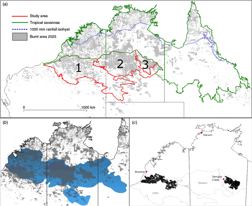
To provide context, we also assess the 2023 fire extent of the tropical savanna bioregions to the north, considering both the high rainfall (>1000 mm) and lower rainfall zones (>600, <1000 mm) (Fig. 1a). The tropical savannas are mostly comprised of tall open forests to open woodlands, with smaller areas of grassland. Within this matrix, wetland, riparian, rainforest pocket and heathland ecosystems occur in smaller areas.
Satellite based assessment of annual fire extent
Annual fire extent data were obtained from the North Australia Fire Information (NAFI) service (http://firenorth.org.au) which provides 250 m resolution fire mapping based on the Moderate Resolution Imaging Spectroradiometer (MODIS) (Fisher and Edwards 2015). The available annual fire extent mapping (2000–2023) is attributed with the year and month burnt. For every year in the 2000–2023 time series, we calculated the fire extent in each of the three desert bioregions, and the adjacent low- and high-rainfall savannas. We overlaid each year’s fire extent to create a single layer in 2023 that showed the year of the last fire. From this, we calculated the area of different ‘time-since-fire’ classes of vegetation at the start and end of 2023, i.e. before and after the occurrence of the desert fires.
Lightning strikes
Lightning ground strike records were obtained from the Vaisala lightning network. The Vaisala operates a long range lightning detection network using very low frequency and low frequency sensors to detect lightning by monitoring the electromagnetic waves produced during a lightning discharge. This network is particularly good for identifying lighting in remote locations distant from sensors. The data obtained include location, date and flash type (ground strike, cloud flash). Cloud flashes that do not touch the ground typically outnumber ground strike flashes by a factor of four, so distinguishing cloud flashes from ground strikes that could cause ignition is critical. These data were converted into a raster format and resampled to produce a 500 m × 500 m lightning frequency grid over the most active storm (and fire) months from September–November 2023.
Case study: the effects of Indigenous ranger burning programs
We extracted two of the largest single fire events of 2023, one from the Great Sandy Desert bioregion (where large-scale Indigenous ranger burning occurs) and the other from the Davenport Murchison Ranges bioregion (where Indigenous ranger burning is limited) for closer inspection (Fig. 1c). Bioregions differ in many environmental attributes, but one of the key differences between these two bioregions is their fire management histories. We inspected patterns of fire spread by enhancing the temporal precision of when fires occurred by overlaying daily hot-spot data (from MODIS and National Oceanic and Atmospheric Association (NOAA) satellites; accessed from NAFI) to the MODIS-derived burnt areas, and attributing each pixel with the date of burn. Using the polygon buffer tool in ARC GISPro, we added a 10 km buffer around the burnt area boundaries and intersected these polygons with fuel age. We calculated the areas within the fire extent, and the fire extent plus buffer, that had been burnt 0–1, 2–4, and >4 years before the 2023 fire.
Results
Fire extent
Fires burnt 294,393 km2 (41.2%) of the Great Sandy Desert, Tanami and Davenport Murchison Ranges bioregions in 2023, or roughly three times the fire extent of the Black Summer fires in eastern and southern Australia (Legge et al. 2023). Over the 2000–2023 time series, the average annual fire extent was 15%. The 2023 fire extent was the second largest area burnt through the 24-year mapped period, surpassed only by the 2011 fire extent (Fig. 2). The three desert bioregions show pulses of high fire extents in 2000–2002, 2011–2012, and 2023, each following widespread, above-average rainfall caused by La Niña weather conditions (Fig. 2).
The proportion burnt (orange bars) and the rainfall (blue) for each year, between 2000 and 2023, for the three northern spinifex desert bioregions (Great Sandy Desert (GSD), Tanami (TAN) and Davenport Murchison Ranges (DMR) separately and together, as well as the tropical savannas (high and low rainfall zones).
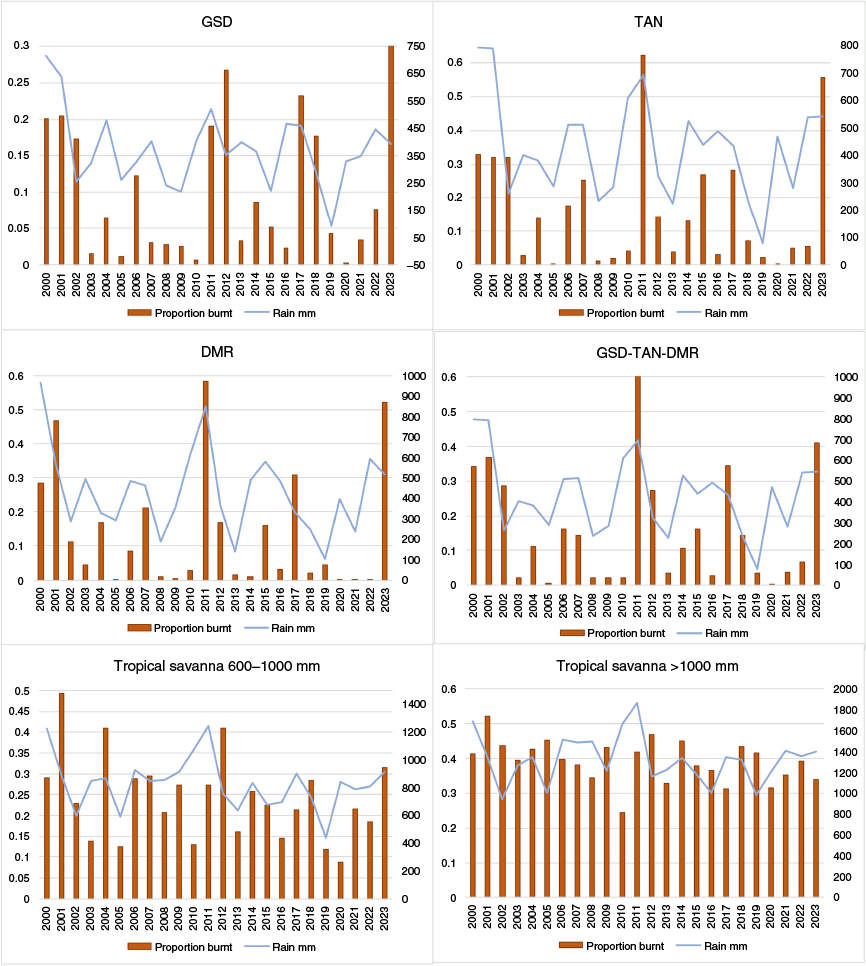
In the low-rainfall (600–1000 mm) tropical savannas, the average annual fire extent over the 2000–2023 time series was 24%. Similarly to the desert bioregions, fire extent in the tropical savannas also pulsed upwards in 2000–2001, 2011–2012, but less dramatically in 2023 (31.3% burned), despite high preceding rainfall in some areas. In the high-rainfall savannas the fire extents have been more even across years; the 2023 fire extent (33.8%) was the seconded lowest in the time series after 2017 (Fig. 2).
Fire event timing
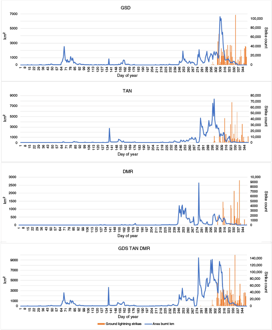
Across all three northern spinifex desert bioregions, fires occurred sporadically between March–August, covering small areas (Fig. 3). Fire activity began to increase from early September, noticeable first in the Davenport Murchison Ranges. From mid-late September through to November, fire extent across the desert bioregions increased markedly. Over 75% (218,967 km2) of the year’s fire extent in the three desert bioregions burnt in 60 days before 18 November 2023. Periods of higher winds and temperatures led to the most rapid fire spread. For example, in early November, 27,732 km2 (23% of the total) of the Great Sandy Desert burnt in just 5 days. In the Tanami, 29,928 km2 (20% of the total) burnt in 5 days from the 22 October (Fig. 3).
Ground strike lightning records
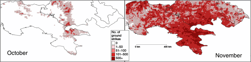
The Vaisala lightning network recorded over 1,138,000 ground strikes over the three northern spinifex desert bioregions between September–November. Of these, 25,810 strikes occurred across the Great Sandy Desert and Tanami bioregions in October, and over 1 million in November (Figs 3, 4). This overlapped with the period of the greatest fire extent in both bioregions. In contrast, Davenport Murchison Ranges experienced very little lightening until November, after most of the burning had already occurred, when 30,943 ground strikes were recorded.
Case studies
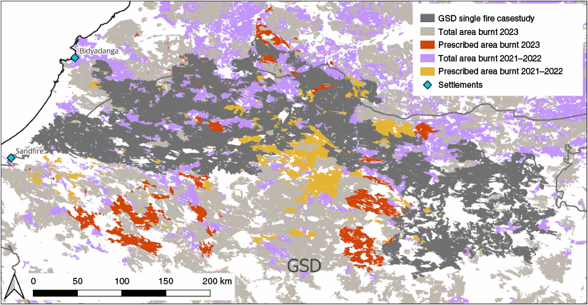
Two of the largest single fire events in the three northern spinifex desert bioregions in 2023 are investigated as case studies (Fig. 1c). The area east of Tennant Creek in the Davenport Murchison Ranges has experienced little prescribed burning in previous years (R. Fisher, pers. comm.). In contrast, much of the Great Sandy Desert bioregion has experienced large-scale prescribed burning since 2019. For example, in 2022–2023, Indigenous rangers dropped over 115,000 incendiaries over this area (H. Cliff, pers. comm.) (Fig. 5).
Outcomes of prescribed burning (in orange and red) by the Nyangumarta, Karajarri, Nyikina Mangala and Ngurrara Rangers in the Great Sandy Desert (GSD), over 2021–2023. Grey lines are the bioregion boundaries. The 2023 fires are shown in grey, with the case study fire in darker grey.
The fire in the Great Sandy Desert (one ignition) burnt over 41,800 km2 (10.5% of the bioregion, and 35% of the overall 2023 fire extent in the bioregion) (Fig. 6a). Starting in the northeast, near the Canning Stock Route, this fire burnt for >50 days from early September to late October, travelling over 600 km (in a straight line) before meeting other fires near the coast, south of Broome. Fire spread mostly occurred over areas that were last burnt in 2017 or before; conversely, fire spread was usually prevented in areas burnt between 2021 and earlier in 2023 (Fig. 6b).
Final extent and spread of fires in the (a) Great Sandy Desert and (c) Davenport Murchison Ranges case studies. The year of the previous fire (0 (burned earlier in 2023) to 11 years prior) in (b) Great Sandy Desert and (d) Davenport Murchison Ranges. The outline of the fires is shown by a black line; a 10 km buffer has been added around the perimeters so that the year of previous burns where the 2023 fires stopped is visible.
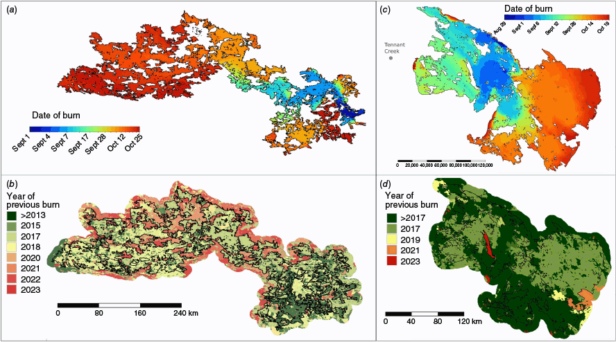
The fire (two ignitions) in the Davenport Murchison Ranges bioregion burnt 25,000 km2 (43% of the bioregion, and 82% of the overall 2023 fire extent in the bioregion) (Fig. 6c). This fire burnt for >60 days from early August to mid October. Whilst starting in, and mostly affecting, the Davenport Murchison Ranges bioregion, the fire also burnt >200 km east from its starting point into the eastern Tanami bioregion. Again, fire spread occurred in older time-since-fire areas (2017 and older) but appeared to be limited in the few areas burnt in 2021 and early 2023 (Fig. 6d).
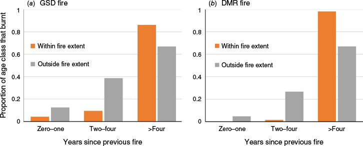
Overall, most of the area burnt in both fires had been burnt more than 4 years before (Fig. 7). In each fire, the buffer around the fire boundary contained vegetation that burnt relatively more recently (Fig. 7). However, the fire spread in these two cases studies differed markedly, in that the Great Sandy Desert fire was continually blocked and re-routed by patches of vegetation that had been burnt in earlier fires between 2017 and early 2023 (Fig. 6b). This ‘stuttering’ spread pattern was not evident in the Davenport Murchison Ranges bioregion, where patches burned between 2017 and early 2023 were rare (Fig. 6d).
For each of the (a) Great Sandy Desert (GSD) and (b) Davenport Murchison Ranges (DMR) bioregions, the graphs show the proportions of the 2023 fire extent that covered areas that had last burnt 0–1, 2–4, and >4 years before the 2023 fire. The orange bars show the values from within the fire extent boundary; the grey bars show the values including the 10 km buffer around the fire extent boundary.
Discussion
The collation of annual fire extents across the three bioregions that cover the northern spinifex deserts show that extensive fire in the late dry season (September–November) made 2023 one of the biggest fire years in the northern deserts since 2000 (Fig. 2). Over 40% of the three bioregions burned, well above the annual average of 15%. The total area burned exceeded 294,000 km2, which is triple the area burned (100,000 km2) in the eastern and southern forests during the Black Summer fires (Legge et al. 2022). The desert fires moved extremely quickly at times, for example covering over 25,000 km2 in 5 days, on two occasions. Despite their cumulative size, the 2023 desert fires barely registered in the national media. The limited media that did occur focussed on the threat of fire to the town of Tennant Creek in the Northern Territory (e.g. Dick 2023; Spina-Matthews 2023) but most Australians are likely unaware of the existence or scale of these fires.
Fire risk in spinifex deserts increases substantially after periods of widespread, prolonged rainfall (Edwards et al. 2008; Turner et al. 2011; Ruscalleda-Alvarez et al. 2023). These rainfall conditions happen episodically, usually every 5–10 years (van Etten and Burrows 2018). In the year leading up to the 2023 fires, the northern spinifex deserts experienced ‘very much above average’ rainfall (Fig. 1b) which caused a rapid increase in spinifex biomass and greater fuel connectivity. Local land managers and regional fire authorities were aware of the impact of this rain on spinifex biomass and thus fire risk, with a senior fire agency spokesperson warning of impending, extensive fires in the Northern Territory (Hislop 2023).
Our analysis of lightning data shows that, given the sheer volume and density of ground strikes, ignitions are inevitable; therefore, when sufficient spinifex biomass and fuel connectivity exists, extensive fires are to be expected. The 2023 desert fires stimulated some discussion in the local media of the role of arson in starting the fires (Ellis 2023). Reducing human ignitions in the late dry season is important and should be approached through community engagement and education. However, even without arson there are multiple and widespread ignitions from lightning strikes, and once started, continuous high fuel loads mean that fires will spread extensively.
Despite the repeated and predictable confluence of rainfall, high spinifex biomass and lightning, we suggest that extensive desert fires are not inevitable. The case study comparison of fire occurrence and spread in the Great Sandy Desert versus the Davenport Murchison Ranges bioregions demonstrates the influence that prescribed burning can have on fire outcomes. Since 2019, Indigenous ranger teams in the Great Sandy Desert have conducted large-scale prescribed burning annually, at the end of the wet season (March–May). These intentional burns affected the progression of wildfire in late 2023, when compared to the wildfire in the Davenport Murchison Ranges (Fig. 6), where prescribed burning in previous years had been much more limited (Fig. 3). These differences are not caused by differences in topography or vegetation mosaics – one of the characteristics of the Great Sandy desert bioregion is the homogeneity of its spinifex sand dunes and plains (Thackway and Cresswell 1997).
In the northern savannas, annual, large-scale prescribed burning programs over the past 10–20 years have transformed fire patterns by reducing fire size, frequency and severity of fire, and smoothing out fluctuations in fire extents between years, including in 2023 (Fig. 2, Ansell and Evans 2019; Evans and Russell-Smith 2019; Wysong et al. 2022; Vigilante et al. 2024). Achieving this result in deserts, which has lower and more variable rainfall, is challenging partly because the level of prescribed burning effort required will vary substantially between years, making work planning difficult. In particular, the prescribed burning effort needed after prolonged, widespread rainfall across the huge areas involved, is daunting. Whereas fire managers might burn about 5% of their management area in a year with average rainfall, after high rainfall, they may need to increase their effort 5–10 fold over a short period with attendant logistic hurdles and costs. Finally, road access for aviation fuel drops and crew exchanges is extremely constrained in the desert. Nevertheless, after just a few years of work, the rangers of the Great Sandy Desert have made a measurable difference to wildfire spread. With ongoing refinement of their prescribed burning delivery, they are likely to increasingly modify overall fire patterns, including after above-average rainfall years. For example, the prevailing winds in the late dry season are southeasterly, as shown by the direction of fastest fire spread in Fig. 6a. Strategic fire breaks, aligned north-south, may help limit the spread of future wildfires.
For millenia, Indigenous traditional fire practices markedly influenced the desert fire regime (Burrows et al. 2006; Bliege Bird et al. 2020; Blackwood et al. 2022). Changes to fire regimes occurred during the 20th century, as people moved off Country and Indigenous burning practices were interrupted. The loss of these fire practices may have contributed to biodiversity losses in the desert (Legge et al. 2023). For Indigenous custodians, restoring intentional burning is fundamental for improving spiritual and cultural, as well as environmental, health (Vaarzon-Morel and Gabrys 2009; Robinson et al. 2021, 2023). Large-scale fire management is likely to become increasingly challenging: climate change projections for the northern deserts suggest higher and more variable rainfall (CSIRO and Bureau of Meteorology 2022), which may increase the frequency of conditions that trigger extensive fire. However, the case study we present here suggests that supporting Indigenous rangers to restore fire practices using contemporary methods could have a substantial effect on desert fire patterns and may limit the extent and damage caused by fires in the northern spinifex desert.
Data availability
Data can be downloaded from the North Australia Fire Information service (https://www.firenorth.org.au/nafi3/).
Declaration of funding
S. L. is supported by Australian Research Council LP220200184. G. C. and H. C. are supported by the Indigenous Desert Alliance.
Acknowledgements
We thank the Nyikina Mangala, Karajarri, Ngurrara and Nyangumarta Rangers for allowing us to refer to their fire management programs, and for all the work that they do. We acknowledge their past and present elders, and their ongoing custodianship of Country.
References
Ansell J, Evans J (2019) Contemporary Aboriginal savanna burning projects in Arnhem Land: a regional description and analysis of the fire management aspirations of Traditional Owners. International Journal of Wildland Fire 29(5), 371-385.
| Crossref | Google Scholar |
Bergstrom DM, Wienecke BC, van den Hoff J, Hughes L, Lindenmayer DB, Ainsworth TD, Baker CM, Bland L, Bowman DM, Brooks ST, Canadell JG, Constable AJ, Dafforn KA, Depledge MH, Dickson CR, Duke NC, Helmstedt KJ, Holz A, Johnson CR, McGeoch MA, Melbourne-Thomas J, Morgain R, Nicholson E, Prober SM, Raymond B, Ritchie EG, Robinson SA, Ruthrof KX, Setterfield SA, Sgrò CM, Stark JS, Travers T, Trebilco R, Ward DFL, Wardle GM, Williams KJ, Zylstra PJ, Shaw JD (2021) Combating ecosystem collapse from the tropics to the Antarctic. Global Change Biology 27(9), 1692-1703.
| Crossref | Google Scholar | PubMed |
Blackwood EMJ, Karajarri Rangers , Bayley S, Biljarni H, Fensham R, Lindsay M, Noakes E, Wemyss J, Legge S (2022) Pirra Jungku: comparison of traditional and contemporary fire practices on Karajarri Country, Western Australia. Ecological Management & Restoration 23, 83-92.
| Crossref | Google Scholar |
Bliege Bird R, Codding BF, Kauhanen PG, Bird DW (2012) Aboriginal hunting buffers climate-driven fire-size variability in Australia’s spinifex grasslands. Proceedings of the National Academy of Sciences 109(26), 10287-10292.
| Crossref | Google Scholar |
Bliege Bird R, Bird DW, Fernandez LE, Taylor N, Taylor W, Nimmo D (2018) Aboriginal burning promotes fine-scale pyrodiversity and native predators in Australia’s Western Desert. Biological Conservation 219, 110-118.
| Crossref | Google Scholar |
Bliege Bird R, McGuire C, Bird DW, Price MH, Zeanah D, Nimmo DG (2020) Fire mosaics and habitat choice in nomadic foragers. Proceedings of the National Academy of Sciences 117(23), 12904-12914.
| Crossref | Google Scholar |
BoM (2024) ‘Recent and historical rainfall maps.’ (Australian Government Bureau of Meteorology: Australia) Available at http://www.bom.gov.au/climate/maps/rainfall/?variable=rainfall&map=decile&period=12month®ion=nat&year=2023&month=07&day=31
Bowman D, Williamson G, Yebra M, Lizundia-Loiola J, Pettinari ML, Shah S, Bradstock R, Chuvieco E (2020a) Wildfires: Australia needs national monitoring agency. Nature 484, 188-191.
| Crossref | Google Scholar |
Bowman DMJS, Kolden CA, Abatzoglou JT, Johnston FH, van der Werf GR, Flannigan M (2020b) Vegetation fires in the Anthropocene. Nature Reviews Earth & Environment 1(10), 500-515.
| Google Scholar |
Burrows ND, Burbidge AA, Fuller PJ, Behn G (2006) Evidence of altered fire regimes in the Western Desert region of Australia. Conservation Science Western Australia 5(3), 14-26.
| Google Scholar |
Canadell JG, Meyer C, Cook GD, Dowdy A, Briggs PR, Knauer J, Pepler A, Haverd V (2021) Multi-decadal increase of forest burned area in Australia is linked to climate change. Nature Communications 12(1), 6921.
| Crossref | Google Scholar | PubMed |
Dick S (2023) Bushfire breaches containment lines near Tennant Creek, as authorities work to protect NT town. ABC News. Available at https://www.abc.net.au/news/2023-09-13/containment-lines-breached-tennant-creek-barkly-bushfire-nt/102848686?utm_campaign=abc_news_web&utm_content=link&utm_medium=content_shared&utm_source=abc_news_web [verified 13 September 2023].
Edwards G, Allan G, Brock C, Duguid A, Gabrys K, Vaarzon-Morel P (2008) Fire and its management in central Australia. The Rangeland Journal 30(1), 109-121.
| Crossref | Google Scholar |
Edwards A, Archer R, De Bruyn P, Evans J, Lewis B, Vigilante T, Whyte S, Russell-Smith J (2021) Transforming fire management in northern Australia through successful implementation of savanna burning emissions reductions projects. Journal of Environmental Management 290, 112568.
| Crossref | Google Scholar | PubMed |
Ellis V (2023) NT land managers demand action on deliberately lit fires as 13 million hectares burnt. ABC News. Available at ABC News (2023) Aust. Broadcast. Corp. Available at https://www.abc.net.au/news/rural/2023-11-02/13m-hectares-burnt-nt-bushfires-some-deliberately-lit/103044152
Evans J, Russell-Smith J (2019) Delivering effective savanna fire management for defined biodiversity conservation outcomes: an Arnhem Land case study. International Journal of Wildland Fire 29(5), 386-400.
| Crossref | Google Scholar |
Gallagher RV, Allen S, Mackenzie BD, Yates CJ, Gosper CR, Keith DA, Merow C, White MD, Wenk E, Maitner BS (2021) High fire frequency and the impact of the 2019–2020 megafires on Australian plant diversity. Diversity and Distributions 27(7), 1166-1179.
| Crossref | Google Scholar |
He T, Lamont BB, Pausas JG (2019) Fire as a key driver of Earth’s biodiversity. Biological Reviews 94(6), 1983-2010.
| Crossref | Google Scholar | PubMed |
Hislop J (2023) Northern Territory to see worst bushfire season in more than a decade due to high fuel loads. ABC News. Available at https://www.abc.net.au/news/2023-08-14/worst-fire-season-in-a-decade-expected-for-northern-territory/102726614
Kearney SG, Carwardine J, Reside AE, Fisher DO, Maron M, Doherty TS, Legge S, Woinarski JCZ, Garnett SG, Wintle BA, Watson JEM (2019) The threats to Australian imperiled species. Pacific Conservation Biology 25, 231-244.
| Crossref | Google Scholar |
Kimber R, Friedel M (2015) Challenging the concept of Aboriginal mosaic fire practices in the Lake Eyre Basin. The Rangeland Journal 37(6), 623-630.
| Crossref | Google Scholar |
Legge S, Murphy S, Kingswood R, Maher B, Swan D (2011) EcoFire: restoring the biodiversity values of the Kimberley region by managing fire. Ecological Management and Restoration 12, 84-92.
| Crossref | Google Scholar |
Legge S, Rumpff L, Woinarski JCZ, Whiterod NS, Ward M, Southwell DG, Scheele BC, Nimmo DG, Lintermans M, Geyle H, Garnett ST, Hayward-Brown B, Ensbey M, Ehmke G, Ahyong ST, Blackmore CJ, Bower DS, Brizuela-Torres D, Burbidge AH, Burns PA, Butler G, Catullo R, Chapple DG, Dickman CR, Doyle K, Ferris J, Fisher D, Gallagher R, Gillespie GR, Greenlees MJ, Hohnen R, Hoskin CJ, Hunter D, Jolly C, Kennard M, King A, Kuchinke D, Law B, Lawler I, Lawler S, Loyn R, Lunney D, Lyon J, MacHunter J, Mahony M, Mahony S, McCormack RB, Melville J, Menkhorst P, Michael D, Mitchell N, Mulder E, Newell D, Pearce L, Raadik TA, Rowley J, Sitters H, Spencer R, Valavi R, West M, Wilkinson DP, Zukowski S (2022) The conservation impacts of ecological disturbance: time-bound estimates of population loss and recovery for fauna affected by the 2019–2020 Australian megafires. Global Ecology Biogeography 31, 2085-2104.
| Crossref | Google Scholar |
Legge S, Rumpff L, Garnett ST, Woinarski JCZ (2023) Loss of terrestrial biodiversity in Australia: magnitude, causation, and response. Science 381, 622-631.
| Crossref | Google Scholar | PubMed |
Legge S, Bijlani H, Karajarri Rangers , Ngurrara Rangers , Taylor B, Shovellor J, McCarthy F, Murray C, Ala’i J, Brown C, Tromp K, Bayley S, Noakes E, Wemyss J, Cliff H, Jackett N, Greatwich B, Corey B, Cowan M, Macdonald K, Murphy B, Banks S, Lindsay M (2024) Pirra Jungku, Pirra Warlu: using traditional fire practice knowledge and contemporary science to guide fire management goals for desert animals. Wildlife Research 51, WR24069.
| Crossref | Google Scholar |
Linley GD, Jolly CJ, Doherty TS, Geary WL, Armenteras-Pascual D, Belcher C, Bliege Bird R, Duane A, Fletcher M, Giorgis MA, Haslem A, Jones GM, Kelly LT, Lee CKF, Nolan RH, Parr CL, Pausas J, Price JN, Regos A, Ritchie EG, Ruffault J, Williamson GJ, Wu Q, Nimmo DG (2022) What do you mean, ‘megafire’? Global Ecology and Biogeography 31, 1906-1922.
| Crossref | Google Scholar |
Murphy BP, Bradstock RA, Boer MM, Carter J, Cary GJ, Cochrane MA, Fensham RJ, Russell‐Smith J, Williamson GJ, Bowman DM (2013) Fire regimes of Australia: a pyrogeographic model system. Journal of Biogeography 40(6), 1048-1058.
| Crossref | Google Scholar |
Murphy BP, Prior LD, Cochrane MA, Williamson GJ, Bowman DM (2019) Biomass consumption by surface fires across Earth’s most fire prone continent. Global Change Biology 25(1), 254-268.
| Crossref | Google Scholar | PubMed |
Ngururrpa Rangers , Sunfly C, Schubert A, Reid AM, Leseberg N, Parker L, Paltridge R (2024) Potential threats and habitat of the night parrot on the Ngururrpa Indigenous Protected Area. Wildlife Research 51(10), WR24083.
| Crossref | Google Scholar |
Nolan RH, Boer MM, Collins L, Resco de Dios V, Clarke H, Jenkins M, Kenny B, Bradstock RA (2020) Causes and consequences of eastern Australia’s 2019–20 season of mega‐fires. Global Change Biology 26(3), 1039-1041.
| Crossref | Google Scholar | PubMed |
Paltridge R, Napangati Y, Ward Y, Nangagee J, James M, Olodoodi R, Napangati N, Eldridge S, Schubert A, Blackwood E, Legge S (2025) The relationship between the presence of people, fire patterns and persistence of two threatened species in the Great Sandy Desert. Wildlife Research 52, WR24076.
| Crossref | Google Scholar |
Perry JJ, Vanderduys EP, Kutt AS (2016) Shifting fire regimes from late to early dry-season fires to abate greenhouse emissions does not completely equate with terrestrial vertebrate biodiversity co-benefits on Cape York Peninsula, Australia. International Journal of Wildland Fire 25(7), 742-752.
| Crossref | Google Scholar |
Robinson C, Costello O, Lockwood M, Pert PL, Garnett ST (2023) Empowering Indigenous leadership and participation in wildfire recovery, cultural burning and land management. In ‘Australia’s 2019–20 Megafires: Biodiversity Impacts and Lessons for the Future’. (Eds L Rumpff, S Legge, S van Leeuwen, B Wintle, JCZ Woinarski) pp. 430–441. (CSIRO Publishing: Melbourne, Australia)
Ruscalleda-Alvarez J, Cliff H, Catt G, Holmes J, Burrows N, Paltridge R, Russell-Smith J, Schubert A, See P, Legge S (2023) Right-way fire in Australia’s spinifex deserts: an approach for measuring management success when fire activity varies substantially through space and time. Journal of Environmental Management 331, 117234.
| Crossref | Google Scholar | PubMed |
Southwell DM, Moore D, McAlpin S, Blackwood EM, Schubert A, Smart AS, Merson SD, Goumas M, Macgregor NA, Paltridge RM (2025) Fire regimes drive population trends of a threatened lizard in the central and western deserts of Australia. Wildlife Research 52(4), WR24135.
| Crossref | Google Scholar |
Spina-Matthews S (2023) Tennant Creek bushfire threat level downgraded to advice, with residents urged to remain vigilant. ABC News. Available at https://www.abc.net.au/news/2023-09-15/barkly-bushfire-nt-tennant-creek-containment-lines-smoke-health/102858118?utm_campaign=abc_news_web&utm_content=link&utm_medium=content_shared&utm_source=abc_news_web
Thackway R, Cresswell ID (1997) A bioregional framework for planning the national system of protected areas in Australia. Natural Areas Journal 17(3), 241-247.
| Google Scholar |
Turner D, Lewis M, Ostendorf B (2011) Spatial indicators of fire risk in the arid and semi-arid zone of Australia. Ecological Indicators 11(1), 149-167.
| Crossref | Google Scholar |
Vaarzon-Morel P, Gabrys K (2009) Fire on the horizon: contemporary Aboriginal burning issues in the Tanami Desert, central Australia. GeoJournal 74(5), 465-476.
| Crossref | Google Scholar |
Verhoeven EM, Murray BR, Dickman CR, Wardle GM, Greenville AC (2020) Fire and rain are one: extreme rainfall events predict wildfire extent in an arid grassland. International Journal of Wildland Fire 29(8), 702-711.
| Crossref | Google Scholar |
Vigilante T, Goonack C, Williams D, Joseph A, Woolley L-A, Fisher R (2024) Factors enabling fire management outcomes in Indigenous Savanna fire management projects in Western Australia. International Journal of Wildland Fire 33(9), WF24092.
| Crossref | Google Scholar |
Woinarski JCZ, Legge S, Fitzsimons JA, Traill BJ, Burbidge AA, Fisher A, Firth RSC, Gordon IJ, Griffiths AD, Johnson CN, McKenzie NL, Palmer C, Radford I, Rankmore B, Ritchie EG, Ward S, Ziembicki M (2011) The disappearing mammal fauna of northern Australia: context, cause, and response. Conservation Letters 4(3), 192-201.
| Crossref | Google Scholar |
Wright BR, Laffineur B, Roye D, Armstrong G, Fensham RJ (2021) Rainfall-linked megafires as innate fire regime elements in arid Australian spinifex (Triodia spp.) grasslands. Frontiers in Ecology and Evolution 9, 296.
| Crossref | Google Scholar |
Wysong M, Legge S, Clarke A, Maier S, Bardi Jawi Rangers , Nyul Nyul Rangers , Yawuru Country Managers , Cowell S, Mackay G (2022) The sum of small parts: changing landscape fire regimes across multiple small landholdings in north-western Australia with collaborative fire management. International Journal of Wildland Fire 31, 97-111.
| Crossref | Google Scholar |
Yibarbuk D, Whitehead PJ, Russell-Smith J, Jackson D, Godjuwa C, Fisher A, Cooke P, Choquenot D, Bowman D (2001) Fire ecology and Aboriginal land management in central Arnhem Land, northern Australia: a tradition of ecosystem management. Journal of Biogeography 28(3), 325-343.
| Crossref | Google Scholar |