

Evaluating the shifts in rainfall and pasture-growth variabilities across the pastoral zone of Australia during 1910–2010
David H. Cobon A C , Louis Kouadio A , Shahbaz Mushtaq A , Chelsea Jarvis A , John Carter B , Grant Stone B and Peter Davis A
A Centre for Applied Climate Sciences, University of Southern Queensland, West Street, Toowoomba, Qld 4350, Australia.
B Ecosciences Precinct, Department of Environment and Science, Queensland Government, Boggo Road, Brisbane, Qld 4102, Australia.
C Corresponding author. Email: David.Cobon@usq.edu.au
Crop and Pasture Science 70(7) 634-647 https://doi.org/10.1071/CP18482
Submitted: 17 October 2018 Accepted: 02 May 2019 Published: 5 August 2019
Journal Compilation © CSIRO 2019 Open Access CC BY-NC-ND
Abstract
Interannual rainfall variability in Australia is a source of risk within agricultural industries. Insights into changes to rainfall and pasture-growth variabilities are essential to inform adaptation strategies for climate risk management within the grazing industry. We investigated shifts in rainfall and pasture-growth variabilities between the periods 1910–1960 and 1961–2010 for the pastoral zone in Australia. Rainfall variability was also assessed for the high-rainfall and wheat–sheep zones. An index of variability was calculated by using gridded rainfall and pasture-growth data for both periods. The percentage change was then calculated as the difference in variation between the two periods. Overall, the variability of annual rainfall has significantly increased (P < 0.01) between the two periods for the pastoral zone. Pastoral regions in the Northern Territory had the greatest increases in pasture-growth variability, with 62–85% of the area affected by a significant increase in variability. Between the periods 1910–1960 and 1961–2010 across the wheat–sheep zone, annual rainfall variability significantly decreased (P < 0.01), with 70% of the area having a negative change, whereas for the high-rainfall zone, the variability did not change significantly. Monitoring ongoing trends in rainfall and pasture-growth variability is important to inform strategic grazing management. Management practices to mitigate the impacts of increased variability in pastoral regions are discussed.
Additional keywords: climate variability, climate effects on pasture systems.
Introduction
Australia experiences the most variable interannual rainfall regime in the world (Ropelewski and Halpert 1987; Nicholls and Wong 1990; Love 2005). This variability is a major driver of crop and pasture production (i.e. spatially and seasonally) and has important impacts on farmers’ incomes, regional communities, and the Australian economy overall (McKeon et al. 2004; Potgieter et al. 2013; Reardon-Smith et al. 2017).
The interannual variability of rainfall in Australia has been linked to variability in strength and frequency of coupled oceanic–atmospheric systems, often referred to as climate drivers, which occur at widely varying temporal (seasonal, annual, decadal and multi-decadal) and spatial scales (Meinke and Stone 2005; Risbey et al. 2009). Considering time-scales that are relevant from an agricultural management perspective, the known climate drivers that contribute to rainfall variability in Australia include the Madden–Julian Oscillation (Madden and Julian 1971; Wheeler et al. 2009); the El Niño–Southern Oscillation (ENSO) (Ropelewski and Halpert 1987; Nicholls 1988; Philander 1990; Allan et al. 1996; Allan 2000); the Quasi-biennial Oscillation (Lindesay 1988); the Southern Annular Mode (SAM) (Thompson and Wallace 2000; Hall and Visbeck 2002; Hendon et al. 2007), also known as the Antarctic Oscillation; fluctuations in the latitude and intensity of the subtropical ridge (Pittock 1975; Williams and Stone 2009); the Decadal and Interdecadal Pacific Oscillations (Power et al. 1999; Allan 2000; Folland et al. 2002; Meinke et al. 2005; Henley et al. 2015); the Indian Ocean Dipole (IOD) (Nicholls 1989; Saji et al. 1999); fluctuations in the longwave pattern (Risbey et al. 2009); and the Anthropogenic Global Warming (Timmermann et al. 1999; Nicholls 2004; Dai 2011).
The broad-scale Australian agricultural zones (i.e. pastoral, high-rainfall and wheat–sheep zones; Fig. 1) are affected by more than one driver and the combined influence of these drivers on rainfall varies seasonally and geographically across these zones. Climate drivers in Australia are not independent of each other, and the teleconnections between the drivers can intensify or dampen their individual impact on climate (Risbey et al. 2009). For instance, rainfall in northern Australia is highly seasonal, with the bulk occurring during austral summer (December–February) in the active phase of the Australian monsoon, which is related to the position of the inter-tropical convergence zone (ITCZ) (Nicholls et al. 1982). Other synoptic events such as tropical cyclones, subtropical ridges, thermal lows outside the ITCZ, and meso-scale convection also influence this region, although to a lesser extent. Arid regions further from the coast also receive most of their rainfall in summer owing to several convective events including the incursion of the monsoon trough, north-west cloud bands, and upper-level low-pressure systems. In the temperate regions, the key rain-bearing synoptic systems are low-pressure and frontal systems, east-coast cyclones, atmospheric blocking and the resultant cut-off lows (Risbey et al. 2009). In regions of south-easterrn Australia, rainfall in autumn, winter and spring is influenced by multiple drivers (e.g. ENSO, IOD, SAM and blocking; Risbey et al. 2009). Although various Australia regions can be subject to its influence, the Madden–Julian Oscillation predominantly affects the monsoonal rains in the north (Risbey et al. 2009; Wheeler et al. 2009).

|
Pastoral areas cover ~70% of Australia (Australian State of the Environment Committee 2001) (Fig. 1), and occupy major components of the equatorial, tropical, grassland and desert climate zones (Peel et al. 2007). The grazing industry is the second largest sub-sector within Australian agricultural production in terms of industry value-add (MLA 2017). The climatology of Australia’s grasslands is based on the three primary grazing regions: the tropical zone (tropical and subtropical grasslands, savannahs and shrublands), the arid centre (deserts and xeric shrublands), and the temperate zone (temperate grasslands, savannahs and shrublands). The rainfall characteristics of each of the key grazing regions differ enormously and vary from a summer-dominant rainfall zone in the north to a winter-dominant zone in the southern-most regions. Areas north of ~30°S either have austral warm-season-dominant rainfall or are in arid regions with low and highly variable annual rainfall.
Rainfall deficiencies resulting from high variability often lead to water-deficit stresses, which can cause severe reductions in pasture growth, development and survival, depending on the severity of the stress and the growth stage at which the stress occurs. Thus, the high year-to-year variability in rainfall has long been a major source of risk in pastoral management and financial performance and a contributing factor in resource degradation (McKeon et al. 2004; Cobon et al. 2017).
Climate variability on a regional scale, and trends in that variability over the last 50 years, are expected to have impacts on agriculture policy and farm-management practices (Love 2005). Improving the understanding of rainfall variability would serve to inform adaptation and resilience across agricultural regions prone to more variabilities in rainfall and pasture growth, which could facilitate longer term climate-change adaptation by incrementally shifting farm and agribusiness management practices according to the climate forecasts. The aim of this study was to evaluate the shifts in rainfall and pasture-growth variabilities between the periods 1910–1960 and 1961–2010 across the pastoral agricultural zone in Australia. For comparison, rainfall variability was also assessed for the high-rainfall and wheat–sheep zones. The results of such study are crucial because they provide insightful information for region-specific management decisions and policies for crops and grazing industries.
Materials and methods
Data
Gridded daily rainfall data (0.05° × 0.05°, ~5 km2 at the equator) based on weather-station data were sourced from the Australian Bureau of Meteorology (BOM) for the 1910–2010 period for use in this study (http://www.bom.gov.au/climate/data-services/maps.shtml). The spatial distribution of rainfall stations considered in this study is presented in Fig. 2. Areas with limited coverage were masked and not considered in the analyses. Regions masked included the eastern part of Western Australia (WA); the north-western part of South Australia (SA); and north-eastern, south-eastern and south-western parts of Northern Territory (NT).

|
Monthly pasture-growth data at 0.05° × 0.05° resolution were sourced from the Queensland Department of Environment and Science, Australia, for the 1910–2010 period. Pasture growth was defined as new plant material (aboveground parts) produced during the period being considered (i.e. month). The growth included all grassy species and annual broad-leafed plants (tussock bases and grass stolons were not considered). The AussieGRASS Environmental Calculator (Carter et al. 2000; DSITI 2013) was used to sum daily calculations to estimate monthly and annual totals, with annual totals being calculated from May to April. AussieGRASS is a modelling framework based on the GRASP (grass production) model (Rickert et al. 2000). The model includes data layers of climate information (rainfall, temperature, solar radiation, humidity, evaporation and vapour-pressure deficit; Jeffrey et al. 2001), soils, pasture types, tree cover and stock numbers, calibrated by using remote-sensing satellite greenness data and data from extensive ground truthing across the country (Carter et al. 2003; Hassett et al. 2006). Tree density and CO2 were held constant in the analysis. Limitations in the model include the inability to represent some growth-limiting processes (e.g. heat-stress death of new growth, tussock death in extreme or protracted droughts), impacts of long-term soil erosion, loss of infiltration capacity, and changes in species composition. Also, the model generally better estimates growth in the drier periods than in wetter times (Carter et al. 2000; Rickert et al. 2000).
Index of variability and percentage changes in rainfall and pasture-growth variations
In order to determine the percentage changes in rainfall and pasture-growth variability between the periods 1910–1960 and 1961–2010, the index of variability (IV) was calculated, following the percentile-analysis method adopted by BOM (http://www.bom.gov.au/jsp/ncc/climate_averages/rainfall-variability/index.jsp). The 12-month totals of rainfall (or pasture growth) for each grid cell were calculated from May to April. Then, the IV for each grid cell for each of the defined periods 1910–1960 (IV1910–1960) and 1961–2010 (IV1961–2010) was calculated as follows:

This index varies from low to extreme. The different IV classes were: low (IV <0.50), low–moderate (0.50–0.75), moderate (0.75–1.00), moderate–high (1.00–1.25), high (1.25–1.50), very high (1.50–2.00), and extreme (IV >2.00). The formula and IV classes presented here are in alignment with BOM conventions.
The difference in variation between the two periods was then calculated as follows:

Thus, a positive difference in variation would indicate that the IV has increased between the two periods, and a negative value would indicate that it has decreased.
A visual analysis of changes in rainfall variability between the two defined periods 1910–1960 and 1961–2010 for selected grids (as case studies) was investigated by using density distribution functions.
Statistical analyses
A paired-samples t-test was carried out based on the proportions of land area (expressed in pixel counts) for each IV class for each of the agricultural zones and regions, to check whether the difference in areas between the two defined periods was significant. Given the number of IV classes (n = 7), a normality test was performed beforehand, using the Shapiro–Wilk normality test, to check whether the differences for the pairs follow a normal distribution. Then, the paired-samples t-test was applied for normal distributions. For data that were not normally distributed, the paired two-samples Wilcoxon test was used. Additionally, with regard to the agricultural regions, an analysis of variance was performed to determine whether the proportion of land area in each IV class was significantly different between the two periods, using a Fisher’s least significant difference test. To determine the statistical difference between the proportions of land area with positive and negative percentage change for each of the agricultural zones and regions, a one-proportion Z-test was used. A significance level of P = 0.05 was used for all statistical tests.
All of the spatial analyses were performed with ArcGIS Desktop version 10.5 (ESRI 2016). The maps were produced by using the Geocentric Datum of Australia 1994 (ESRI 2016) coordinate system to display the data. The R Programming language (R Foundation for Statistical Computing, Vienna) was used for data analysis and plotting purposes.
Results
The IV (hereinafter referred to as RV and PGV for rainfall and pasture growth, respectively) and the percentage change in variability between the two periods are presented first for the agricultural zones (pastoral, high-rainfall and wheat–sheep zones), and then for the agricultural regions within these zones (12 regions in the pastoral zone, eight in the high-rainfall zone, and 12 in the wheat–sheep zone) (Fig. 1).
Note, in case of pasture growth, that although the PGV and percentage change were computed for all of Australia, only the results for the pastoral agricultural zone and regions within will be presented and discussed, because GRASP was developed to model the growth of tropical and subtropical native pastures in the northern Australia pastoral areas, and is less well parameterised for temperate climates characterised by the high-rainfall and wheat–sheep zones in southern Australia (Rickert et al. 2000).
Patterns of rainfall variability, 1910–1960 and 1961–2010
Rainfall variability during 1910–1960 and 1961–2010 for the agricultural zones
Across the pastoral zone, RV was moderate to extreme during both periods (Fig. 3a, b), with 57% of the area having an index value >1 in 1910–1960 and 65% in 1961–2010 (Table 1). RV values were low to moderate in the majority of the high-rainfall and wheat–sheep zones. Nil or few areas were affected by high, very high or extreme RV for both zones (proportion of area <1%, Table 1). Comparison of proportion of land area in each RV class between the two periods for the high-rainfall and wheat–sheep zones showed contrasting results in terms of values, but they were not statistically different (P > 0.05). For the pastoral zone (Fig. 4a), extreme RV affected a similar proportion of land area in the two periods 1910–1960 and 1961–2010, whereas moderate–high and high RV increased between these periods. For the high-rainfall and wheat–sheep zones, land areas with low–moderate RV were largest among the RV categories in both periods, and there was no statistical difference between the two periods (P > 0.05; Fig. 4c, d).

|

|

|
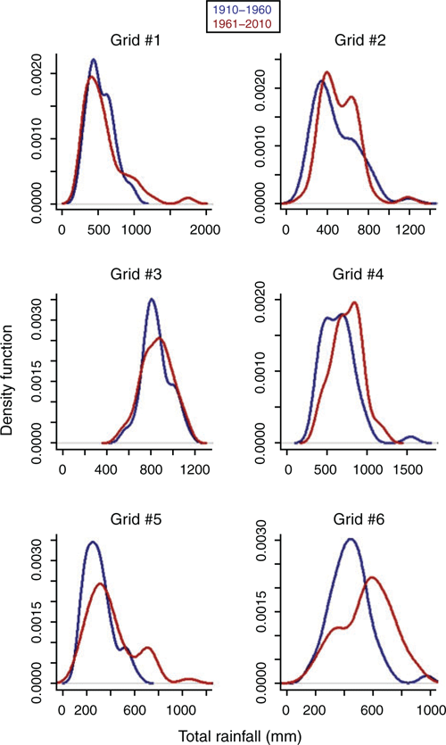
The density-distribution functions of total rainfall during 1910–1960 and 1961–2010 for selected areas across the agricultural zones (Table 2, Fig. 5) show that for regions such as Queensland (Qld) Cape York and the Gulf (Q:CY) (grid #1) or NT Barkly Tablelands (N:BT) (grid #5) and WA Kimberley (W:K) (grid #6) where there was in increase in RV, the alteration in the variability seemed to be linked to more wet extremes of rainfall during 1961–2010 (Fig. 5). In regions such as New South Wales (NSW) West Slopes and Plains (NS:NW) (grid #4), the decrease in RV during 1961–2010 could be related to the combined decreases in the wet end, and more events centred near the mean rainfall value.

|
|
Percentage change of annual rainfall variability for the agricultural zones
Analysis of percentage change revealed a significant (P < 0.01) increase in annual RV for 56% of the pastoral-zone land area between the periods 1910–1960 and 1961–2010 (Table 3). Areas with the greatest increases in variability (percentage change >80%) in this zone were in north-western Qld and north-eastern and central regions of NT (Fig. 3c). Unlike the pastoral zone, a significant (P < 0.01) decrease in annual RV was observed for 70% of the land areas included in the wheat–sheep zone (Table 3). For the high-rainfall zone, the proportions of land areas that experienced positive or negative percentage change between the two periods were statistically similar (P > 0.05).

|
The predominant percentage change over the two defined periods was observed within the range +20% to −20% for all three agricultural zones, there was a minimal negative percentage change in RV below −40% regardless of the agricultural zone (Fig. 6a). The pastoral zone had 25% of its area with positive percentage change of RV >20%, and 16% of its area having a percentage change ranging from +20% to +40%.

|
Rainfall variability for the agricultural regions
Agricultural regions in the pastoral zone
For three of four agricultural regions in the pastoral zone in NT, land areas with low, low–moderate or moderate RV decreased between the periods 1910–1960 and 1961–2010, whereas areas with moderate–high or high RV increased. For example, land areas with moderate RV in N:BT decreased in proportion by ~53% between periods 1910–1960 and 1961–2010, whereas those with moderate–high and high RV increased by 10% and 36%, respectively (Supplementary Materials table S1, available at the journal’s website). In NT Top End Darwin (N:TE), the RV was mostly low (52–65% of the area with an index value <0.5 in both periods), and the shift was mainly from low–moderate RV towards low RV. Note that, in N:TE, more than half of the area in the east was not considered in the analysis because of insufficient rainfall climate-station coverage; the actual pattern may therefore be different in the eastern parts of the region.
For agricultural regions in the pastoral zone in Qld, namely Q:CY and Qld Central North (Q:CN), a shift from low–moderate or moderate RV to moderate–high or high RV was also observed between the two periods (Supplementary Materials table S1 and fig. S1). In Qld Charleville–Longreach (Q:CL) and Qld West and South West (Q:WS), the opposite occurred, with areas with moderate–high or high RV decreasing and areas of low–moderate or low RV increasing between periods 1910–1960 and 1961–2010. For other agricultural regions such as NSW Far West (NS:FW), SA Northern Pastoral (S:NP), W:K and WA Pilbara and Central Pastoral (W:PC), a clear shift from one RV class to another was not found. Although the shifts in proportion of land area from one RV class to another were noticeable in some agricultural regions in the pastoral zone, the comparison of area in each RV class between the two periods for all regions in that zone showed no significant (P > 0.05) difference (Supplementary Materials fig. S1).
Agricultural regions in the high-rainfall zone
In SA South East (S:SE), Tasmania and WA South West Coastal (W:SW), there was a downward shift in RV, with areas of low–moderate RV decreasing by 6–20% and areas of low RV increasing proportionally (Supplementary Materials table S1). Nil to few land areas experienced moderate–high to extreme RV during 1910–1960 and 1961–2010 in the majority of agricultural regions in the high-rainfall zone. In S:SE, Tasmania, W:SW, and Victoria Southern and Eastern (V:SE), there was virtually no area experiencing moderate–extreme RV. For NSW Coastal (NS:C), the shift occurred from low–moderate RV (decrease in land area proportion by ~17%) to moderate RV (proportional increase in land area) between the two periods (Supplementary Materials table S1).
A non-significant (P > 0.05) difference was found for increases or decreases in land area for each RV class in each region between the two periods (Supplementary Materials fig. S2).
Agricultural regions in the wheat–sheep zone
In agricultural regions in the wheat–sheep zone such as NSW Central West (NS:CW), NS:NW and WA Northern and Eastern Wheatbelt (W:NE), low–moderate or moderate RV prevailed during 1910–1960 and 1961–2010 (Supplementary Materials table S1). Land areas experiencing moderate RV decreased, whereas those with low–moderate RV increased. However, in NSW Riverina (NS:R), Victorian Wimmera (V:W) and Qld Western Downs and Central Highlands (Q:WD), there was a shift from low RV towards low–moderate or moderate RV (Supplementary Materials table S1).
For all regions in the wheat–sheep zone, the RV classes with higher proportion of land areas were not significantly (P > 0.05) different between the two periods (Supplementary Materials fig. S3).
Percentage change of annual rainfall variability for the agricultural regions
Of 32 agricultural regions, there were seven where >66% of the land area experienced positive percentage change in annual RV between periods 1910–1960 and 1961–2010, and 12 regions where land areas experienced negative percentage change proportionally; however, the range of percentage changes was variable from one region to another. Interestingly, negative percentage change was predominantly observed across agricultural regions in Qld (Q:CL, Q:WS, Eastern Darling Downs (Q:ED), Q:WD, and Southern Coastal—Curtis to Moreton (Q:SC)), with Q:CL having 99% of its area experiencing negative percentage change (Table 3).
Agricultural regions in the pastoral zone
The analysis indicated that agricultural regions in the pastoral zone in NT were the most affected by an increase in annual RV over 50–92% of their land area (Table 3, Fig. 7a). Other regions with marked positive percentage change (>60% of land area) included NS:FW, Q:CY, S:NP, and W:K. For Q:CL, a negative percentage change ranging from −40% to −20% was observed in ~60% of its area (Fig. 7a).

|
For the majority of regions in the pastoral zone, the difference between land area experiencing positive and negative percentage change between the two periods was statistically significant (P < 0.01; Table 3). Only for N:TE was the difference not significant (P > 0.05).
Agricultural regions in the high-rainfall and wheat–sheep zones
The percentage change in annual RV between periods 1910–1960 and 1961–2010 in regions in the high-rainfall and wheat–sheep zones was low, with the predominant interval of percentage change being −20% to 0% (Supplementary Materials fig. S4). The regions with >66% of area affected by such a decrease included NS:NW (84% of the area), WA Central and Southern Wheatbelt (W:CS) (75%), Victoria Mallee (V:M) (75%), SA Murray Lands and Yorke Peninsula (S:ML) (77%), and W:SW (71%) (Table 3). Nevertheless, there were regions in these two agricultural zones where 58–74% of the land area experienced positive percentage change (predominant interval of percentage change being 0% to 20%). These included NS:C, V:SE and V:W (Table 3).
Statistical comparison of proportions of land areas with positive and negative percentage change resulted in significant (P < 0.01) differences between them for the majority of agricultural regions in high-rainfall and wheat–sheep zones (Table 3). Exceptions included S:SE and NS:R where there were equal proportions of land area with positive and negative percentage change, and SA Eyre Peninsula (S:EP) and Victoria Central North (V:CN) where the increase or the decrease in RV was not significant (P > 0.05).
Patterns of pasture growth variability during 1910–2010
Pasture growth variability and percentage change for the pastoral zone
The PGV was high to extreme across the pastoral zone for both 1910–1960 and 1961–2010 periods, except in the northern part of the country where the PGV was generally low (Fig. 8a, b). The predominant PGV class in terms of proportion of land area was the ‘extreme’ (PGV >2.0) in both periods (55% in 1910–1960 and 54% in 1961–2010; Table 1). Although there was a slight decrease between the two periods, areas with extreme PGV were not significantly (P > 0.05) different between periods (Fig. 4b). This was also the case for areas with low, moderate–high and very high PGV.

|
Quantifying the percentage change in PGV between periods 1910–1960 and 1961–2010 showed that it significantly (P < 0.01) increased in 52% of the land area across the pastoral zone (the remaining proportion experiencing a negative percentage change) (Table 3). The predominant intervals of positive and negative percentage changes were 0% to 20% and −20% to 0%, respectively (Fig. 6b). Moreover, 19% of the zone experienced positive percentage change >40%, within which 8% was affected by an extreme increase in PGV (percentage change >80%).
Pasture growth variability and percentage change for the agricultural regions in the pastoral zone
Generally, the shifts in land areas from one PGV class to another between periods 1910–1960 and 1961–2010 ranged from –13% to 19% in agricultural regions in the pastoral zone (Supplementary Materials table S2). In N:BT and NT Alice Springs Districts (N:AS) there was a decrease of 10% and 11%, respectively, in land areas with very high PGV between the two periods, whereas land areas with extreme PGV in the respective regions increased by 10% and 19%; however, such decreases and increases were not statistically significant (P > 0.05; Supplementary Materials fig. S5). In NT Victoria River District—Katherine (N:VR) and N:BT, there was no substantial shift in PGV from one category to another between periods 1910–1960 and 1961–2010 (Supplementary Materials table S2). In agricultural regions in the pastoral zone in WA, namely W:PC, land areas with extreme PGV decreased by ~13%, whereas those with high and very high PGV increased by ~3% and 9%, respectively, between periods 1910–1960 and 1961–2010 (Fig. 8a, b).
Most of the pastoral zone increased in PGV (52%) compared with a decrease (48%) (P < 0.01), and these regions were predominately in the NT (N:AS, N:BT, N:TE, N:VR) and northern Qld (Q:CN, Q:CY), as well as W:K and S:NP (Table 3, Fig. 8b). Positive percentage changes were observed in 62–85% of the NT area between periods 1910–1960 and 1961–2010, with the highest proportion observed for N:AS. In Q:CL and W:PC, negative percentage change was predominant, with 56% and 71% of the total area, respectively. For all agricultural regions, the difference in land area affected by positive and negative percentage change was statistically significant (P < 0.01; Table 3).
Discussion
Rainfall variability patterns across Australian pastoral areas
Understanding how and in what proportions interannual RV has affected the Australian broad-scale agricultural zones, and the pastoral zone in particular, is important for better management of climate risk within the grazing industry. Between the periods 1910–1960 and 1961–2010, there has been an increase in annual RV across the pastoral zone. The opposite trend was observed for wheat–sheep zone, whereas for the high-rainfall areas there has been minimal change. The positive change observed for the pastoral zone was similar to that observed by Love (2005) in an analysis of RV across Australia for the 1900–1950 and 1950–2000 periods. These results are also comparable with those of Sloat et al. (2018), who assessed year-to-year precipitation variability across Australian grazing areas for the 1901–2014 period.
Love (2005) reported a change in RV of around +2% for the high-rainfall and wheat–sheep zones; however, no statistical test was performed to assess the significance of such changes. Nonetheless, the differences from our study for these zones may be related to the dissimilar time periods; Love (2005) did not include the Millennium drought (2001–2009) (Heberger 2011; van Dijk et al. 2013), and the present study did not include the Federation drought (1895–1903) (Garden 2010). The decrease in RV in these high-rainfall and wheat–sheep agricultural zones in more recent times is supported by Murphy and Timbal (2008), who found lower variability in 1997–2006 than in 1961–1990 in south-eastern Australia. Part of the difference between studies may be a reduction in heavy rainfall events in 1997–2006 (Bureau of Meteorology 2015), which drive inter-annual rainfall variations in south-eastern Australia (Nicholls and Kariko 1993; Hennessy et al. 1999). The decrease in RV may also be related to the reduction in total rainfall during austral autumn (March–May) observed across south-eastern Australia from 1980 onwards (Cai and Cowan 2013).
Main climate drivers and differences in rainfall variability across the agricultural regions
The differences in RV found across the agricultural regions can be explained by the known climate drivers and the interactions between them (Meinke and Stone 2005; Risbey et al. 2009). Raut et al. (2014) noted a 10–20% decrease in winter rainfall across coastal south of WA since the 1970s, leading to a reduction of inter-annual RV. Supporting these conclusions, our analysis indicated a decrease in variability, although weak (up to 20%, Fig. 3c), across the south-west of WA between the periods 1910–1960 and 1961–2010. Using simulations from phase 5 of the Coupled Model Intercomparison Project (CMIP5), Cai et al. (2014b) showed a rainfall-decreasing influence of SAM during the austral winter over these regions. The RV patterns observed in our study could thus be partially attributed to the predominantly positive phase of SAM, especially when the phase of ENSO was neutral, as reported in previous studies (e.g. Cai and Cowan 2006; Meneghini et al. 2007).
In eastern and northern Australia, ENSO has the strongest effect on winter and spring rainfall, extending through summer in the monsoonal north, and could account for 30–50% of RV in these regions (Power et al. 2006; Risbey et al. 2009; van Dijk et al. 2013). In south-eastern Australia, ENSO affects spring rainfall, in conjunction with the IOD. Based on simulated climate data (i.e. CMIP3 or CMIP5 atmospheric circulation models forced with different CO2 concentration scenarios), strong evidence of changes in the frequencies of extreme ENSO events from 1950 onwards has been reported (e.g. Cai et al. 2010, 2014a, 2015; Power et al. 2013). Similar conclusions were found for extreme positive IOD (Cai et al. 2014c). Although we did not investigate the relationships between individual climate drivers and RV patterns, we can nonetheless infer that those changes in frequency of some climate drivers, and the RV patterns as found in our study, were not independent in the agricultural regions affected by these drivers (e.g. northern Australia).
Impact of rainfall variability on pasture growth
Our results show that agricultural regions in the pastoral zone in NT, north-eastern Qld and the Gulf, the Kimberley in WA, and SA were affected by an increase in PGV between periods 1910–1960 and 1961–2010, with regional differences in terms of proportion of land areas. Seven of the 12 regions in the pastoral zone experienced an increase in both RV and PGV, the extent of the differences being similar in terms of proportion of land areas (Table 3). The impact of RV on pasture growth is often amplified or damped by general climatic conditions; for example, in low-rainfall years, water-use efficiency decreases with dry atmospheric conditions, higher maximum temperatures and increases in potential evaporation, and frost may become more common. When comparing variability between northern and southern Australia, it is important to consider the relative effects of potential evaporation. In southern Australia most rainfall occurs at the same time as low evaporative demand, with the reverse occurring in northern Australia. In addition, differences in rainfall intensity between northern and southern Australia affect rainfall-use efficiency and PGV.
The relationship between rainfall and pasture growth is non-linear for many reasons including: small amounts of rain not producing pasture growth when the soil is dry, particularly for heavier soil types; water runoff due to high-intensity rainfall or slope; water drainage due to a full soil profile; and lack of nutrients limiting pasture growth when moisture is available. Differences between regions in climate, soil, topography and vegetation can produce either higher or lower PGV relative to rainfall. For example, during the summer monsoon, high rainfall in northern Australia produces soil profiles with adequate moisture but pasture growth is limited by lack of nutrients, particularly nitrogen, and not by low moisture availability.
Vulnerable agricultural regions in the Australian pastoral zone
The Australian grazing industry relies primarily on pasture for its feed supply. With increasing rainfall variability, rainfed and irrigated pasture production may become more vulnerable and require new and improved technologies to maintain current production and profit levels. Our study has shown that seven agricultural regions in the Australian pastoral zone (NT Alice Springs Districts, NT Barkly Tablelands, NT Victoria River District – Katherine, Qld Central North, Qld Cape York and the Gulf, SA Northern Pastoral and WA Kimberley) have experienced an increase in both RV and PGV in more than half of their area, and could therefore be vulnerable to these variabilities. Agricultural regions such as Qld Charleville–Longreach, Qld West and South West, and WA Pilbara and Central Pastoral have experienced a decrease in both RV and PGV between the periods 1910–1960 and 1961–2010 in more than half of their area. Although they could show a potential to increase their grazing capacity, such a strategy may be practically limited and would need to be addressed locally within each region (Sloat et al. 2018).
Some pastoralists have documented how they have learnt from past experiences and altered their management of pastures and livestock to adjust to the variable climate (Mann 1993; Fahey 1997; Landsberg et al. 1998). Examples of management strategies that help to cope with annual rainfall variability in pastoral regions include: (i) allocating livestock numbers to pastures at a safe (or low) carrying capacity so they consume only 15% of the pasture grown annually (Johnston et al. 1996), leaving carryover pastures for use if a drought develops in subsequent years; (ii) operating properties in different regions and transporting livestock from drought-affected areas to those less drought-affected; (iii) running a larger proportion of the herd/flock as castrated males (steers and wethers) rather than breeding females to improve the ease and timeliness of forced livestock sales; (iv) having land in floodplain areas, which allows for pasture production from both rainfall and upstream flooding; (v) intensive feed-lotting of cattle in or near cropping regions, which provides an option to destock pastures; and (vi) using a seasonal climate forecast to improve preparedness for, and management of, extended droughts (and associated heatwaves) and extremely wet events (Cobon et al. 2009; McKeon et al. 2009; Henry et al. 2012), such as by adjusting livestock numbers through buying, selling or paying for agistment by another landholder to help foreshadow declines in pasture availability, liveweight loss and decline in market prices before the onset of droughts.
Improving accuracy of seasonal climate forecasts may provide producers with a better tool to manage livestock numbers, particularly in regions where more frequent extreme rainfall events have increased RV and PGV (e.g. Qld Cape York and Gulf, NT Barkly Tablelands and WA Kimberley).
Identification of the most vulnerable agricultural regions in the pastoral zone in terms of increased RV and PGV could therefore help to facilitate transitional changes and enable land managers and graziers to implement changes that reduce the impacts of high interannual rainfall variability.
Conflicts of interest
The authors declare no conflicts of interest.
Acknowledgements
This study is supported by the Queensland Government and Meat and Livestock Australia Donor Co. (MDC) through the Drought and Climate Adaptation Program (DCAP) and the Northern Australia Climate Program (NACP). We acknowledge the Australian Bureau of Statistics for provision of the base boundaries, and the Australian Bureau of Agricultural and Resource Economics and Sciences (ABARES) GIS staff for the aggregation of areas and differentiation in land-use types. The pasture growth data were sourced from AussieGRASS through the Queensland Government Department of Environment and Science.
References
Allan RJ (2000) ENSO and climate variability in the last 150 years. In ‘El Niño and the Southern Oscillation: multiscale variability and its impacts on the natural ecosystems and society’. (Eds HF Diaz, V Markgraf) pp. 3–56. (Cambridge University Press: Cambridge, UK)Allan RJ, Lindesay JA, Parker DE (1996) ‘El Niño Southern Oscillation and climatic variability.’ (CSIRO Publishing: Melbourne)
Australian State of the Environment Committee (2001) ‘Australia State of the Environment 2001.’ Independent Report to the Commonwealth Minister for the Environment and Heritage. (CSIRO Publishing: Melbourne)
Bureau of Meteorology (2015) Recent rainfall, drought and southern Australia’s long-term rainfall decline. Bureau of Meteorology, Canberra, ACT. Available at: http://www.bom.gov.au/climate/updates/articles/a010-southern-rainfall-decline.shtml (accessed August 2018).
Cai W, Cowan T (2006) SAM and regional rainfall in IPCC AR4 models: can anthropogenic forcing account for southwest Western Australian winter rainfall reduction? Geophysical Research Letters 33,
| SAM and regional rainfall in IPCC AR4 models: can anthropogenic forcing account for southwest Western Australian winter rainfall reduction?Crossref | GoogleScholarGoogle Scholar |
Cai W, Cowan T (2013) Southeast Australia autumn rainfall reduction: a climate-change-induced poleward shift of ocean–atmosphere circulation. Journal of Climate 26, 189–205.
| Southeast Australia autumn rainfall reduction: a climate-change-induced poleward shift of ocean–atmosphere circulation.Crossref | GoogleScholarGoogle Scholar |
Cai W, Rensch Pv, Cowan T, Sullivan A (2010) Asymmetry in ENSO teleconnection with regional rainfall, its multidecadal variability, and impact. Journal of Climate 23, 4944–4955.
| Asymmetry in ENSO teleconnection with regional rainfall, its multidecadal variability, and impact.Crossref | GoogleScholarGoogle Scholar |
Cai W, Borlace S, Lengaigne M, van Rensch P, Collins M, Vecchi G, Timmermann A, Santoso A, McPhaden MJ, Wu L, England MH, Wang G, Guilyardi E, Jin F-F (2014a) Increasing frequency of extreme El Niño events due to greenhouse warming. Nature Climate Change 4, 111–116.
| Increasing frequency of extreme El Niño events due to greenhouse warming.Crossref | GoogleScholarGoogle Scholar |
Cai W, Purich A, Cowan T, Rensch Pv, Weller E (2014b) Did climate change–induced rainfall trends contribute to the Australian Millennium Drought? Journal of Climate 27, 3145–3168.
| Did climate change–induced rainfall trends contribute to the Australian Millennium Drought?Crossref | GoogleScholarGoogle Scholar |
Cai W, Santoso A, Wang G, Weller E, Wu L, Ashok K, Masumoto Y, Yamagata T (2014c) Increased frequency of extreme Indian Ocean Dipole events due to greenhouse warming. Nature 510, 254
| Increased frequency of extreme Indian Ocean Dipole events due to greenhouse warming.Crossref | GoogleScholarGoogle Scholar | 24919920PubMed |
Cai W, Wang G, Santoso A, McPhaden MJ, Wu L, Jin F-F, Timmermann A, Collins M, Vecchi G, Lengaigne M, England MH, Dommenget D, Takahashi K, Guilyardi E (2015) Increased frequency of extreme La Niña events under greenhouse warming. Nature Climate Change 5, 132–137.
| Increased frequency of extreme La Niña events under greenhouse warming.Crossref | GoogleScholarGoogle Scholar |
Carter JO, Hall WB, Brook KD, McKeon GM, Day KA, Paull CJ (2000) AussieGRASS: Australian grassland and rangeland assessment by spatial simulation. In ‘Applications of seasonal climate forecasting in agricultural and natural ecosystems—the Australian experience’. (Eds G Hammer, N Nicholls, C Mitchell) pp. 229–249. (Kluwer Academic Press: Dordrecht, The Netherlands)
Carter JO, Bruget D, Hassett R, Henry B, Ahrens D, Brook K, Day K, Flood N, Hall W, McKeon G, Paull C (2003) Australian grassland and rangeland assessment by spatial simulation (AussieGRASS). In ‘Science for drought. Proceedings National Drought Forum 2003’. (Eds R Stone, I Partridge) pp. 152–159. (Department of Primary Industries Queensland: Brisbane, Qld)
Cobon DH, Stone GS, Carter JO, Scanlan JC, Toombs NR, Zhang X, Willcocks J, McKeon GM (2009) The climate change risk management matrix for the grazing industry of northern Australia. The Rangeland Journal 31, 31–49.
| The climate change risk management matrix for the grazing industry of northern Australia.Crossref | GoogleScholarGoogle Scholar |
Cobon DH, Baethgen WE, Landman W, Williams A, Archer van Garderen E, Johnston P, Malherbe J, Maluleke P, Ben Kgakatsi I, Davis P (2017) Agroclimatology in grasslands. In ‘Agroclimatology: linking agriculture to climate’. (Eds JL Hatfield, MVK Sivakumar, JH Prueger) (American Society of Agronomy, Crop Science Society of America, and Soil Science Society of America: Madison, WI, USA)
Dai A (2011) Drought under global warming: a review. Wiley Interdisciplinary Reviews: Climate Change 2, 45–65.
| Drought under global warming: a review.Crossref | GoogleScholarGoogle Scholar |
DSITI (2013) AussieGRASS Environmental Calculator. Product descriptions version 1.3. Department of Science, Information Technology and Innovation, Brisbane, Qld.
ESRI (2016) ArcGIS Desktop: release 10. Technical report. Environmental Systems Research Institute (ESRI), Redlands, CA, USA.
Fahey D (1997) Changing grazing management on ‘Keen-Gea’: the strategies and findings—a producers experience. An introduction to management practices in the Dalrymple Shire. Queensland Department of Primary Industries, Charters Towers, Qld.
Folland CK, Renwick JA, Salinger MJ, Mullan AB (2002) Relative influences of the Interdecadal Pacific Oscillation and ENSO on the South Pacific Convergence Zone. Geophysical Research Letters 29, 21-1–21-4.
Garden D (2010) ‘The Federation Drought of 1895–1903, El Niño and society in Australia.’ (Eds G Massard-Guilbaud, S Mosley) (Cambridge Scholars Publishing: Newcastle upon Tyne, UK)
Hall A, Visbeck M (2002) Synchronous variability in the southern hemisphere atmosphere, sea ice, and ocean resulting from the annular mode. Journal of Climate 15, 3043–3057.
| Synchronous variability in the southern hemisphere atmosphere, sea ice, and ocean resulting from the annular mode.Crossref | GoogleScholarGoogle Scholar |
Hassett R, Carter J, Henry B (2006) Rapid mobile data collection—a technique to monitor rangeland condition and provide quantitative and interpretive information for a range of applications. In ‘The Cutting Edge. Proceedings 14th Biennial Conference of the Australian Rangeland Society’. 3–7 September, 2006. Renmark, S. Aust. pp. 202–205. (Australian Rangeland Society)
Heberger M (2011) Australia’s Millennium drought: impacts and responses. In ‘The world’s water: the biennial report on freshwater resources. Vol. 7’. (Ed. PH Gleick) pp. 97–125. (Island Press/Center for Resource Economics: Washington, DC)
Hendon HH, Thompson DWJ, Wheeler MC (2007) Australian rainfall and surface temperature variations associated with the Southern Hemisphere annular mode. Journal of Climate 20, 2452–2467.
| Australian rainfall and surface temperature variations associated with the Southern Hemisphere annular mode.Crossref | GoogleScholarGoogle Scholar |
Henley BJ, Gergis J, Karoly DJ, Power S, Kennedy J, Folland CK (2015) A tripole index for the Interdecadal Pacific Oscillation. Climate Dynamics 45, 3077–3090.
| A tripole index for the Interdecadal Pacific Oscillation.Crossref | GoogleScholarGoogle Scholar |
Hennessy KJ, Suppiah R, Page CM (1999) Australian rainfall changes, 1910–1995. Australian Meteorological Magazine 48, 1–13.
Henry B, Charmley E, Eckard R, Gaughan JB, Hegarty R (2012) Livestock production in a changing climate: adaptation and mitigation research in Australia. Crop & Pasture Science 63, 191–202.
| Livestock production in a changing climate: adaptation and mitigation research in Australia.Crossref | GoogleScholarGoogle Scholar |
Jeffrey SJ, Carter JO, Moodie KB, Beswick AR (2001) Using spatial interpolation to construct a comprehensive archive of Australian climate data. Environmental Modelling & Software 16, 309–330.
| Using spatial interpolation to construct a comprehensive archive of Australian climate data.Crossref | GoogleScholarGoogle Scholar |
Johnston PW, Mckeon GM, Day KA (1996) Objective ‘safe’ grazing capacities for south-west Queensland Australia: development of a model for individual properties. The Rangeland Journal 18, 244–258.
| Objective ‘safe’ grazing capacities for south-west Queensland Australia: development of a model for individual properties.Crossref | GoogleScholarGoogle Scholar |
Landsberg R, Ash A, Shepherd R, Mckeon G (1998) Learning from history to survive in the future: management evolution on Trafalgar Station, north-east Queensland. The Rangeland Journal 20, 104–118.
| Learning from history to survive in the future: management evolution on Trafalgar Station, north-east Queensland.Crossref | GoogleScholarGoogle Scholar |
Lindesay JA (1988) South African rainfall, the Southern Oscillation and a Southern Hemisphere semi‐annual cycle. Journal of Climatology 8, 17–30.
| South African rainfall, the Southern Oscillation and a Southern Hemisphere semi‐annual cycle.Crossref | GoogleScholarGoogle Scholar |
Love G (2005) Impacts of climate variability on regional Australia. In ‘Outlook 2005. Conference Proceedings, Climate Session papers’. (Eds R Nelson, G Love) (Australian Bureau and Resource Economics: Canberra, ACT)
Madden RA, Julian PR (1971) Detection of a 40–50 day oscillation in the zonal wind in the tropical Pacific. Journal of the Atmospheric Sciences 28, 702–708.
| Detection of a 40–50 day oscillation in the zonal wind in the tropical Pacific.Crossref | GoogleScholarGoogle Scholar |
Mann TH (1993) Flexibility—the key to managing a northern beef property. In ‘Proceedings XVII International Grasslands Congress’. Palmerston North, New Zealand. pp. 1961–1964. (New Zealand Grassland Association: Palmerston North, New Zealand)
McKeon G, Hall W, Henry B, Stone G, Watson I (2004) Pasture degradation and recovery in Australia’s rangelands: learning from history. Queensland Department of Natural Resources, Mines and Energy, Brisbane, Qld. Available at: https://data.longpaddock.qld.gov.au/static/publications/learning_from_history.pdf (accessed August 2018)
McKeon GM, Stone GS, Syktus JI, Carter JO, Flood NR, Ahrens DG, Bruget DN, Chilcott CR, Cobon DH, Cowley RA, Crimp SJ, Fraser GW, Howden SM, Johnston PW, Ryan JG, Stokes CJ, Day KA (2009) Climate change impacts on northern Australian rangeland livestock carrying capacity: a review of issues. The Rangeland Journal 31, 1–29.
| Climate change impacts on northern Australian rangeland livestock carrying capacity: a review of issues.Crossref | GoogleScholarGoogle Scholar |
Meinke H, Stone R (2005) Seasonal and inter-annual climate forecasting: The new tool for increasing preparedness to climate variability and change in agricultural planning and operations. Climatic Change 70, 221–253.
| Seasonal and inter-annual climate forecasting: The new tool for increasing preparedness to climate variability and change in agricultural planning and operations.Crossref | GoogleScholarGoogle Scholar |
Meinke H, deVoil P, Hammer GL, Power S, Allan R, Stone RC, Folland C, Potgieter A (2005) Rainfall variability at decadal and longer time scales: Signal or noise? Journal of Climate 18, 89–96.
| Rainfall variability at decadal and longer time scales: Signal or noise?Crossref | GoogleScholarGoogle Scholar |
Meneghini B, Simmonds I, Smith IN (2007) Association between Australian rainfall and the Southern Annular Mode. International Journal of Climatology 27, 109–121.
| Association between Australian rainfall and the Southern Annular Mode.Crossref | GoogleScholarGoogle Scholar |
MLA (2017) State of the industry report: The Australian red meat and livestock industry. Final report version 1.2. October 2017. Meat & Livestock Australia. Available at: http://rmac.com.au/wp-content/uploads/2017/10/State-of-the-Industry-2017.pdf (accessed August 2018).
Murphy BF, Timbal B (2008) A review of recent climate variability and climate change in southeastern Australia. International Journal of Climatology 28, 859–879.
| A review of recent climate variability and climate change in southeastern Australia.Crossref | GoogleScholarGoogle Scholar |
Nicholls N (1988) El Niño–Southern Oscillation and rainfall variability. Journal of Climate 1, 418–421.
| El Niño–Southern Oscillation and rainfall variability.Crossref | GoogleScholarGoogle Scholar |
Nicholls N (1989) Sea surface temperatures and Australian winter rainfall. Journal of Climate 2, 965–973.
| Sea surface temperatures and Australian winter rainfall.Crossref | GoogleScholarGoogle Scholar |
Nicholls N (2004) The changing nature of Australian droughts. Climatic Change 63, 323–336.
| The changing nature of Australian droughts.Crossref | GoogleScholarGoogle Scholar |
Nicholls N, Kariko A (1993) East Australian rainfall events: interannual variations, trends, and relationships with the southern oscillation. Journal of Climate 6, 1141–1152.
| East Australian rainfall events: interannual variations, trends, and relationships with the southern oscillation.Crossref | GoogleScholarGoogle Scholar |
Nicholls N, Wong KK (1990) Dependence of rainfall variability on mean rainfall, latitude, and the southern oscillation. Journal of Climate 3, 163–170.
| Dependence of rainfall variability on mean rainfall, latitude, and the southern oscillation.Crossref | GoogleScholarGoogle Scholar |
Nicholls N, McBride JL, Ormerod RJ (1982) On predicting the onset of the Australian wet season at Darwin. Monthly Weather Review 110, 14–17.
| On predicting the onset of the Australian wet season at Darwin.Crossref | GoogleScholarGoogle Scholar |
Peel MC, Finlayson BL, McMahon TA (2007) Updated world map of the Köppen–Geiger climate classification. Hydrology and Earth System Sciences 11, 1633–1644.
| Updated world map of the Köppen–Geiger climate classification.Crossref | GoogleScholarGoogle Scholar |
Philander SG (1990) ‘El Niño, La Niña, and the Southern Oscillation.’ (Academic Press: London)
Pittock AB (1975) Climatic change and the patterns of variation in Australian rainfall. Search 6, 498–504.
Potgieter A, Meinke H, Doherty A, Sadras VO, Hammer G, Crimp S, Rodriguez D (2013) Spatial impact of projected changes in rainfall and temperature on wheat yields in Australia. Climatic Change 117, 163–179.
| Spatial impact of projected changes in rainfall and temperature on wheat yields in Australia.Crossref | GoogleScholarGoogle Scholar |
Power S, Casey T, Folland C, Colman A, Mehta V (1999) Inter-decadal modulation of the impact of ENSO on Australia. Climate Dynamics 15, 319–324.
| Inter-decadal modulation of the impact of ENSO on Australia.Crossref | GoogleScholarGoogle Scholar |
Power S, Haylock M, Colman R, Wang X (2006) The predictability of interdecadal changes in ENSO activity and ENSO teleconnections. Journal of Climate 19, 4755–4771.
| The predictability of interdecadal changes in ENSO activity and ENSO teleconnections.Crossref | GoogleScholarGoogle Scholar |
Power S, Delage F, Chung C, Kociuba G, Keay K (2013) Robust twenty-first-century projections of El Niño and related precipitation variability. Nature 502, 541
| Robust twenty-first-century projections of El Niño and related precipitation variability.Crossref | GoogleScholarGoogle Scholar | 24121439PubMed |
Raut BA, Jakob C, Reeder MJ (2014) Rainfall changes over southwestern Australia and their relationship to the Southern Annular Mode and ENSO. Journal of Climate 27, 5801–5814.
| Rainfall changes over southwestern Australia and their relationship to the Southern Annular Mode and ENSO.Crossref | GoogleScholarGoogle Scholar |
Reardon-Smith K, Williams A, Mushtaq S, Cobon D, McRae D, Kouadio L (2017) History of drought management in Australia. In ‘Handbook of drought and water scarcity’. (Eds S Eslamian, F Eslamian) pp. 423–447. (CRC Press: Boca Raton, FL, USA)
Rickert KG, Stuth JW, McKeon GM (2000) Modelling pasture and animal production. In ‘Field and laboratory methods for grassland and animal production research’. (Eds L t’Mannetje, RM Jones) pp. 29–66. (CABI Publishing: Wallingford, UK)
Risbey JS, Pook MJ, McIntosh PC, Wheeler MC, Hendon HH (2009) On the remote drivers of rainfall variability in Australia. Monthly Weather Review 137, 3233–3253.
| On the remote drivers of rainfall variability in Australia.Crossref | GoogleScholarGoogle Scholar |
Ropelewski CF, Halpert MS (1987) Global and regional scale precipitation patterns associated with the El Niño/Southern oscillation. Monthly Weather Review 115, 1606–1626.
| Global and regional scale precipitation patterns associated with the El Niño/Southern oscillation.Crossref | GoogleScholarGoogle Scholar |
Saji NH, Goswami BN, Vinayachandran PN, Yamagata T (1999) A dipole mode in the tropical Indian Ocean. Nature 401, 360
| A dipole mode in the tropical Indian Ocean.Crossref | GoogleScholarGoogle Scholar | 16862108PubMed |
Sloat LL, Gerber JS, Samberg LH, Smith WK, Herrero M, Ferreira LG, Godde CM, West PC (2018) Increasing importance of precipitation variability on global livestock grazing lands. Nature Climate Change 8, 214–218.
| Increasing importance of precipitation variability on global livestock grazing lands.Crossref | GoogleScholarGoogle Scholar |
Thompson DWJ, Wallace JM (2000) Annular modes in the extratropical circulation. Part I: month-to-month variability. Journal of Climate 13, 1000–1016.
| Annular modes in the extratropical circulation. Part I: month-to-month variability.Crossref | GoogleScholarGoogle Scholar |
Timmermann A, Oberhuber J, Bacher A, Esch M, Latif M, Roeckner E (1999) Increased El Niño frequency in a climate model forced by future greenhouse warming. Nature 398, 694
| Increased El Niño frequency in a climate model forced by future greenhouse warming.Crossref | GoogleScholarGoogle Scholar |
van Dijk AIJM, Beck HE, Crosbie RS, de Jeu RAM, Liu YY, Podger GM, Timbal B, Viney NR (2013) The millennium drought in southeast Australia (2001–2009): natural and human causes and implications for water resources, ecosystems, economy, and society. Water Resources Research 49, 1040–1057.
| The millennium drought in southeast Australia (2001–2009): natural and human causes and implications for water resources, ecosystems, economy, and society.Crossref | GoogleScholarGoogle Scholar |
Wheeler MC, Hendon HH, Cleland S, Meinke H, Donald A (2009) Impacts of the Madden–Julian Oscillation on Australian rainfall and circulation. Journal of Climate 22, 1482–1498.
| Impacts of the Madden–Julian Oscillation on Australian rainfall and circulation.Crossref | GoogleScholarGoogle Scholar |
Williams AAJ, Stone RC (2009) An assessment of relationships between the Australian subtropical ridge, rainfall variability, and high-latitude circulation patterns. International Journal of Climatology 29, 691–709.
| An assessment of relationships between the Australian subtropical ridge, rainfall variability, and high-latitude circulation patterns.Crossref | GoogleScholarGoogle Scholar |