

Forest fire and its key drivers in the tropical forests of northern Vietnam
P. T. Trang A B , M. E. Andrew A , T. Chu C D and N. J. Enright A *A Environmental and Conservation Sciences, Murdoch University, Murdoch, WA, 6150, Australia.
B Faculty of Forest Resource and Environmental Management, Vietnam National University of Forestry, Xuan Mai, Chuong My, Hanoi, 10000, Vietnam.
C Department of Geography and Planning, University of Saskatchewan, Saskatoon, SK S7N5C8, Canada.
D Faculty of Forestry, Vietnam National University of Forestry, Xuan Mai, Chuong My, Hanoi, 10000, Vietnam.
International Journal of Wildland Fire 31(3) 213-229 https://doi.org/10.1071/WF21078
Submitted: 15 June 2021 Accepted: 16 December 2021 Published: 17 February 2022
© 2022 The Author(s) (or their employer(s)). Published by CSIRO Publishing on behalf of IAWF. This is an open access article distributed under the Creative Commons Attribution-NonCommercial-NoDerivatives 4.0 International License (CC BY-NC-ND)
Abstract
Fire increasingly threatens tropical forests in northern Vietnam as climate changes and human population grows. Understanding fire occurrence patterns may support more effective forest management and reduce fire risk. We investigated spatiotemporal patterns and drivers of wildfire across three provinces in northern Vietnam and assessed the effectiveness of the Modified Nesterov index (MNI) fire danger rating system. We explored fire occurrence and size within and between years and forest types using descriptive analyses and developed spatiotemporal Maximum Entropy (Maxent) models incorporating variables representing potential drivers of fire, including weather, fuel, topography and human activity. Most fires occurred late in the dry season and fires were most common in natural forest. Maxent models successfully predicted fire occurrence (area under the receiver operating characteristic curve (AUC) values 0.67–0.79). While the contributions of drivers varied among provinces, MNI, temperature, elevation and distance to road were consistently important. The model for combined provinces showed that fire probability was greater under higher temperature and MNI, in areas with lower population, farther from roads, at higher elevations and in natural forests. This study suggests that an assessment integrating multiple drivers better predicts fire occurrence than a system based on weather alone and may support improved fire management and education in northern Vietnam.
Keywords: forest fire occurrence, human activity, Maxent, Modified Nesterov index, plantation forest, rainforest, topography, weather conditions.
Introduction
Increased fire occurrence over recent decades due to global environmental change drivers, including climate-change induced drought (Herawati and Santoso 2011; Vadrevu et al. 2019) and human population growth (increasing ignitions; Cochrane 2001), has negatively impacted many tropical forest ecosystems and represents a growing threat to remaining tropical forests (Cochrane 2001, 2003; Corlett 2016; Juárez-Orozco et al. 2017). Understanding the occurrence of fire in tropical forests can support management practices to reduce fire risk and assist in the development of more effective forest conservation.
Fire is a major cause of disturbance in terrestrial ecosystems globally (Flannigan et al. 2013), and where fire is recurrent within the lifetime of the dominant lifeforms, ecosystems may show a range of adaptations that facilitate system recovery, from seeds stored in the plant canopy or soil (Lamont et al. 1991; Enright et al. 2014), or from vegetative regrowth (Clarke et al. 2013). However, fires historically have been infrequent in wet tropical forests and these systems generally show no in situ adaptations to fire, with burned forest recovery largely dependent on recolonisation by propagules from surrounding unburned vegetation (Cochrane 2003; Enright 2011).
Various factors influence fire occurrence, the four most important drivers being weather conditions, fuels, topography and ignitions (Bessie and Johnson 1995; Bowman et al. 2011; Taylor et al. 2013; Harvey et al. 2016; Parks et al. 2018). Wildfires are more likely in hot, dry, windy weather, which makes fuels drier and lowers the energy needed for ignition (Parisien and Moritz 2009). Thus, weather conditions are used worldwide to derive indices of forest fire danger that estimate fire risk, and intensity and rate of spread of a fire if an ignition were to occur (Luke and McArthur 1978; Van Wagner 1987; de Groot et al. 2007; Su et al. 2021). Fuel conditions are another major determinant of fire occurrence (Bradstock 2010; Ye et al. 2017; McWethy et al. 2018), especially the continuity, amount, moisture and flammability of live and dead fuels that are available to burn (Moritz et al. 2005; Pausas and Keeley 2009). Topography (particularly elevation, slope and aspect) indirectly influences fire occurrence and intensity by affecting microclimate, and fuel moisture and availability (Birch et al. 2015; Fang et al. 2015; Lee et al. 2018). Elevation influences fire occurrence via its relationship with temperature, precipitation and prevailing wind, which also affects fuel conditions (Camp et al. 1997; Bennett et al. 2010). Fuels dry more quickly, more readily supporting ignition and spread, on warmer aspects receiving higher solar radiation (Skinner 2002; Bennett et al. 2010; Nyman et al. 2015), while fire spread is faster on upper slopes and steeper slope angles (Viegas and Pita 2004; Viegas and Simeoni 2011; Cruz and Alexander 2017).
Finally, forest fire occurrence is affected by a range of human factors. Humans are now the main source of ignitions, supplanting natural ignitions from lightning, in most parts of the world (Goldammer 2007; Lewis et al. 2015; Grala et al. 2017). Slash and burn farming is a major cause of fires in tropical forests (Stefan and Lindsey 2013), with resultant secondary forests more open, drier and with increased fuels from slash piles and collateral damage, further increasing fire susceptibility (Kauffman and Uhl 1990; Uhl et al. 1997; Cochrane 2002; Gerwing 2002). Population density and the proximity of roads are surrogate measures of human impact that also have been found to correlate positively with increased risk of fire (Yang et al. 2007; Kwak et al. 2012; Knorr et al. 2014; Matin et al. 2017; Adámek et al. 2018).
Many countries have developed Fire Danger Rating Systems (FDRSs) based on daily weather conditions (temperature, relative humidity, rainfall, wind speed) plus an index of dryness (time since last rain event, estimated soil dryness). Other predictors of fire spread and intensity, including fuel characteristics and topography, are recognised in accompanying documentation, but typically are not included in FDRS calculations since their spatiotemporal variation is too complex to readily incorporate in a general FDRS (Deeming et al. 1977; Luke and McArthur 1978; Van Wagner 1987; Tian et al. 2005). Human factors are generally not used in FDRSs (Martínez et al. 2009; Walding et al. 2018). Most countries derive their FDRS from those of Australia, Canada and the USA, with minor modifications for local conditions (Tian et al. 2005; Elhag and Boteva 2021). In Vietnam, however, the Nesterov index has been used since the 1980s. This index was developed for the boreal forests of the Soviet Union and modified for use in Vietnam (Hung 1988). The Modified Nesterov index (MNI) is a fairly simple FDRS based on the vapour pressure deficit (calculated from current day’s temperature and relative humidity) and number of preceding days with <5 mm rain (Hung 1988; Tian et al. 2005; Vien 2014; Quy et al. 2017, and see Methods section below for further details).
To support and improve the temporal and spatial prediction of fires, numerous studies have investigated the effects of fire drivers for non-tropical forest ecosystems around the world (Alvarado et al. 2017; Lee et al. 2018; Zhang and Lim 2019). However, in tropical forest regions of south-east Asia, such as Vietnam, a comprehensive understanding of the factors affecting fire occurrence remains limited. The northern mountains region of Vietnam has large areas of tropical forest over complex terrain with diverse topographic and environmental conditions (Averyanov et al. 2003), an expanding plantation forest estate of highly flammable taxa including Eucalyptus, Pinus and bamboo (Phuong et al. 2012; Doanh and Bao 2014), and is reported as increasingly impacted by fire over recent decades (Le et al. 2014; Vadrevu et al. 2019; Forest Protection Department 2020). This region is well-suited for examining how fire drivers interact to influence fire occurrence in tropical forests. Here, we address the following questions: (1) what are the spatial and temporal patterns of forest fire occurrence in northern Vietnam; and (2) what are the key driving factors (weather, fuel, topography and anthropogenic) of fire occurrence? Insights obtained from this research will identify how effective the MNI is as an FDRS for this region and what other drivers of fire, if any, might be taken into account to better understand the occurrence and distribution of fires in northern Vietnam forests. Results of this study will enhance our understanding of fire drivers and facilitate better fire management in the tropical forests in northern Vietnam, and comparable tropical regions elsewhere.
Materials and methods
Study area
The study area covers three provinces in north-western Vietnam: Lao Cai, Dien Bien and Son La (Fig. 1), with an area of ~30 000 km2 (General Statistics Office of Vietnam 2011). The region has a monsoon tropical climate with cold, dry winters and warm, wet summers. The winter drought period of 2–5 months extends from November to March. Average annual temperatures range between 20 and 23°C, with maximum daily temperatures from 37 to 41°C, and minimum temperatures between −4 and −2°C. Annual precipitation across north-western Vietnam ranges from 1700 to 2400 mm, with highest rainfall in July–August (Van 2015). Mean annual relative humidity ranges from 80 to 87%, and the region has approximately 12 days of frosts, and 40 days of foehn winds (dry and hot winds from the west) each year (Van 2015). Areas above 1400 m have a montane monsoon tropical climate (Averyanov et al. 2003), with later peak rainfall and a less extreme dry season.

|
We selected the three provinces based on number of fires available for analysis and climate. Dien Bien and Son La experience a monsoon tropical climate and had a high number of fires per year, while Lao Cai has a tropical montane monsoonal climate and had fewer fires. These provinces have tropical forest cover of >50% over diverse terrain (Ministry of Agriculture and Rural Development 2016). Forests of the region are of biodiversity importance and are protected by a national park (Hoang Lien, in Lao Cai) and seven nature reserves.
Fire dataset
We used the Global Fire Atlas dataset (Andela et al. 2019), which was developed from the Moderate Resolution Imaging Spectroradiometer (MODIS) burned area product (500-m resolution), to delineate and characterise individual fires over the period 2003–2016 inclusive. The Global Fire Atlas detects fires above a minimum size of 21 ha, given the resolution of the MODIS data it is based on (Andela et al. 2019). We used the locations and dates of the estimated ignition point of each fire in our analyses. Fires outside the study area or occurring in non-forested areas based on the forest map of Vietnam (Ministry of Agriculture and Rural Development 2009, 2016) were excluded; 5753 forest fires were included in the analyses (Dien Bien, n = 2905; Lao Cai, n = 272; Son La, n = 2576).
Explanatory variables
To understand the factors influencing fire occurrence, explanatory variables were assembled for four variable groups: weather, topography, fuel condition and human activity (Table 1). All spatial processing of datasets was conducted in ArcGIS (ESRI, Redlands, CA, USA).

|
Weather
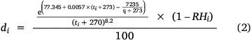
Meteorological variables, including daily measurements of temperature, relative humidity, wind speed and precipitation (Table 1), were obtained from the 11 weather stations within the study area for 2003–2016 (Vietnam Meteorological and Hydrological Administration 2003–2016). We also calculated the MNI (Eqn 1) (Hung 1988; Chau 2012a; Doanh and Quynh 2014; Quy et al. 2017) as a composite variable:
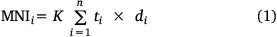
where K = 1 if daily precipitation <5 mm, K = 0 if daily precipitation ≥5 mm, n is the number of consecutive days with daily precipitation <5 mm and di is the air vapour pressure deficit, which is estimated from temperature (ti) and relative humidity (RHi) on day i (Hung 1988) (Eqn 2) as:
Topography
We included three topographic variables: elevation, aspect and slope, generated using forest inventory maps of the Ministry of Agriculture and Rural Development (2016). The elevation layer of those maps (30-m resolution) was derived from the Shuttle Radar Topography Mission dataset (Rabus et al. 2003; Mota et al. 2019; Hung et al. 2021). This was scaled to the 500-m resolution of the MODIS fire data using nearest-neighbour resampling, and then used for calculating the slope and aspect. The aspect (α, in degrees) was converted into a southwestness index (Eqn 3):

Southwestness has values between −1 and 1, indicating the degree to which a slope faces southwest, receiving the greatest potential insolation (Franklin et al. 2000; Khatchikian et al. 2011).
Fuel condition
A remotely sensed vegetation index was used as a proxy for fuel abundance prior to the fire. Among vegetation indices calculated from satellite imagery, the Enhanced Vegetation Index (EVI) was developed to have improved sensitivity in high-biomass regions (Huete et al. 1994; Huete 1997) and has been found to be better correlated with fuel moisture and fuel load than other vegetation indices (Roberts et al. 2006; Myoung et al. 2018). This index has been updated with the two-band EVI (EVI2), which is less susceptible to saturation with biomass (Jiang et al. 2008; Liu et al. 2012; Shang et al. 2014) and has been used as an indicator of fuel condition favouring fire occurrence (Burapapol and Nagasawa 2016).
In this study, we used estimates of EVI2 summarised over the year before fire occurrence from the MODIS Land Cover Dynamics Product, which estimates characteristics of the EVI2 time series for annual and sub-annual growing cycles (MCD12Q2 Collection 6; (Gray et al. 2019)). The range of EVI2 values in a given growing cycle was used as an index of the new production of leaves in the year before fire, and thus the availability of fuel to the fire.
We included the vegetation type where each fire occurred as an additional variable, based on the forest inventory map (Ministry of Agriculture and Rural Development 2016). Forest types were aggregated into four categories (Table 1): closed canopy natural forest including primary and secondary forests (covering 41% of the study area), plantation forest (4%), mixed forest (6%) and bamboo forest (1%).
Human activity
Two variables, population density and distance to nearest road, represented human activity (Table 1). Population density has been correlated positively with potential forest fire occurrence elsewhere (Kwak et al. 2012; Matin et al. 2017; Ma et al. 2020) with human activities now responsible for most fires (de Vasconcelos et al. 2013), while roads may act as fire-breaks, and allow improved access for fire suppression but also a source of additional ignitions (Renard et al. 2012). Gridded population estimates were extracted from the gridded population of the world dataset (Center for International Earth Science Information Network Columbia University 2016), which provided estimated population count and density at approximately 1-km resolution. The road map was extracted from the digital map of the Ministry of Agriculture and Rural Development (2016), from which a raster distance surface was calculated at 500-m resolution.
Statistical approach
We first conducted descriptive analyses of fire occurrence, exploring intra- and inter-annual patterns in the number of fires and their relationships to weather variables. We used logistic regression to test univariate effects of the predictor variables on fire occurrence. In addition, we evaluated if fire activity differed between forest types using chi-squared analyses of the number of fires, and inspection of the fire size distributions to evaluate differences in burned area. Fire size distributions were skewed to small fires and not well described by typical statistical summaries (e.g. mean). Therefore, a power law distribution was fitted to the observed fire sizes by maximum likelihood using R code found in Clauset et al. (2009) and the exponent of the power law distribution was used to compare the distribution of fire size between forest types.
Multivariate Maximum Entropy (Maxent) models were then developed to predict the occurrence of fires and assess the relative importance of the explanatory variables (Table 1). Models were developed using the Maxent software (version 3.4.1, Phillips et al. 2020) and were constructed for each province individually and for all three provinces combined. Maxent (Phillips et al. 2006) is one of the best-performing approaches to predict species distributions in ecological studies (Elith et al. 2006). However, it can be applied to predict the spatial distribution of any phenomenon (e.g. fire: Parisien and Moritz (2009)), or to predict distributions across space and time in response to dynamic environmental conditions (e.g. species: Andrew and Fox (2020); Stoetzel et al. (2020); fire: Chen et al. (2015)). To do so, Maxent fits the relationships between the modelling target, e.g. fire, and the explanatory variables and projects these across geographic space and/or time. Thus, it can be used to evaluate the effect and the importance of each predictor variable on the occurrence of fire.
Maxent requires samples of fire occurrences and background points to predict fire occurrence. Fire occurrences were represented with the ignition points from the Global Fire Atlas dataset. The background points were a random sample of 8630 points (~1.5 × the number of fire points) within the forested portion of the study area, generated within ArcGIS. Background sample sizes by province were 2416, 2244 and 3970 for Dien Bien, Lao Cai and Son La, respectively, and these were aggregated for the combined provinces model. Each background point was assigned a date randomly sampled from the dates of the fires. Values for explanatory variables were assigned to each fire and background point based on their location, year (EVI2) and date (weather variables) of occurrence. Because the weather dataset did not have continuous spatial coverage, points were assigned observations of daily weather variables from the nearest weather station. Correlations between explanatory variables were low for the sample of points (all Spearman r < 0.75); thus, all variables were included in the model (Siljander 2009).
Maxent was run in ‘samples with data’ mode using default settings for the maximum number of iterations (500) and convergence threshold (0.00001), which are used to determine when to stop iteratively fitting the model. Fire points were randomly subsampled, with 75% for training and the remaining 25% for testing. This was repeated 15 times, with the results of the replicates averaged. Model performance was assessed on the test set using the area under the receiver operating characteristic curve (AUC; Fielding and Bell 1997; Elith et al. 2006). AUC ranges from 0 to 1, with values >0.7 generally indicating reasonable performance, and a value of 0.5 indicating performance no better than random (Elith 2000; Elith et al. 2006).
To limit model complexity, the regularisation multiplier was set at 2, 4, 2 and 2 for the models of Dien Bien, Lao Cai, Son La and combined provinces, respectively. These values were selected by comparing model performance when evaluated on the training and test datasets (Supplementary Table S1); a large reduction from training to test AUC suggests that the model is too complex and is overfitted to the training data. Lao Cai, which had the fewest fire occurrences, supported the lowest model complexity. Default feature types (linear, quadratic, product and hinge features) were allowed to the model, to give it flexibility to fit a variety of functional forms of the relationship between the predictor variables and the occurrence of fire. Although the hinge feature type can sometimes result in overfitted models that identify unrealistic relationships, this was effectively mitigated by limiting the complexity of the models with the regularisation multipliers described above.
The importance of each variable to predicting fire occurrence was determined by randomly permuting the values of that variable among the training points (both presence and background) and measuring the resulting decrease in training AUC, normalised to percentages (Phillips 2005). A large reduction indicates that the model depends strongly on that variable. Marginal response curves were also produced to illustrate the relationship between the probability of fire occurrence and each environmental variable when controlling for all other variables.
The spatial predictions of the individual-province Maxent models were mapped for three illustrative days with high (MNI > 2500), moderate (1000 < MNI < 2500) and low (MNI < 1000) fire danger in each province. All spatial variables were aligned to 500-m resolution using nearest-neighbour resampling. Weather data were spatialised by delineating a Thiessen polygon tessellation around the weather stations, assigning each polygon the daily weather measurements from the weather station it contains, and rasterising these values to the analysis resolution. This corresponds to assigning each pixel the observations from the nearest weather station, consistent with how fire and background points were attributed with weather data for model development.
Results
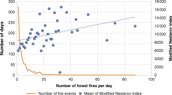
Forest fire occurrence varied markedly over 2003–2016, being highest in 2007 (826 fires), and lowest in 2008 and 2011 (57 and 67 fires, respectively) (Fig. 2a). Almost all fires occurred in the dry season, especially February–April, when MNI was higher and humidity, temperature and rainfall were lower, than in months with fewer fires (Fig. 2b). There were generally few fires per day, but there was a tendency for more fires to burn on days with higher MNI values (linear regression: R2 = 0.15, P < 0.05; Fig. 3).

|
|
Most fires (nearly 5000; 85%) occurred in natural forest, followed by mixed forest. Fire was infrequent in plantation and bamboo forests, with fewer than 100 fires each (Table 2). Fires were more frequent in natural forest than expected given the area occupied by this forest type (Chi-squared P < 0.05), except in Son La where fires were relatively more frequent in mixed forests (Table 2). Fire was much less frequent than expected in plantation forest in all provinces, and in bamboo forests in Dien Bien and Lao Cai (Table 2).

|
Most fires were small (average size 111 ha). Average fire size was lowest for bamboo forest (48 ha) and highest for plantation forest (141 ha); the largest fire occurred in mixed forest (11 900 ha). Fire sizes followed a power law distribution in all forest types (Kolmogorov–Smirnov P > 0.05; Fig. 4). The decline in the cumulative abundance of fires with increasing fire size was steepest for bamboo forest, indicating a greater dominance of small fires (power law exponent γ = 4.02), and most gradual for plantation forest, indicating a greater proportion of larger fires (γ = 1.73) (Fig. 4).

|
Maxent models
Maxent models generally performed well at predicting the occurrence of fire in space and time based on weather, topography, vegetation and anthropogenic variables, with AUC values of 0.7, 0.67, 0.79 and 0.73 for the combined provinces, Dien Bien, Lao Cai, and Son La models, respectively.
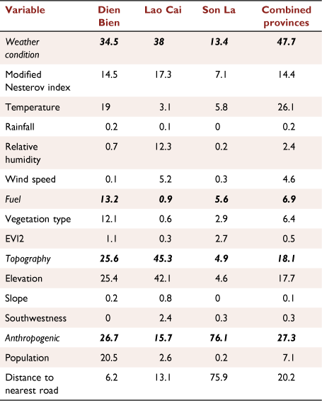
The relative contributions of explanatory variables differed between provinces (Table 3). In Dien Bien, variable importance was reasonably balanced between the top variables; elevation was most important, followed by population, temperature, MNI and vegetation type. In Lao Cai, elevation was again the strongest driver, with 2–3 times greater importance than MNI, distance to road and relative humidity. In Son La, distance to road was the only important driver of fire. The combined provinces model integrated these patterns, finding similar importance of temperature, distance to road, elevation and MNI (Table 3). The remaining variables were never important for predicting fire occurrence (Table 3).
|
Generally, fire was related positively to temperature, MNI, elevation and slope, and negatively to relative humidity and population density in the univariate analyses (Supplementary Table S2). However, Maxent models found plateauing effects of MNI, and peaked effects of elevation (unimodal at mid-elevations) in Dien Bien and combined provinces (Fig. 5). Distance to road had mixed effects on fire occurrence, being negative in Lao Cai, and peaked in Son La and the combined provinces model (Fig. 5).

|
Mapped predictions of forest fire occurrence on selected days with contrasting MNI from the individual-province models reveal that the locations of high fire risk vary temporally (Fig. 6, Supplementary Table S3). Between provinces, the probability of fire was lowest in Lao Cai, especially on the days with medium and high MNI; it was low everywhere on the day with low MNI (Fig. 6c). On the day with high MNI, moderate fire risk was widespread throughout Dien Bien and Son La, with scattered patches of high predicted fire risk in central Lao Cai and Son La (Fig. 6a). On the medium MNI day, areas with moderate fire risk in Dien Bien contracted to the west and were more restricted topographically; in Son La, fire risk was more heterogeneously distributed than on the high MNI day, with prominent patches of especially high fire risk in the centre of the province related to low elevation and high population density; fire risk was evenly low across Lao Cai (Fig. 6b).

|
Discussion
Occurrence of forest fire in northern Vietnam
Most forest fires in northern Vietnam during 2003–2016 occurred in the late dry season (February–March) and the first month of the wet season (April), with 50% of all forest fires in March alone. During this time, temperatures are cool (average temperature 21°C) but low rainfall over the preceding months and low humidity lead to higher daily MNI than at other times of year (Vietnam Meteorological and Hydrological Administration 2003–2016) (Fig. 2b). Although the dry season starts in November, the 2-month lag before most forest fires occur is likely due to fuel condition, with live and dead vegetation still containing high levels of moisture early in the dry season. The abundance of fires in April may also be related to fuel moisture and rainfall, with fuels at their driest before the onset of the new wet season, which varies between years. In any given year, part of April may provide similar fire conditions to March. In our study period, wet season onset (defined as the first day receiving >5 mm rain) was generally in the first week of April, but average daily rainfall on onset dates and throughout April was low (<7 mm).
Fire occurrence also varied among years (Fig. 2a), likely owing to inter-annual climate variability. The greatest fire activity occurred following an El Niño event from September 2006 to January 2007 that resulted in warm, dry conditions in northern Vietnam; the 2007 dry season was warmer, received less rainfall and had lower humidity than the 2003–2016 average. La Niña events impacted northern Vietnam from August 2007 to June 2008 and mid-2010 to May 2011, resulting in colder, wetter conditions (Boening et al. 2012; Gobin et al. 2016) and low fire activity (Fig. 2a). The La Niña dry season in 2008 was colder, received more rainfall, and humidity was higher relative to 2003–2016 averages (Vietnam Meteorological and Hydrological Administration 2003–2016).
Fire frequency was higher than expected in natural forest given the proportion of land area (77.9% of total land area vs 85.7% of total fires) and was lower than expected in plantation (9.9% area vs 1.7% fires) and bamboo forests (2.5% area vs 1.1% fires; Table 2) over the study period (Ministry of Agriculture and Rural Development 2016). Most plantation and bamboo forests occur near villages, and at lower elevations (Sam et al. 2000; Nghia 2006; FAO 2009; Cochard et al. 2017; Cuong et al. 2020). They are often actively protected from fire, with fuel loads reduced through weeding, collection of fuelwood (Nambiar et al. 2015) and regular harvesting in the case of bamboo forest (Nghia 2006; Lobovikov et al. 2007; Trang and Hoi 2009). Additionally, bamboo forests tend to occur in moist locations with low fire risk, such as in valleys and along river banks in lowland moist tropical forests or lower montane forests (e.g. Bambusa, Dendrocalamus, Gigantochloa, Schizostachyum) (Soderstrom and Calderón 1979; Judziewicz et al. 1999; Nghia 2006) or in higher montane systems with high precipitation and humidity (e.g. Chimonobambusa, Indosasa, Arundinaria) (Soderstrom and Calderón 1979; Judziewicz and Clark 2007; Clark et al. 2015; Yakubu et al. 2015).
The fire size distributions give greater understanding of differences in flammability and management between forest types. Higher values of the exponent of the power law distribution correspond to increasing dominance by small fires, with values of 2 used as a threshold between disturbance regimes characterised by diffuse, small events, such as observed here for natural forests, and larger disturbances (Fisher et al. 2008). However, although fire was less frequent in plantation forests, fires were larger and followed a different size distribution (exponent γ < 2) that may be due to different stand attributes and management regimes. The dominant plantation species (e.g. Pinus, Eucalyptus) are highly flammable owing to high content of essential oils (Peña-Fernández and Valenzuela-Palma 2005; Hirschberger 2016; Tumino et al. 2019). Also, these forest types typically have a more open canopy layer than rainforests, leading to lower relative humidity, higher understorey density (Lemenih et al. 2004), and increased surface fuel load and dryness (Jimu and Nyakudya 2018), creating favourable conditions for fire (Pauchard et al. 2008). In all other forest types, fires tended to be small (γ > 2). Fires in bamboo forests were most extremely skewed to small sizes (γ = 4.02), underscoring their low flammability habitat circumstances (Fig. 4).
Drivers of forest fire in northern Vietnam
Identifying the driving factors and understanding their contributions to fire occurrence are essential for forest fire management (Avila-Flores et al. 2010). Our Maxent models found that all groups of variables tested – weather, topography, fuel condition and anthropogenic factors – could have a strong influence on forest fire occurrence in northern Vietnam, but their contribution varied among provinces. MNI, temperature, elevation and distance to road were consistently important in explaining forest fire occurrence, while other variables were only occasionally (population, relative humidity, vegetation type) or never important (daily rainfall, wind speed, EVI2, slope, aspect). This is consistent with other recent studies of tropical and sub-tropical forest fire occurrence, which found meteorological (especially temperature) and human drivers to be most important (Guo et al. 2017; Su et al. 2019; Su et al. 2021). The low individual importance of rainfall and relative humidity in our models is likely because they are already, and more effectively, quantified within the MNI fire danger rating measure, and because they have low variance during the dry season period when nearly all fires occur. However, temperature shows a strong effect separate from its contribution in the MNI, which may be worthy of further exploration in terms of potential future refinements of this FDRS index.
For combined provinces, weather conditions, especially temperature and MNI, were collectively much more important than other factors in explaining fire occurrence. This suggests weather is the most important driver over larger regional scales, consistent with previous work (Schulte et al. 2005; Parisien and Moritz 2009; Viganó et al. 2018), especially Renard et al. (2012) who contrasted regional and local models of fire occurrence in the Western Ghats, India. Weather was also slightly more important in Dien Bien, where drivers of fire occurrence were reasonably balanced between weather, topography and anthropogenic factors. Dien Bien is hotter than the other provinces owing to the stronger presence of hot, dry foehn winds (Vietnam Meteorological and Hydrological Administration 2003–2016; Van 2015). We found fire to be associated with higher MNI and temperatures in both of these models (Fig. 5), as expected from their impacts on fuel moisture (Fried et al. 2008; Sullivan et al. 2012; Chang et al. 2013; Corlett 2016; Holsinger et al. 2016).
In Lao Cai, topography was the dominant driver of fire occurrence, with secondary influences of weather. Lao Cai is the most mountainous of the provinces studied, with mountain ranges exceeding 2000 m including Vietnam’s highest peak (Fansipan, 3143 m), steep slopes, strongly fragmented terrain and a strong gradient between mountain and lowland areas (Lao Cai Provincial Working Group 2002). Elevation was the only important topographic variable in explaining fire occurrence (Table 3), and it was one of the most consistently important variables of any category, although its effect differed between provinces. Most forest fires occurred at 500–1500 m elevation in Dien Bien and the study area as a whole (Fig. 5), where most natural forests with greater continuous extent are located (Averyanov et al. 2003; Phuong et al. 2012; Ministry of Agriculture and Rural Development 2016). In contrast, in Lao Cai, natural forest area and fire occurrence (Fig. 5) both increased with elevation. However, because our background was sampled from forested areas, associations of fire with elevation cannot be explained by the elevation distribution of forest alone. Elevation influences all proximate fire drivers, with effects on vegetation composition, water availability, fuel condition (Castro and Chuvieco 1998) and weather (McCutchan and Fox 1986). Other studies in the tropics have also found increased fire occurrence at higher elevation, most likely due to increased solar radiation and lightning incidence (de Bem et al. 2019; Su et al. 2021).
In Son La, anthropogenic factors were the strongest drivers of fire occurrence, especially distance to road (Table 3). Son La has approximately twice the population of the other provinces (General Statistics office of Vietnam 2019). We found divergent associations of fire with roads between provinces, with fires more likely beyond 5 km from roads in Son La, but within 5 km of roads for Lao Cai. The combined provinces model synthesised these patterns, finding a unimodal response to road distance. Most human activities causing forest fires in Vietnam result from slash and burn farming, use of fire for hunting and trapping wildlife and harvesting honey, and activities related to use of forest products, e.g. cooking and smoking (Hoang 2007; Vien 2014). These activities are often undertaken in natural forests away from towns and villages, but require access, such as by roads. However, roads can be fire breaks and provide access for fire detection and suppression (Renard et al. 2012). Our findings support the occurrence of fires away from populated areas (in Dien Bien) and the diverse mechanisms relating fire to roads. In Son La, which had more fires than Lao Cai and greater importance of roads, fires tended not to occur along roads, suggesting fire suppression in accessible locations. This interpretation is supported by previous studies in Asia that have found fires to be more likely farther from roads (Chang et al. 2013; Sumarga 2017).
Fire danger rating systems
In Vietnam, the Nesterov index, modified for local conditions, has been used since the 1980s to indicate forest fire danger. MNI is based on weather conditions only, and does not include other factors impacting fire occurrence and spread such as fuel condition, topography and ignition sources (Chau 2012b; Doanh and Bao 2014; Vien 2014; Hoan 2018). Use of the MNI is consistent with most widely used FDRSs elsewhere, such as the Canadian Forest FDRS (Van Wagner 1987; Taylor and Alexander 2006), the National FDRS of the USA (Deeming et al. 1977) and the Forest Fire Danger Index of Australia (Noble et al. 1980). However, although these systems only explicitly include weather conditions, the effects of additional factors such as fuel condition and slope are incorporated into fire behaviour prediction and fire management planning.
Our findings suggest that the MNI is a useful measure for predicting fire danger conditions for forest areas in northern Vietnam but that incorporation of other variables, including anthropogenic, fuel and topographic factors provides a better overall model for predicting forest fire occurrence (Supplementary Fig. S1 shows jackknife measures of variable importance comparing the performance of full models with those using e.g. only MNI). Therefore, this study recommends that important factors beyond weather should be considered to improve the prediction of, response to and education about forest fire occurrence in Vietnam. Topographic and anthropogenic variables were also important and can be obtained easily from digital elevation maps or proxied by remotely sensed data to augment the current FDRS. Fuel conditions are also known to be important, but the fuel variables used in this study showed low importance in all models, possibly because they are indirectly related to the fuel characteristics important to fire occurrence and spread and are not measured at the spatial or temporal scales most relevant to their effects on fire, or because fuel load is not a critical driver of fire in these forests (with all forested areas likely to have sufficient fuel to carry a fire if other conditions are conducive to fire occurrence).
Conclusion
This study provides an improved understanding of patterns of wildfire occurrence in the forests of northern Vietnam through a range of descriptive and quantitative analyses. Generally, the most fire-prone period was the mid-dry season to onset of the wet season, corresponding to February–April. Forest fires occurred mostly in natural forest while they rarely occurred, but tended to be larger, in plantation forests.
Maxent models showed good performance in explaining fire occurrence and identifying its drivers, including weather conditions, fuel, anthropogenic and topographic variables, but found the relative importance of these drivers depended on extent (local vs regional) and the position of each province on these gradients. The findings of these models, including the mapped results, can assist managers and decision-makers to build forest fire management plans adjusted to each province’s fire conditions. For instance, forest fire managers and authorities can prioritise areas close to roads at high elevation in Lao Cai, mid-elevation areas with low population density in Dien Bien, and forests distant from roads in Son La for efficient prevention measures to reduce forest fire risk on days with high and moderate MNI in the late dry season to early wet season. Results from our study show that while MNI is a significant predictor of high fire danger days, spatial (Maxent) model analyses provide additional understanding of where fire danger is highest on such high-MNI days. We recommend that this improved understanding of fire occurrence be used to guide education about fire and planning for fire mitigation and suppression in Vietnam.
This study has developed statistical models of fire occurrence that may support improved management in tropical forests in Vietnam and other countries with comparable climate and vegetation. However, further research is needed to assess other aspects of fire regimes such as fire size, severity and impacts, and social factors influencing ignitions, as well as the effectiveness of fire prevention strategies to support forest fire management in Vietnam.
Data availability
The data that support this study will be shared on reasonable request to the corresponding author.
Conflicts of interest
The authors declare they have no conflicts of interest.
Declaration of funding
This research was funded by a PhD scholarship to TTP from Murdoch University and the Vietnam International Education Development program (VIED), and field logistical support from Murdoch University.
Supplementary material
Supplementary material is available online.
Acknowledgements
The authors thank Associate Professor Ho Dang Phuc, Institute of Mathematics, Vietnam Academy of Science and Technology, Vietnam, for assistance with preliminary data analysis. We thank Dr. Joseph B Fontaine for his contribution to the original research design.
References
Adámek M, Jankovská Z, Hadincová V, Kula E, Wild J (2018) Drivers of forest fire occurrence in the cultural landscape of Central Europe. Landscape Ecology 33, 2031–2045.| Drivers of forest fire occurrence in the cultural landscape of Central Europe.Crossref | GoogleScholarGoogle Scholar |
Alvarado ST, Fornazari T, Cóstola A, Morellato LPC, Silva TSF (2017) Drivers of fire occurrence in a mountainous Brazilian cerrado savanna: tracking long-term fire regimes using remote sensing. Ecological Indicators 78, 270–281.
| Drivers of fire occurrence in a mountainous Brazilian cerrado savanna: tracking long-term fire regimes using remote sensing.Crossref | GoogleScholarGoogle Scholar |
Andela N, Morton DC, Giglio L, Paugam R, Chen Y, Hantson S, van Der Werf GR, Randerson JT (2019) The Global Fire Atlas of individual fire size, duration, speed and direction. Earth System Science Data 11, 529–552.
| The Global Fire Atlas of individual fire size, duration, speed and direction.Crossref | GoogleScholarGoogle Scholar |
Andrew ME, Fox E (2020) Modelling species distributions in dynamic landscapes: the importance of the temporal dimension. Journal of Biogeography 47, 1510–1529.
| Modelling species distributions in dynamic landscapes: the importance of the temporal dimension.Crossref | GoogleScholarGoogle Scholar |
Averyanov LV, Loc PK, Hiep NT, Harder DK (2003) Phytogeographic review of Vietnam and adjacent areas of Eastern Indochina. Komarovia 3, 1–83.
Avila-Flores D, Pompa-Garcia M, Antonio-Nemiga X, Rodriguez-Trejo DA, Vargas-Perez E, Santillan-Perez J (2010) Driving factors for forest fire occurrence in Durango State of Mexico: a geospatial perspective. Chinese Geographical Science 20, 491–497.
| Driving factors for forest fire occurrence in Durango State of Mexico: a geospatial perspective.Crossref | GoogleScholarGoogle Scholar |
Bennett M, Fitzgerald SA, Parker B, Main ML, Perleberg A, Schnepf C, Mahoney RL (2010) ‘Reducing fire risk on your forest property.’ (A Pacific Northwest Extension Publication: Oregon State University & University of Idaho & Washington State University).
Bessie WC, Johnson EA (1995) The relative importance of fuels and weather on fire behavior in subalpine forests. Ecology 76, 747–762.
| The relative importance of fuels and weather on fire behavior in subalpine forests.Crossref | GoogleScholarGoogle Scholar |
Birch DS, Morgan P, Kolden CA, Abatzoglou JT, Dillon GK, Hudak AT, Smith AMS (2015) Vegetation, topography and daily weather influenced burn severity in central Idaho and western Montana forests. Ecosphere 6, 1–23.
| Vegetation, topography and daily weather influenced burn severity in central Idaho and western Montana forests.Crossref | GoogleScholarGoogle Scholar |
Boening C, Willis JK, Landerer FW, Nerem RS, Fasullo J (2012) The 2011 La Niña: So strong, the oceans fell. Geophysical Research Letters 39, 1–5.
| The 2011 La Niña: So strong, the oceans fell.Crossref | GoogleScholarGoogle Scholar |
Bowman D, Balch J, Artaxo P, Bond WJ, Cochrane MA, D’antonio CM, DeFries R, Johnston FH, Keeley JE, Krawchuk MA (2011) The human dimension of fire regimes on Earth. Journal of Biogeography 38, 2223–2236.
| The human dimension of fire regimes on Earth.Crossref | GoogleScholarGoogle Scholar | 22279247PubMed |
Bradstock RA (2010) A biogeographic model of fire regimes in Australia: current and future implications. Global Ecology and Biogeography 19, 145–158.
| A biogeographic model of fire regimes in Australia: current and future implications.Crossref | GoogleScholarGoogle Scholar |
Burapapol K, Nagasawa R (2016) Mapping wildfire fuel load distribution using Landsat 8 Operational Land Imager (OLI) data in Sri Lanna National Park, northern Thailand. Journal of the Japanese Agricultural Systems Society 32, 133–145.
| Mapping wildfire fuel load distribution using Landsat 8 Operational Land Imager (OLI) data in Sri Lanna National Park, northern Thailand.Crossref | GoogleScholarGoogle Scholar |
Camp A, Oliver C, Hessburg P, Everett R (1997) Predicting late-successional fire refugia pre-dating European settlement in the Wenatchee Mountains. Forest Ecology and Management 95, 63–77.
| Predicting late-successional fire refugia pre-dating European settlement in the Wenatchee Mountains.Crossref | GoogleScholarGoogle Scholar |
Castro R, Chuvieco E (1998) Modeling forest fire danger from geographic information systems. Geocarto International 13, 15–23.
| Modeling forest fire danger from geographic information systems.Crossref | GoogleScholarGoogle Scholar |
Center for International Earth Science Information Network Columbia University (2016) ‘Gridded Population of the World, Version 4 (GPWv4): Population Density Adjusted to Match 2015 Revision UN WPP Country Totals.’ (NASA Socioeconomic Data and Applications Center (SEDAC))
Chang Y, Zhu Z, Bu R, Chen H, Feng Y, Li Y, Hu Y, Wang Z (2013) Predicting fire occurrence patterns with logistic regression in Heilongjiang Province, China. Landscape Ecology 28, 1989–2004.
| Predicting fire occurrence patterns with logistic regression in Heilongjiang Province, China.Crossref | GoogleScholarGoogle Scholar |
Chau BM (2012a) ‘Forest fire management.’ (Agriculture Publisher: Hanoi, Vietnam)
Chau BM (2012b) Selection of fire-resistant plant species in the northern mountainous region of Vietnam. Journal of Agriculture and Rural Development 11, 137–144.
Chen F, Du Y, Niu S, Zhao J (2015) Modeling forest lightning fire occurrence in the Daxinganling Mountains of Northeastern China with MAXENT. Forests 6, 1422–1438.
| Modeling forest lightning fire occurrence in the Daxinganling Mountains of Northeastern China with MAXENT.Crossref | GoogleScholarGoogle Scholar |
Clark LG, Londoño X, Ruiz-Sanchez E (2015) Bamboo taxonomy and habitat. In ‘Bamboo’. (Eds W Liese, M Köhl) pp. 1–30. (Springer: Cham)
Clarke PJ, Lawes MJ, Midgley JJ, Lamont BB, Ojeda F, Burrows GE, Enright NJ, Knox KJE (2013) Tansley review: resprouting as a key functional trait: how buds, protection and resources drive persistence after fire. New Phytologist 197, 19–35.
| Tansley review: resprouting as a key functional trait: how buds, protection and resources drive persistence after fire.Crossref | GoogleScholarGoogle Scholar |
Clauset A, Shalizi CR, Newman MEJ (2009) Power-law distributions in empirical data. SIAM Review 51, 661–703.
| Power-law distributions in empirical data.Crossref | GoogleScholarGoogle Scholar |
Cochard R, Ngo DT, Waeber PO, Kull CA (2017) Extent and causes of forest cover changes in Vietnam’s provinces 1993–2013: a review and analysis of official data. Environmental Reviews 25, 199–217.
| Extent and causes of forest cover changes in Vietnam’s provinces 1993–2013: a review and analysis of official data.Crossref | GoogleScholarGoogle Scholar |
Cochrane MA (2001) Synergistic interactions between habitat fragmentation and fire in evergreen tropical forests. Conservation Biology 15, 1515–1521.
| Synergistic interactions between habitat fragmentation and fire in evergreen tropical forests.Crossref | GoogleScholarGoogle Scholar |
Cochrane MA (2002) ‘Spreading like wildfire: Tropical forest fires in Latin America and the Caribbean.’ (United Nations Environment Programme (UNEP))
Cochrane MA (2003) Fire science for rainforests. Nature 421, 913–919.
| Fire science for rainforests.Crossref | GoogleScholarGoogle Scholar | 12606992PubMed |
Corlett RT (2016) The impacts of droughts in tropical forests. Trends in Plant Science 21, 584–593.
| The impacts of droughts in tropical forests.Crossref | GoogleScholarGoogle Scholar | 26994658PubMed |
Cruz MG, Alexander ME (2017) Modelling the rate of fire spread and uncertainty associated with the onset and propagation of crown fires in conifer forest stands. International Journal of Wildland Fire 26, 413–426.
| Modelling the rate of fire spread and uncertainty associated with the onset and propagation of crown fires in conifer forest stands.Crossref | GoogleScholarGoogle Scholar |
Cuong T, Chinh TTQ, Zhang Y, Xie Y (2020) Economic performance of forest plantations in Vietnam: Eucalyptus, Acacia mangium, and Manglietia conifera. Forests 11, 284.
| Economic performance of forest plantations in Vietnam: Eucalyptus, Acacia mangium, and Manglietia conifera.Crossref | GoogleScholarGoogle Scholar |
de Bem PP, de Carvalho Júnior OA, Matricardi EAT, Guimarães RF, Gomes RAT (2019) Predicting wildfire vulnerability using logistic regression and artificial neural networks: a case study in Brazil’s Federal District. International Journal of Wildland Fire 28, 35–45.
| Predicting wildfire vulnerability using logistic regression and artificial neural networks: a case study in Brazil’s Federal District.Crossref | GoogleScholarGoogle Scholar |
de Groot WJ, Field RD, Brady MA, Roswintiarti O, Mohamad M (2007) Development of the Indonesian and Malaysian fire danger rating systems. Mitigation and Adaptation Strategies for Global Change 12, 165.
| Development of the Indonesian and Malaysian fire danger rating systems.Crossref | GoogleScholarGoogle Scholar |
de Vasconcelos SS, Fearnside P, de Alencastro Graça P, Nogueira E, de Oliveira L, Figueiredo E (2013) Forest fires in southwestern Brazilian Amazonia: Estimates of area and potential carbon emissions. Forest Ecology and Management 291, 199–208.
| Forest fires in southwestern Brazilian Amazonia: Estimates of area and potential carbon emissions.Crossref | GoogleScholarGoogle Scholar |
Deeming JE, Burgan RE, Cohen JD (1977) ‘The national fire-danger rating system, 1978.’ (Intermountain Forest and Range Experiment Station, Forest Service, US Department of Agriculture)
Doanh LS, Bao TQ (2014) Impact of climate change on forest fire risk in Vietnam. Journal of Agriculture and Rural Development 7, 113–118.
Doanh LS, Quynh VV (2014) Forecasting method of forest fire risk by climate conditions in Vietnam. Journal of Forestry Science and Technology 1, 3–10.
Elhag M, Boteva S (2021) The Canadian versus the National Forest Fire Danger Rating Systems tested in Mediterranean forests fire Crete, Greece. Environment, Development and Sustainability 23, 4973–4983.
| The Canadian versus the National Forest Fire Danger Rating Systems tested in Mediterranean forests fire Crete, Greece.Crossref | GoogleScholarGoogle Scholar |
Elith J (2000) Quantitative methods for modeling species habitat: comparative performance and an application to Australian plants. In ‘Quantitative methods for conservation biology’. (Eds S Ferson, M Burgman) pp. 39–58. (Springer: New York, NY)
Elith J, Graham CH, Anderson RP, Dudík M, Ferrier S, Guisan A, Hijmans RJ, Huettmann F, Leathwick JR, Lehmann A, Li J, Lohmann LG, Loiselle BA, Manion G, Moritz C, Nakamura M, Nakazawa Y, Overton JMM, Peterson AT, Phillips SJ, Richardson K, Scachetti‐Pereira R, Schapire RE, Soberón J, Williams S, Wisz MS, Zimmermann NE (2006) Novel methods improve prediction of species’ distributions from occurrence data. Ecography 29, 129–151.
| Novel methods improve prediction of species’ distributions from occurrence data.Crossref | GoogleScholarGoogle Scholar |
Enright NJ (2011) Fire and ecosystem function. In ‘The SAGE handbook of biogeography’. (Eds A Millington, M Blumler, U Schickhoff) p. 212. (Sage: Singapore)
Enright NJ, Fontaine JB, Lamont BB, Miller BP, Westcott VC (2014) Resistance and resilience to changing climate and fire regime depend on plant functional traits. Journal of Ecology 102, 1572–1581.
| Resistance and resilience to changing climate and fire regime depend on plant functional traits.Crossref | GoogleScholarGoogle Scholar |
Fang L, Yang J, Zu J, Li G, Zhang J (2015) Quantifying influences and relative importance of fire weather, topography, and vegetation on fire size and fire severity in a Chinese boreal forest landscape. Forest Ecology and Management 356, 2–12.
FAO (2009) ‘ Vietnam Forestry Outlook Study.’ (Food and Agricultural Organization of The United Nations Regional office for Asia and the Pacific: Bangkok)
Fielding AH, Bell JF (1997) A review of methods for the assessment of prediction errors in conservation presence/absence models. Environmental Conservation 24, 38–49.
Fisher JI, Hurtt GC, Thomas RQ, Chambers JQ (2008) Clustered disturbances lead to bias in large‐scale estimates based on forest sample plots. Ecology Letters 11, 554–563.
| Clustered disturbances lead to bias in large‐scale estimates based on forest sample plots.Crossref | GoogleScholarGoogle Scholar | 18373680PubMed |
Flannigan M, Cantin AS, de Groot WJ, Wotton M, Newbery A, Gowman LM (2013) Global wildland fire season severity in the 21st century. Forest Ecology and Management 294, 54–61.
| Global wildland fire season severity in the 21st century.Crossref | GoogleScholarGoogle Scholar |
Forest Protection Department (2020) Yearly report on forest fire and destruction (2017–2020) in northern Vietnam. Unpublished report. Minister of Agriculture and Rural Development. (Hanoi, Vietnam)
Franklin J, McCullough P, Gray C (2000) Terrain variables used for predictive mapping of vegetation communities in southern California. In ‘Terrain analysis: Principles and applications’. (Eds JP Wilson, JC Gallant) pp. 331–3553. (Willey: New York, NY)
Fried JS, Gilless J, Riley WJ, Moody TJ, De Blas CS, Hayhoe K, Moritz M, Stephens S, Torn M (2008) Predicting the effect of climate change on wildfire behavior and initial attack success. Climatic Change 87, 251–264.
| Predicting the effect of climate change on wildfire behavior and initial attack success.Crossref | GoogleScholarGoogle Scholar |
General Statistics Office of Vietnam (2011). Statistical yearbook of Vietnam. Available at https://www.gso.gov.vn/wp-content/uploads/2021/07/Sach-NGTK-2020Ban-quyen.pdf [Verified 24 January 2022]
General Statistics Office of Vietnam (2019) Completed results of the 2019 Vietnam population and housing census. Available at https:// www.gso.gov.vn/en/data-and-statistics/2020/11/completed-results- of-the-2019-viet-nam-population-and-housing-census/ [Verified 5 February 2021]
Gerwing JJ (2002) Degradation of forests through logging and fire in the eastern Brazilian Amazon. Forest Ecology and Management 157, 131–141.
| Degradation of forests through logging and fire in the eastern Brazilian Amazon.Crossref | GoogleScholarGoogle Scholar |
Gobin A, Nguyen HT, Pham VQ, Pham HTT (2016) Heavy rainfall patterns in Vietnam and their relation with ENSO cycles. International Journal of Climatology 36, 1686–1699.
| Heavy rainfall patterns in Vietnam and their relation with ENSO cycles.Crossref | GoogleScholarGoogle Scholar |
Goldammer JG (2007) History of equatorial vegetation fires and fire research in southeast Asia before the 1997–98 episode: A reconstruction of creeping environmental changes. Mitigation and Adaptation Strategies for Global Change 12, 13–32.
| History of equatorial vegetation fires and fire research in southeast Asia before the 1997–98 episode: A reconstruction of creeping environmental changes.Crossref | GoogleScholarGoogle Scholar |
Grala K, Grala RK, Hussain A, Cooke IIIWH, Varner JM (2017) Impact of human factors on wildfire occurrence in Mississippi, United States. Forest Policy and Economics 81, 38–47.
| Impact of human factors on wildfire occurrence in Mississippi, United States.Crossref | GoogleScholarGoogle Scholar |
Gray JM, Melaas EK, Sulla-Menashe D, Moon M, Friedl MA (2019) Global Land Surface Phenology from MODIS: Collection 6 Products. Available at https://lpdaac.usgs.gov/products/mcd12q2v006/ [Verified 15 February 2021]
Guo F, Su Z, Tigabu M, Yang X, Lin F, Liang H, Wang G (2017) Spatial modelling of fire drivers in urban-forest ecosystems in China. Forests 8, 180.
| Spatial modelling of fire drivers in urban-forest ecosystems in China.Crossref | GoogleScholarGoogle Scholar |
Harvey BJ, Donato DC, Turner MG (2016) Drivers and trends in landscape patterns of stand-replacing fire in forests of the US Northern Rocky Mountains (1984–2010). Landscape Ecology 31, 2367–2383.
| Drivers and trends in landscape patterns of stand-replacing fire in forests of the US Northern Rocky Mountains (1984–2010).Crossref | GoogleScholarGoogle Scholar |
Herawati H, Santoso H (2011) Tropical forest susceptibility to and risk of fire under changing climate: A review of fire nature, policy and institutions in Indonesia. Forest Policy and Economics 13, 227–233.
| Tropical forest susceptibility to and risk of fire under changing climate: A review of fire nature, policy and institutions in Indonesia.Crossref | GoogleScholarGoogle Scholar |
Hirschberger P (2016) ‘Forests ablaze: causes and effects of global forest fires.’ (WWF: Berlin, Germany). Available at https://wwf.de/fileadmin/fm-wwf/Publikationen-PDF/WWF-Study-Forests-Ablaze.pdf [Verified 8 September 2021]
Hoan L (2018) Effective application of Geospatial technology (RS, GIS, and GPS) to detect forest fire in Vietnam. Available at http://elib.vnuf.edu.vn/handle/123456789/6167 [Verified 15 April 2019]
Hoang MH (2007) Status of Forest Fire Management and Control in Vietnam. GEOSS Symposium on Integrated Observation for Sustainable Development in the Asia-Pacific Region’, 11-12 January 2007, Tokyo, Japan. Group on Earth Observations (GEO). Available at http://www.earthobservations.org [Verified 24 January 2022]
Holsinger L, Parks SA, Miller C (2016) Weather, fuels, and topography impede wildland fire spread in western US landscapes. Forest Ecology and Management 380, 59–69.
| Weather, fuels, and topography impede wildland fire spread in western US landscapes.Crossref | GoogleScholarGoogle Scholar |
Huete A, Justice C, Liu H (1994) Development of vegetation and soil indices for MODIS-EOS. Remote Sensing of Environment 49, 224–234.
| Development of vegetation and soil indices for MODIS-EOS.Crossref | GoogleScholarGoogle Scholar |
Huete AR, Liu HQ, Batchily KV, Van Leeuwen WJDA (1997) A comparison of vegetation indices over a global set of TM images for EOS-MODIS. Remote Sensing of Environment 59, 440–451.
| A comparison of vegetation indices over a global set of TM images for EOS-MODIS.Crossref | GoogleScholarGoogle Scholar |
Hung PN (1988) Establishing of early fire warning system in pine forests (Pinus merkusii) in Quang Ninh province. Unpublished doctoral dissertation. Institute of Forestry, Hanoi, Vietnam.
Hung LV, Anh HD, Trung TC, Quoc NP, Duc HN, Mahdis A, Phuong TNT, Nhu HV, Thong HV, Tien BD (2021) A new approach of deep neural computing for spatial prediction of wildfire danger at tropical climate areas. Ecological Informatics 63, 101300.
| A new approach of deep neural computing for spatial prediction of wildfire danger at tropical climate areas.Crossref | GoogleScholarGoogle Scholar |
Jiang Z, Huete AR, Didan K, Miura T (2008) Development of a two-band enhanced vegetation index without a blue band. Remote Sensing of Environment 112, 3833–3845.
| Development of a two-band enhanced vegetation index without a blue band.Crossref | GoogleScholarGoogle Scholar |
Jimu L, Nyakudya IW (2018) Fires in exotic forest plantations of Zimbabwe: Causes and management strategies. World Development Perspectives 9, 56–58.
| Fires in exotic forest plantations of Zimbabwe: Causes and management strategies.Crossref | GoogleScholarGoogle Scholar |
Juárez-Orozco SM, Siebe C, Fernández y, Fernández D (2017) Causes and effects of forest fires in tropical rainforests: A bibliometric approach. Tropical Conservation Science 10, 1940082917737207.
| Causes and effects of forest fires in tropical rainforests: A bibliometric approach.Crossref | GoogleScholarGoogle Scholar |
Judziewicz EJ, Clark LG (2007) Classification and biogeography of new world grasses: Anomochlooideae, Pharoideae, Ehrhartoideae, and Bambusoideae. Aliso: A Journal of Systematic and Evolutionary Botany 23, 303–314.
| Classification and biogeography of new world grasses: Anomochlooideae, Pharoideae, Ehrhartoideae, and Bambusoideae.Crossref | GoogleScholarGoogle Scholar |
Judziewicz EJ, Clark LG, Londoño X, Stern MJ (1999) ‘American bamboos.’ (Smithsonian Institution Press: Washington, DC)
Kauffman JB, Uhl C (1990) Interactions of anthropogenic activities, fire, and rain forests in the Amazon Basin. In ‘Fire in the tropical biota’. (Ed JG Goldammer) pp. 117–134. (Springer: Berlin)
Khatchikian C, Sangermano F, Kendell D, Livdahl T (2011) Evaluation of species distribution model algorithms for fine‐scale container‐breeding mosquito risk prediction. Medical and Veterinary Entomology 25, 268–275.
| Evaluation of species distribution model algorithms for fine‐scale container‐breeding mosquito risk prediction.Crossref | GoogleScholarGoogle Scholar | 21198711PubMed |
Knorr W, Kaminski T, Arneth A, Weber U (2014) Impact of human population density on fire frequency at the global scale. Biogeosciences 11, 1085–1102.
| Impact of human population density on fire frequency at the global scale.Crossref | GoogleScholarGoogle Scholar |
Kwak H, Lee WK, Saborowski J, Lee SY, Won MS, Koo KS, Lee MB, Kim SN (2012) Estimating the spatial pattern of human-caused forest fires using a generalized linear mixed model with spatial autocorrelation in South Korea. International Journal of Geographical Information Science 26, 1589–1602.
| Estimating the spatial pattern of human-caused forest fires using a generalized linear mixed model with spatial autocorrelation in South Korea.Crossref | GoogleScholarGoogle Scholar |
Lamont BB, Le Maitre DC, Cowling RM, Enright NJ (1991) Canopy seed storage in woody plants. Botanical Review 57, 277–317.
Lao Cai Provincial Working Group (2002) Assessment of the special-use forest system and its management in Lao Cai Province. Technical Report No. 5 in Strengthening Protected Area Management in Vietnam - SPAM Project. (Hanoi, Vietnam) Available at https://vanban.chinhphu.vn/default.aspx?pageid=27160&docid=89016 [Verified 24 January 2022]
Le TH, Nguyen TNT, Lasko K, Ilavajhala S, Vadrevu KP, Justice C (2014) Vegetation fires and air pollution in Vietnam. Environmental Pollution 195, 267–275.
| Vegetation fires and air pollution in Vietnam.Crossref | GoogleScholarGoogle Scholar | 25108840PubMed |
Lee HJ, Choi Y, Lee SW (2018) Complex relationships of the effects of topographic characteristics and susceptible tree cover on burn severity. Sustainability 10, 295.
| Complex relationships of the effects of topographic characteristics and susceptible tree cover on burn severity.Crossref | GoogleScholarGoogle Scholar |
Lemenih M, Gidyelew T, Teketay D (2004) Effects of canopy cover and understory environment of tree plantations on richness, density and size of colonizing woody species in southern Ethiopia. Forest Ecology and Management 194, 1–10.
| Effects of canopy cover and understory environment of tree plantations on richness, density and size of colonizing woody species in southern Ethiopia.Crossref | GoogleScholarGoogle Scholar |
Lewis S, Edwards D, Galbraith D (2015) Increasing human dominance of tropical forests. Science 349, 827–832.
| Increasing human dominance of tropical forests.Crossref | GoogleScholarGoogle Scholar | 26293955PubMed |
Liu J, Pattey E, Jégo G (2012) Assessment of vegetation indices for regional crop green LAI estimation from Landsat images over multiple growing seasons. Remote Sensing of Environment 123, 347–358.
| Assessment of vegetation indices for regional crop green LAI estimation from Landsat images over multiple growing seasons.Crossref | GoogleScholarGoogle Scholar |
Lobovikov M, Paudel S, Ball L, Piazza M, Guardia M, Ren H, Russo L, Wu J (2007) ‘World bamboo resources: A thematic study prepared in the framework of the global forest resources assessment 2005.’ (Food and Agriculture Organization of the United Nations)
Luke RH, McArthur AG (1978) ‘Bushfires in Australia.’ (Australian Government Publishing Service: Canberra, ACT)
Ma W, Feng Z, Cheng Z, Chen S, Wang F (2020) Identifying forest fire driving factors and related impacts in China using random forest algorithm. Forests 11, 507.
| Identifying forest fire driving factors and related impacts in China using random forest algorithm.Crossref | GoogleScholarGoogle Scholar |
Martínez J, Vega-Garcia C, Chuvieco E (2009) Human-caused wildfire risk rating for prevention planning in Spain. Journal of Environmental Management 90, 1241–1252.
| Human-caused wildfire risk rating for prevention planning in Spain.Crossref | GoogleScholarGoogle Scholar | 18723267PubMed |
Matin MA, Chitale VS, Murthy MSR, Uddin K, Bajracharya B, Pradhan S (2017) Understanding forest fire patterns and risk in Nepal using remote sensing, geographic information system and historical fire data. International Journal of Wildland Fire 26, 276–286.
| Understanding forest fire patterns and risk in Nepal using remote sensing, geographic information system and historical fire data.Crossref | GoogleScholarGoogle Scholar |
McCutchan MH, Fox DG (1986) Effect of elevation and aspect on wind, temperature and humidity. Journal of Climate and Applied Meteorology 25, 1996–2013.
| Effect of elevation and aspect on wind, temperature and humidity.Crossref | GoogleScholarGoogle Scholar |
McWethy DB, Pauchard A, García RA, Holz A, González ME, Veblen TT, Stahl J, Currey B (2018) Landscape drivers of recent fire activity (2001-2017) in south-central Chile. PloS One 13, e0201195.
| Landscape drivers of recent fire activity (2001-2017) in south-central Chile.Crossref | GoogleScholarGoogle Scholar | 30133449PubMed |
Ministry of Agriculture and Rural Development (2009) Circular No.34/2009/TT-BNNPTNT dated 10 June, 2009 on criteria for forest identification and classification. Available at http://vanban.chinhphu.vn/default.aspx?pageid=27160&docid=89016 [Verified 24 January 2022]
Ministry of Agriculture and Rural Development (2016) National forest inventory map. Unpublished document. Ministry of Agriculture and Development. (Hanoi, Vietnam)
Moritz MA, Morais ME, Summerell LA, Carlson JM, Doyle J (2005) Wildfires, complexity, and highly optimized tolerance. Proceedings of the National Academy of Sciences 102, 17912–17917.
| Wildfires, complexity, and highly optimized tolerance.Crossref | GoogleScholarGoogle Scholar |
Mota P, da Rocha S, de Castro N, Marcatti G, de Jesus França L, Schettini B, Villanova P, dos Santos H, dos Santos A (2019) Forest fire hazard zoning in Mato Grosso State, Brazil. Land Use Policy 88, 104206.
| Forest fire hazard zoning in Mato Grosso State, Brazil.Crossref | GoogleScholarGoogle Scholar |
Myoung B, Kim SH, Nghiem SV, Jia S, Whitney K, Kafatos MC (2018) Estimating live fuel moisture from MODIS satellite data for wildfire danger assessment in Southern California USA. Remote Sensing 10, 87.
| Estimating live fuel moisture from MODIS satellite data for wildfire danger assessment in Southern California USA.Crossref | GoogleScholarGoogle Scholar |
Nambiar EKS, Harwood CE, Kien ND (2015) Acacia plantations in Vietnam: research and knowledge application to secure a sustainable future. Southern Forests: A Journal of Forest Science 77, 1–10.
Nghia NH (2006) ‘Bamboos of Vietnam.’ (Agricultural Publishing: Hanoi, Vietnam)
Noble IR, Gill AM, Bary GAV (1980) McArthur’s fire‐danger meters expressed as equations. Australian Journal of Ecology 5, 201–203.
| McArthur’s fire‐danger meters expressed as equations.Crossref | GoogleScholarGoogle Scholar |
Nyman P, Metzen D, Noske PJ, Lane PNJ, Sheridan GJ (2015) Quantifying the effects of topographic aspect on water content and temperature in fine surface fuel. International Journal of Wildland Fire 24, 1129–1142.
| Quantifying the effects of topographic aspect on water content and temperature in fine surface fuel.Crossref | GoogleScholarGoogle Scholar |
Parisien M, Moritz MA (2009) Environmental controls on the distribution of wildfire at multiple spatial scales. Ecological Monographs 79, 127–154.
| Environmental controls on the distribution of wildfire at multiple spatial scales.Crossref | GoogleScholarGoogle Scholar |
Parks SA, Holsinger LM, Panunto MH, Jolly WM, Dobrowski SZ, Dillon GK (2018) High-severity fire: Evaluating its key drivers and mapping its probability across western US forests. Environmental Research Letters 13, 044037.
Pauchard A, García RA, Pena E, González C, Cavieres LA, Bustamante RO (2008) Positive feedbacks between plant invasions and fire regimes: Teline monspessulana (L.) K. Koch (Fabaceae) in central Chile. Biological Invasions 10, 547–553.
| Positive feedbacks between plant invasions and fire regimes: Teline monspessulana (L.) K. Koch (Fabaceae) in central Chile.Crossref | GoogleScholarGoogle Scholar |
Pausas JG, Keeley JE (2009) A burning story: the role of fire in the history of life. Bioscience 59, 593–601.
| A burning story: the role of fire in the history of life.Crossref | GoogleScholarGoogle Scholar |
Peña-Fernández E, Valenzuela-Palma L (2005) The Increase in Forest Fires in Natural Woodland and Forestry Plantations in Chile. In ‘Proceedings of the Second International Symposium on Fire Economics, Planning, and Policy: A Global View’. (Ed GC Armando) pp. 549–565. (PSW-GTR-208. USDA Forest Service, Pacific Southwest Research Station: Albany, CA). Available at https://www.fs.fed.us/psw/publications/documents/psw_gtr208en/psw_gtr208en_549-566_pena-fernandez.pdf [Verified 8 September 2021]
Phillips SJ (2005) A brief tutorial on Maxent. AT&T Research 190, 231–259.
Phillips SJ, Anderson RP, Schapire RE (2006) Maximum entropy modeling of species geographic distributions. Ecological Modelling 190, 231–259.
| Maximum entropy modeling of species geographic distributions.Crossref | GoogleScholarGoogle Scholar |
Phillips SJ, Miroslav D, Robert ES (2020) Maxent software for modeling species niches and distributions (Version 3.4.1). Available at http://biodiversityinformatics.amnh.org/open_source/maxent/ [Accessed 7 July, 2020]
Phuong VT, Anh HV, Lung NN, Sam DD, Ky ND, Lien TV (2012) ‘Forest ecological stratification in Vietnam.’ (UN-REDD Programme Vietnam)
Quy NV, Khoa TD, Phu NV, Hanh NT (2017) The effect of climatic factors on the risks of forest fire in Vinh Cuu - Dong Nai. Journal of Forestry Science and Technology 6, 117–123.
Rabus B, Eineder M, Roth A, Bamler R (2003) The shuttle radar topography mission—a new class of digital elevation models acquired by spaceborne radar. ISPRS Journal of Photogrammetry and Remote Sensing 57, 241–262.
| The shuttle radar topography mission—a new class of digital elevation models acquired by spaceborne radar.Crossref | GoogleScholarGoogle Scholar |
Renard Q, Pélissier R, Ramesh BR, Kodandapani N (2012) Environmental susceptibility model for predicting forest fire occurrence in the Western Ghats of India. International Journal of Wildland Fire 21, 368–379.
| Environmental susceptibility model for predicting forest fire occurrence in the Western Ghats of India.Crossref | GoogleScholarGoogle Scholar |
Roberts DA, Dennison PE, Peterson S, Sweeney S, Rechel J (2006) Evaluation of Airborne Visible/Infrared Imaging Spectrometer (AVIRIS) and Moderate Resolution Imaging Spectrometer (MODIS) measures of live fuel moisture and fuel condition in a shrubland ecosystem in southern California. Journal of Geophysical Research: Biogeosciences 111, 1–16.
| Evaluation of Airborne Visible/Infrared Imaging Spectrometer (AVIRIS) and Moderate Resolution Imaging Spectrometer (MODIS) measures of live fuel moisture and fuel condition in a shrubland ecosystem in southern California.Crossref | GoogleScholarGoogle Scholar |
Sam DD, Hung ND, Uong NT, Nghia NH, Kim NT (2000) ‘Bamboo resources in Vietnam.’ (Ministry of Agriculture and Rural Development: Hanoi, Vietnam)
Schulte LA, Mladenoff DJ, Burrows SN, Sickley TA, Nordheim EV (2005) Spatial controls of pre–Euro-American wind and fire disturbance in northern Wisconsin (USA) forest landscapes. Ecosystems 8, 73–94.
| Spatial controls of pre–Euro-American wind and fire disturbance in northern Wisconsin (USA) forest landscapes.Crossref | GoogleScholarGoogle Scholar |
Shang J, Liu J, Huffman T, Qian B, Pattey E, Wang J, Zhao T, Geng X, Kroetsch D, Dong T (2014) Estimating plant area index for monitoring crop growth dynamics using Landsat-8 and RapidEye images. Journal of Applied Remote Sensing 8, 085196.
| Estimating plant area index for monitoring crop growth dynamics using Landsat-8 and RapidEye images.Crossref | GoogleScholarGoogle Scholar |
Siljander M (2009) Predictive fire occurrence modelling to improve burned area estimation at a regional scale: a case study in East Caprivi, Namibia. International Journal of Applied Earth Observation and Geoinformation 11, 380–393.
| Predictive fire occurrence modelling to improve burned area estimation at a regional scale: a case study in East Caprivi, Namibia.Crossref | GoogleScholarGoogle Scholar |
Skinner CN (2002) Influence of fire on the dynamics of dead woody material in forests of California and southwestern Oregon. In ‘Proceeding of the Symposium on the Ecology and Management of Dead Wood in Western Forests Reno’. (Eds Jr Laudenslayer, F William, PJ Shea, BE Valentine, CP Weatherspoon, E Thomas) pp. 445–454. (USDA Forest Service: Pacific Southwest Research Station)
Soderstrom TR, Calderón CE (1979) Ecology and phytosociology of bamboo vegetation. In ‘Ecology of Grasslands and Bamboo Lands in the World’. (Ed M Numata) pp. 223–226. (Springer: Netherlands)
Stefan H, Lindsey N (2013) Slash-and-burn agriculture, effects of. In ‘Encyclopedia of Biodiversity, 2nd edn’. (Ed SA Levin) pp. 551–562. (Academic Press: Netherlands)
Stoetzel HJ, Leseberg NP, Murphy SA, Andrew ME, Plant KJ, Harrington GN, Watson JEM (2020) Modelling the habitat of the endangered Carpentarian Grasswren (Amytornis dorotheae): The importance of spatio-temporal habitat availability in a fire prone landscape. Global Ecology and Conservation 24, e01341.
| Modelling the habitat of the endangered Carpentarian Grasswren (Amytornis dorotheae): The importance of spatio-temporal habitat availability in a fire prone landscape.Crossref | GoogleScholarGoogle Scholar |
Su Z, Tigabu M, Cao Q, Wang G, Hu H, Guo F (2019) Comparative analysis of spatial variation in forest fire drivers between boreal and subtropical ecosystems in China. Forest Ecology and Management 454, 117669.
| Comparative analysis of spatial variation in forest fire drivers between boreal and subtropical ecosystems in China.Crossref | GoogleScholarGoogle Scholar |
Su Z, Zheng L, Luo S, Tigabu M, Guo F (2021) Modeling wildfire drivers in Chinese tropical forest ecosystems using global logistic regression and geographically weighted logistic regression. Natural Hazards 108, 1317–1345.
| Modeling wildfire drivers in Chinese tropical forest ecosystems using global logistic regression and geographically weighted logistic regression.Crossref | GoogleScholarGoogle Scholar |
Sullivan AL, McCaw WL, Cruz MG, Matthews S, Ellis PF (2012) Fuel, fire weather and fire behaviour in Australian ecosystems. In ‘Flammable Australia: fire regimes, biodiversity and ecosystems in a changing world.’ (Eds RA Bradstock, AM Gill, RJ Williams) pp. 51–77. (CSIRO Publishing: Australia)
Sumarga E (2017) Spatial indicators for human activities may explain the 2015 fire hotspot distribution in central Kalimantan, Indonesia. Tropical Conservation Science 10, 1940082917706168.
| Spatial indicators for human activities may explain the 2015 fire hotspot distribution in central Kalimantan, Indonesia.Crossref | GoogleScholarGoogle Scholar |
Taylor SW, Alexander ME (2006) Science, technology, and human factors in fire danger rating: The Canadian experience. International Journal of Wildland Fire 15, 121–135.
| Science, technology, and human factors in fire danger rating: The Canadian experience.Crossref | GoogleScholarGoogle Scholar |
Taylor SW, Woolford DG, Dean C, Martell DL (2013) Wildfire prediction to inform management: Statistical science challenges. Statistical Science 586–615.
| Wildfire prediction to inform management: Statistical science challenges.Crossref | GoogleScholarGoogle Scholar |
Tian X, Mcrae DJ, Boychuk D, Jin J, Shu L, Wang M (2005) Comparisons and assessment of forest fire danger systems. Forestry Studies in China 7, 53–61.
| Comparisons and assessment of forest fire danger systems.Crossref | GoogleScholarGoogle Scholar |
Trang PT, Hoi TM (2009) Status of bamboo resources and their role in the Thai ethnic minority community of Mai Chau highland district, Hoa Binh Province. In ‘Proceedings of the 3rd national scientific conference on ecology and biological resources’, (Eds HT Hai, LX Canh, TH Thinh, et al.) pp. 1120–1127. Institute of Ecology and Biological Resources. (Hanoi, Vietnam)
Tumino B, Duff T, Goodger J, Cawson J (2019) Plant traits linked to field-scale flammability metrics in prescribed burns in Eucalyptus forest. PloS One 14, e0221403
| Plant traits linked to field-scale flammability metrics in prescribed burns in Eucalyptus forest.Crossref | GoogleScholarGoogle Scholar | 31449564PubMed |
Uhl C, Barreto P, Verissimo A, Vidal E, Amaral P, Barros AC, Souza C, Johns J, Gerwing J (1997) Natural resource management in the Brazilian Amazon. Bioscience 47, 160–168.
| Natural resource management in the Brazilian Amazon.Crossref | GoogleScholarGoogle Scholar |
Vadrevu KP, Lasko K, Giglio L, Schroeder W, Biswas S, Justice C (2019) Trends in vegetation fires in south and southeast Asian countries. Scientific Reports 9, 7422.
| Trends in vegetation fires in south and southeast Asian countries.Crossref | GoogleScholarGoogle Scholar | 31092858PubMed |
Van NK (2015) Climatic zoning of the Bac Bo mountainous provinces and Western Thanh Nghe. Vietnam Journal of Earth Sciences 37, 204–212.
Van Wagner CE (1987) ‘Development and structure of the canadian forest fireweather index system.’ (Canadanian Forest Service Forestry: Canada)
Viegas DX, Pita LP (2004) Fire spread in canyons. International Journal of Wildland Fire 13, 253–274.
| Fire spread in canyons.Crossref | GoogleScholarGoogle Scholar |
Viegas DX, Simeoni A (2011) Eruptive behaviour of forest fires. Fire Technology 47, 303–320.
| Eruptive behaviour of forest fires.Crossref | GoogleScholarGoogle Scholar |
Vien TT (2014) The effect of climate change on fire risk in Northern Vietnam. Unpublished Masters thesis, Vietnam National University of Forestry, Hanoi, Vietnam.
Vietnam Meteorological and Hydrological Administration (2003–2016) Unpublished climate data. Ministry of Natural Resources and Environment. Hanoi, Vietnam
Viganó HHdG, Souza CCd, Reis Neto JF, Cristaldo MF, Jesus Ld (2018) Prediction and modeling of forest fires in the Pantanal. Revista Brasileira de Meteorologia 33, 306–316.
| Prediction and modeling of forest fires in the Pantanal.Crossref | GoogleScholarGoogle Scholar |
Walding NG, Williams HT, McGarvie S, Belcher CM (2018) A comparison of the US National Fire Danger Rating System (NFDRS) with recorded fire occurrence and final fire size. International Journal of Wildland Fire 27, 99–113.
| A comparison of the US National Fire Danger Rating System (NFDRS) with recorded fire occurrence and final fire size.Crossref | GoogleScholarGoogle Scholar |
Yakubu I, Mireku-Gyimah D, Duker AA (2015) Review of methods for modelling forest fire risk and hazard. African Journal of Environmental Science and Technology 9, 155–165.
| Review of methods for modelling forest fire risk and hazard.Crossref | GoogleScholarGoogle Scholar |
Yang J, He HS, Shifley SR, Gustafson EJ (2007) Spatial patterns of modern period human-caused fire occurrence in the Missouri Ozark Highlands. Forest Science 53, 1–15.
Ye T, Wang Y, Guo Z, Li Y (2017) Factor contribution to fire occurrence, size, and burn probability in a subtropical coniferous forest in East China. PLoS One 12, e0172110
| Factor contribution to fire occurrence, size, and burn probability in a subtropical coniferous forest in East China.Crossref | GoogleScholarGoogle Scholar | 28207837PubMed |
Zhang Y, Lim S (2019) Drivers of Wildfire Occurrence Patterns in the Inland Riverine Environment of New South Wales, Australia. Forests 10, 524.
| Drivers of Wildfire Occurrence Patterns in the Inland Riverine Environment of New South Wales, Australia.Crossref | GoogleScholarGoogle Scholar |