

International Journal of Wildland Fire
Volume 32 Number 5 2023
WF22154Fires and their key drivers in Mexico

We aimed to assess the climate and human factors that explain burnt area in Mexico. The largest burned area occurred in temperate forests, grasslands and hydrophilic vegetation, followed by fires in croplands, tropical forests and shrublands. Burnt area was related to temperature, precipitation, poverty, altitude and distance to water bodies.
WF22154 Abstract | WF22154 Full Text | WF22154PDF (3.2 MB) | WF22154Supplementary Material (651 KB) Open Access Article
WF22022Quantifying burned area of wildfires in the western United States from polar-orbiting and geostationary satellite active-fire detections
, Xinxin Ye, Laura H. Thapa, David A. Peterson, Edward J. Hyer, Amber J. Soja, Emily M. Gargulinski, Ivan Csiszar, Christopher C. Schmidt and Pablo E. Saide
We propose a new method to estimate burned area of wildfires. Using fire detections from multiple types of satellites, burned area can be estimated reasonably well when compared with burned area measurements from aircraft. This method worked well for large and small wildfires when tested on a variety of wildfires.
WF22022 Abstract | WF22022 Full Text | WF22022PDF (2.6 MB) | WF22022Supplementary Material (19.2 MB) Open Access Article
WF22198An improved spatio-temporal clustering method for extracting fire footprints based on MCD64A1 in the Daxing’anling Area of north-eastern China
, Xiu Ma and Mingshi Li
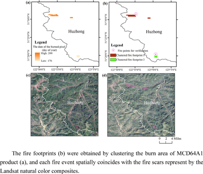
We propose an integrated framework that combines temporal classification and spatial clustering to extract fire footprints. This framework will provide more complete descriptive information than ground-based survey fire records from publicly available remote-sensing-based burn pixel products, which will assist in formulating a targeted and informed wildfire management plan and accurately account for fire-induced carbon emissions.
WF22198 Abstract | WF22198 Full Text | WF22198PDF (5.5 MB) Open Access Article
WF22048Consistent, high-accuracy mapping of daily and sub-daily wildfire growth with satellite observations
, Nathan R. Pavlovic , ShihMing Huang, Melissa Chaveste and Ningxin Wang
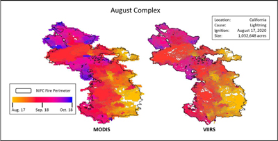
We developed a fire mapping method that uses active fire data from the MODIS and VIIRS instruments on board satellites to develop a high-resolution wildfire growth database. The satellite-derived fire events show excellent agreement with agency records (R2 ≥ 0.95). This method can enable many fire-weather modelling and real-time fire applications.
WF22048 Abstract | WF22048 Full Text | WF22048PDF (3.8 MB) | WF22048Supplementary Material (1 MB) Open Access Article
WF22188Projecting live fuel moisture content via deep learning
, Liujun Zhu, Marta Yebra, Christoph Rüdiger and Geoffrey I. Webb
We have proposed a deep learning model that makes advance predictions of fuel (vegetation) moisture content, a major driver of wildfire ignition and propagation. This proof-of-concept model produces accurate predictions with a 3-month lead time, demonstrating a potentially useful addition to wildfire management tools, facilitating early warning of high wildfire risk.
WF22188 Abstract | WF22188 Full Text | WF22188PDF (7.3 MB) | WF22188Supplementary Material (321 KB) Open Access Article
WF22184Conifer encroachment increases foliar moisture content in a northwestern California oak woodland
Stand conditions within a fire-excluded Oregon white oak ecosystem affected foliar moisture content. Encroached stands consistently had higher foliar moisture content, and were associated with stand density and leaf water potential. Better understanding of the role of stand conditions may contribute to improved modelling of potential crown fire behaviour.
WF22184 Abstract | WF22184 Full Text | WF22184PDF (1.1 MB) Open Access Article
WF22009Simulated behaviour of wildland fire spreading through idealised heterogeneous fuels
, Duncan Sutherland and Khalid Moinuddin
The effect of fuel heterogeneity was studied using physics-based grassland fire simulation. Some features, such as reduction of fire intensity, fire line length, flame length and ROS may be useful in land management and firefighting. Moreover, the non-dimensional ROS of this study is comparable with an empirical spinifex grassland model.
WF22190Adaptation of QES-Fire, a dynamically coupled fast response wildfire model for heterogeneous environments
and Brian N. Bailey
The buoyant plume rise and merging model within the wildfire progression model QES-Fire was adapted to account for heterogeneous terrain and fuels. The model compared well against an experimental burn in a complex forested region. Additionally, the model showed the need to capture the interaction between atmospheric and fire-induced winds.
WF22177The relationship between wind speed and satellite measurements of fire radiative power
Fire radiative power (FRP) is non-Gaussian, yet is often treated as such. We look at the actual distribution and how it relates to wind speed using a novel approach that preserves the distribution of FRP, rather than reducing it to a single (mean) value for a given wind speed.
WF22187Examining the influence of mid-tropospheric conditions and surface wind changes on extremely large fires and fire growth days
Mid-tropospheric moisture and stability, and surface wind changes, were examined with respect to daily growth on very large fires versus other fires. Results indicate little or no difference in growth response to any of these measures between the two sets of fires.
WF22205Climate forcing of regional fire years in the upper Great Lakes Region, USA
, Jed Meunier, Igor Drobyshev , Michael C. Stambaugh, Sara C. Hotchkiss, Eric Rebitzke and Volker C. Radeloff
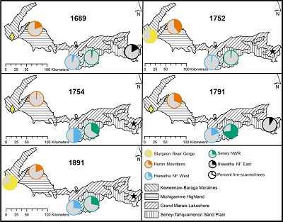
Historically, fires were frequent across the upper Great Lakes Region, with regionally widespread, primarily late-season fires occurring in 1689, 1752, 1754, 1791, and 1891. We analysed a fire-scar network, because site-specific analyses can limit interpretations, and found regional drought synchronised fire years, with climate-driven fires likely burning millions of hectares.
WF22205 Abstract | WF22205 Full Text | WF22205PDF (5.9 MB) Open Access Article
